This item has been sold, but you can get on the Waitlist to be notified if another example becomes available, or purchase a digital scan.
1913 Stanford Map of the Malay Peninsula (with manuscript Tin Region)
Malay-stanford-1913$625.00

Title
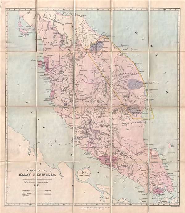
A Map of the Malay Peninsula.
1913 (dated) 26 x 22 in (66.04 x 55.88 cm) 1 : 1000000
1913 (dated) 26 x 22 in (66.04 x 55.88 cm) 1 : 1000000
Description
A scarce 1913 map of the Malay Peninsula (Malaysia) by Edward Stanford with curious manuscript annotations associated with tin mining. The map covers from the Thai Border south to include Singapore, Georgetown (Pulau Pinang), Wellesley (Seberang Perai), Dindings (Manjung), Malacca, and Singapore are highlighted in darker red. The map further identifies roads, rail lines, rubber plantations, riverways, geographical features, indigenous villages, and more. An area at the right of the map is outlined in manuscript yellow.
The manuscript work on this map is so masterfully incorporated that we did not, at first, realize we were looking at a hand drawn addition. The yellow boxed area in Eastern Malaysia, comprising Trenganu, Kemaman, Kuantan, parts of Kelantan and Legeh, is a manuscript addition to the map. As are the three roughly oval purple zones in Legeh, Trengganu, and Kuantan. At first the purpose behind these annotations confused us, but we eventually came to realize that the boxed area roughly corresponds to the Eastern Tin Zone. Tin mining, which began under the British in the Federated Malay States and the Unfederated Malays States during the 1890s became, by the early 20th century, a major regional industry. The highlighted areas reference the richest regional deposits of din, including the Sungai Lembing mines in Kuantan (and the short rail line constructed to serve them), once considered the 'El Dorado of the East' and one of the world's deepest and (at the time) richest tin deposits.
This map was issued in 1913 by Edward Stanford's Geographical Establishment from their offices as 12, 13, and 14 Long Acre, London.
Cartographer
Edward Stanford (May 27, 1827 - November 3, 1904) was one of the most prolific map publishing firms of the late 19th century. The company began as a partnership in 1848 between the 21 year old Edward Stanford and the established map dealer Trelawney Saunders. By 1853 the partnership had dissolved and Edward Stanford took full control of the business. A subsequent series of expansions and exciting new map issues finally led to the production of Stanford's masterwork, "Stanford's Library Map of London". This map is still available and remains somewhat accurate. At the time of publishing it was hailed by the Royal Geographical Society as "the most perfect map of London that has ever been issued". In 1882 Edward Stanford Sr. passed the firm on to his son, Edward Stanford Jr. who continued in his father's proud tradition. Today the Stanford firm still publishes maps and remains one of the most important and prolific cartographic publishers in the world. More by this mapmaker...
Condition
Very good condition. Manuscript annotation. Dissected an mounted on original linen. Folds into binder.
References
OCLC 776645553.