This item has been sold, but you can get on the Waitlist to be notified if another example becomes available, or purchase a digital scan.
1696 Pierre Mortier and Nicolas Sanson Map of the World in Hemispheres
MappeMonde-sanson-1696$1,000.00

Title
Mappe-Monde Dresse sur les Observations de Mrs. De L'Academie Royale des Sciences et quelques autres et sur les memories les plus recens.
1696 (undated) 20.25 x 25.5 in (51.435 x 64.77 cm) 1 : 80000000
1696 (undated) 20.25 x 25.5 in (51.435 x 64.77 cm) 1 : 80000000
Description
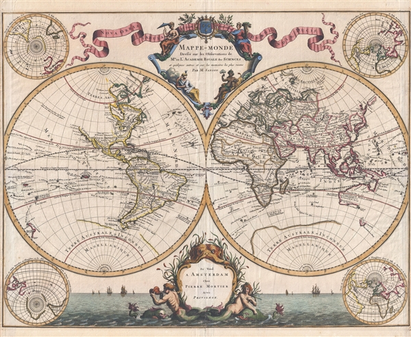
Published by Pierre Mortier and attributed to the venerable Nicolas Sanson, this scarce first edition is a beautiful 1696 map of the world in two hemispheres. The map consists of two central hemispheres, eastern and western, surrounded by four smaller polar projections. At top center there is an elaborate decorative cartouche with various allegorical elements. The entire bottom of the map is dominated by an allegorical seascape. Cartographically this map is an amalgam of Sanson's earlier work and the work of Mortier's partner in Paris, Hubert Jaillot.
Starting in North America we find a number of cartographic advances attributable to Sanson's cautious style. California has been reattached to the mainland of North America following the discoveries of the Kino expedition of the early 1700s. The northwestern part of North America, still largely unexplored, has been left blank, though the lands supposedly discovered by Jean de Gama do peak out from the Asian side of the map. In the better known parts of North America, the Mississippi is clearly mapped with its major tributaries, the Ohio and the Missouri apparent. The Rocky Mountains are not yet evident. The Great Lakes are fairly well mapped following the model established by V. Coronelli in 1691. Far to the north, the Hudson Bay and Baffin Bay, along with Greenland, form a closed network of inland seas with little suggestion of a Northwest Passage. Sanson offers only one possible route westward, an opening in the northwestern part of the Hudson Bay, which he labels Ne Ultra or 'Nothing More.' Sanson's clear rejection of a Northwest Passage to the Pacific is a bold move for the period. This decision set him in direct opposition to the colonial powers, particularly England and France, who were actively searching for just such a route. The important cities of New York, Quebec, Montreal, Charleston, St. Augustine, Santa Fe, and Boston are identified.
South America is typically well mapped along its coast which is in sharp contrast to its vague and speculative interior. Nonetheless Sanson does make a number of advances over earlier maps. He does away with Raligh's Lake Parima and El Dorado, commonly rendered in Guiana. Still, unwilling to totally give up on the El Dorado legend, he widens the Amazon in the vicinity the modern day Manaus an identifies on its shores a Village de l'Or or 'Town of Gold.' He also advances a more significant Lac de Xarayes. De L'Isle's large and prominent Lac de Xarayes is rendered as the northern terminus of the Paraguay River. The Xarayes, a corruption of 'Xaraiés' meaning 'Masters of the River,' were an indigenous people occupying what are today parts of Brazil's Matte Grosso and the Pantanal. When Spanish and Portuguese explorers first navigated the Paraguay River, as always in search of El Dorado, they encountered the vast Pantanal flood plain at the height of its annual inundation. Understandably misinterpreting the flood plain as a gigantic inland sea, they named it after the local inhabitants, the Xaraies. The Laguna de los Xarayes, accessible only through the Gate of Kings, almost immediately began to appear on early maps of the region and, at the same time, took on a legendary aspect. The Lac or Laguna Xarayes was often considered to be a gateway to the Amazon and the Kingdom of El Dorado.
Moving across the map to the Eastern Hemisphere we are immediately struck by Sanson's innovative and fascinating rendering of the discoveries in the South Pacific including Australia (Nouvelle Hollande), New Zealand, New Guinea, Vanuatu and the Solomon Islands. This ealry edition features a large hypothetical polar landmass called Terre Australis. Terre Australis was a massive continent conjectured to occupy much of the Southern Hemisphere. It was commonly believed that Terre Australis must exist to counterbalance the great weight of the Asian continent in the Northern Hemisphere just as the Americas counterbalanced Europe, Africa and Asia. Australia (Nouvelle Holland) is joined with New Guinea. Much of this erroneous geography hails from the misguided explorations of the Spaniards Mendana and Quiros. Mendana discovered, then subsequently lost, the Solomon Islands in 1567 and is responsible for their inflated size on many maps, including this one. Pedro de Quiros, Mendana's pilot, lead his own expedition to the region shortly following the Mednana expedition and, though he was unable to rediscover the Solomon Islands, did land on the southern island of Vanuatu, which he named Terre Australe de S. Espirit, expressing in the naming his belief that he had at last discovered the conjectural Terra Australis.
Asia too exhibits a number of interesting advances over previous mappings. First, Sanson does away with the popular myth of Lake Chiamay, a hypothetical source for the great river systems of Southeast Asia. The Caspian Sea appears as a large craterlike lake. Korea is firmly peninsular and is separated by Japan by the Mer Orientale. Japan, via Hokkaio (Terre d'Yeco) is attached to the Asian mainland. Just to the northeast of Japan, separated from the mainland by the Detroit d'Uries, we find Terre de La Compagnie and, extending to the opposite side of the map, Terre de Gama. Often mapped together, these lands, Gama and Terre de la Compagnie, were islands supposedly discovered in the 17th century by a mysterious figure known as Jean de Gama. Various subsequent navigators claim to have seen these lands, but it was left to Vitus Bering to finally debunk the myth. In 1729, Bering he spent three days in the region looking for Juan de Gama's island but never found it. Gama and Compagnie are little more than hopeful mis-mappings of Hokkaido and the Japanese Kuriles by Dutch explorers Maerten de Vries and Cornelis Jansz Coen. These curious islands remained on maps for about 50 years following Bering's voyages until the explorations of Cook confirmed the Bering findings.
Africa, like South America, is well mapped coastally but exhibits a conjectural and tentative interior cartography. Nonetheless, true to form, Sanson does make a number of advances. Most significantly, Sanson does away with the traditional Ptolemaic two-lake theory regarding the source of the White Nile and instead sends the White Nile eastward toward the Niger. The idea that the White Nile has a Sub-Saharan source to the west was a popular interpretation of early texts on the region through rarely appears on maps – this being the exception.
Throughout Sanson painstakingly renders the routes of various explorers including Halley, Magellan, de Schonten, Medana, Quir, Maire, Tasman, Pslsart, Chaumont, Dampier, Gaetan, Dudley, L'Ovilier, and many others. He also notes the curious and often speculative lands many of these explorers discovered, including Halley's glaciers, the Isle de Saxembourg of Linderman Holl, David Anglois' discovery in the south pacific (Easter Island?), the Island of Vaginas (a proto Hawaii?), and many others. The Sargasso Sea, the Grand Banks, and the glaciers of the Antarctic are also aparent.
There are also four smaller polar projections situated at the corners of the maps. The right hand projections focus on the Northern Hemisphere while the left hand projections depict the Southern.
Elaborate decorative cartouche work, including a stunning seascape, illustrates the upper and lower quadrants of the map. The primary title cartouche, top center, features the four great continents represented in allegorical female form, from top left: America, Europa, Africa, and Asia. Pierre Mortier's impression appears at bottom center in the mouth of a great sea monster or leviathan. A merman and a mermaid appear below the cartouche. To either side of the lower cartouche vessels of exploration ply the seas.
This map was published in early editions of Pierre Mortier's Atlas Nouveau. Shirley dates it to 1696, and we have followed his dating, but it may be earlier. Pierre Mortier's heirs, Covens and Mortier, used this map as a template for an updated map based upon the cartography of Guillaume Delisle c. 1730.
CartographerS
Pierre Mortier (January 26, 1661 - February 18, 1711) or Pieter Mortier was a cartographer, engraver, and print seller active in Amsterdam during the later 17th and early 18th centuries. Mortier, then known as Pieter, was born in Leiden. He relocated to Paris from 1681 to 1685, adopting the French name Pierre, which he retained throughout his career. While in France, he developed deep French connections by bringing sophisticated Dutch printing technology and experience to nascent French map publishers such as Guillaume De L'Isle (1675 - 1726), Alexis-Hubert Jaillot (c. 1632 - 1712), and Nicholas de Fer (1646 - 1720). Consequently, much of Mortier's business was built upon issuing embellished high quality editions of contemporary French maps - generally with the permissions of their original authors. In the greater context of global cartography, this was a significant advantage as most Dutch map publishes had, at this point, fallen into the miasma of reprinting their own outdated works. By contrast, the cartographers of France were producing the most accurate and up to date charts anywhere. Mortier's cartographic work culminated in the magnificent nautical atlas, Le Neptune Francois. He was awarded the Privilege, an early form of copyright, in 1690. Upon Pierre's death in 1711 this business was inherited by his widow. In 1721, his son Cornelius Mortier took over the day to day operation of the firm. Cornelius partnered with his brother-in-law Jean Covens to form one of history's great cartographic partnerships - Covens and Mortier - which continued to publish maps and atlases until about 1866. More by this mapmaker...
Nicolas Sanson (December 20, 1600 - July 7, 1667) and his descendants were the most influential French cartographers of the 17th century and laid the groundwork for the Golden Age of French Cartography. Sanson was born in Picardy, but his family was of Scottish Descent. He studied with the Jesuit Fathers at Amiens. Sanson started his career as a historian where, it is said, he turned to cartography as a way to illustrate his historical studies. In the course of his research some of his fine maps came to the attention of King Louis XIII who, admiring the quality of his work, appointed Sanson Geographe Ordinaire du Roi. Sanson's duties in this coveted position included advising the king on matters of geography and compiling the royal cartographic archive. In 1644, he partnered with Pierre Mariette, an established print dealer and engraver, whose business savvy and ready capital enabled Sanson to publish an enormous quantity of maps. Sanson's corpus of some three hundred maps initiated the golden age of French mapmaking and he is considered the 'Father of French Cartography.' His work is distinguished as being the first of the 'Positivist Cartographers,' a primarily French school of cartography that valued scientific observation over historical cartographic conventions. The practice result of the is less embellishment of geographical imagery, as was common in the Dutch Golden Age maps of the 16th century, in favor of conventionalized cartographic representational modes. Sanson is most admired for his construction of the magnificent atlas Cartes Generales de Toutes les Parties du Monde. Sanson's maps of North America, Amerique Septentrionale (1650), Le Nouveau Mexique et La Floride (1656), and La Canada ou Nouvelle France (1656) are exceptionally notable for their important contributions to the cartographic perceptions of the New World. Both maps utilize the discoveries of important French missionaries and are among the first published maps to show the Great Lakes in recognizable form. Sanson was also an active proponent of the insular California theory, wherein it was speculated that California was an island rather than a peninsula. After his death, Sanson's maps were frequently republished, without updates, by his sons, Guillaume (1633 - 1703) and Adrien Sanson (1639 - 1718). Even so, Sanson's true cartographic legacy as a 'positivist geographer' was carried on by others, including Alexis-Hubert Jaillot, Guillaume De L'Isle, Gilles Robert de Vaugondy, and Pierre Duval. Learn More...
Source
Mortier, P., Atlas Nouveau (Amsterdam) 1696.
Condition
Very good. Minor centerfold wear and reinforcement. Expert repairs to right and left margins. Else very clean.
References
Shirley, Rodney W., The Mapping of the World: Early Printed World Maps 1472-1700, #581. OCLC 220805726.