This item has been sold, but you can get on the Waitlist to be notified if another example becomes available, or purchase a digital scan.
1885 Martenet Map of Maryland, Delaware, and Washington D.C.
Maryland-martenet-1885$625.00


Title
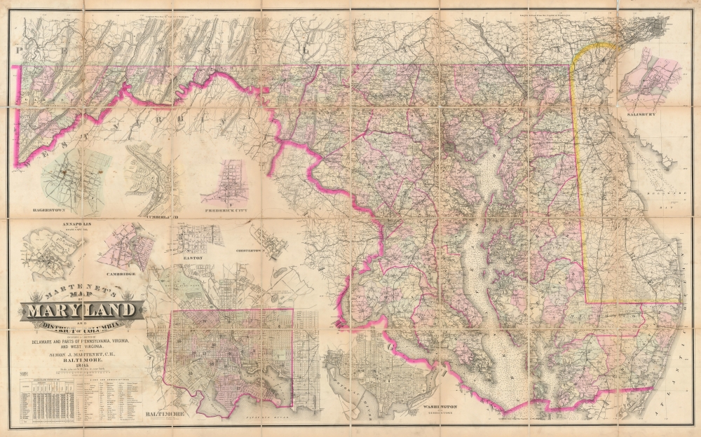
Martenet's Map of Maryland and District of Columbia including a sketch of Delaware and Parts of Pennsylvania, Virginia, and West Virginia.
1885 (dated) 45.75 x 73.22 in (116.205 x 185.9788 cm) 1 : 221760
1885 (dated) 45.75 x 73.22 in (116.205 x 185.9788 cm) 1 : 221760
Description
A remarkable 1885 large format sectionalized map of Maryland and Washington D. C. by Simon J. Martenet. The represents the culmination of Martenet's mapmaking career, which he called 'A Beautiful Work.' When published, this map was considered the largest and best map of Maryland yet issued and was adopted by the State Legislature for administrative use.
A Closer Look
On an immense wall-map level scale, Martenet covers all of Maryland and Delaware, as well as Washington D. C. Insets include Baltimore, Hagerstown, Cumberland, Frederick City, Annapolis, Cambridge, Easton, and Chestertown. The whole folds into a worm but handsome binder.Publication History and Census
This map was copyrighted by Simon J. Martenet in 1884 and issued in 1885. It follows on a similar map of Maryland issued in 1865, just after the American Civil War (1861 - 1865), but is a new and heavily revised edition with a different title. According to firm records, the map was updated several times until the plates were destroyed in the Great Baltimore Fire of 1904. Nonetheless, we have found no surviving record of updated editions. The 1885 edition of this map, as here, we have found in just 3 institutions. The earlier version, 1865, is more common. Martenet considered the two editions completely separate works, despite their superficial similarity.Cartographer
Simon Jonas Martenet (April 13, 1832 - November 6, 1892) was a Baltimore based map publisher, surveyor, and civil engineer active in the second half of the 19th century. Martenet went through the Baltimore public school system, graduating in July of 1847. He began his career in March of 1849, 2 years later. He trained as a surveyor working for the Baltimore city surveyor Thomas P. Chiffelle. From roughly 1853 to 1869 he served I the Baltimore City Militia. He began issuing maps around 1858, most of which consisted of city and state maps of Maryland. He joined the Society of Friends, the Quakers, in 1862. In 1867, he was elected Baltimore City Surveyor, taking over Chiffelle's role. He held this position on and off until 1879. Martenet died of a stroke in Baltimore in 1892. Martenet was a member of the Odd Fellows and Red Men fraternal orders. He lived at 208 East Lexington Street, Baltimore. The firm he founded, S. R. Martenet, remains in business today. More by this mapmaker...
Condition
Very good. The map is intact with some toning on old fold lines. Original linen backing is exceedingly brittle and reinforced here and there with archival tissue. Attached to restored binder with fresh linen.
References
OCLC 10869880.