Digital Image: 1922 Hoehne Map of the Mato Grosso, Brazil
MattoGrosso-hoehne-1922_d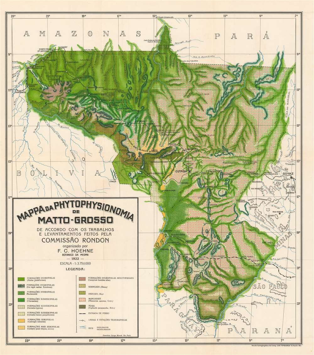

Title
Mapa da Phytophysionomia de Matto-Grosso de Accordo com os Trabalhos e Levantamentos Feitos Pela Commissão Rondon. (Map of the Mato Grosso Phytophysiognomy According to the Works and Surveys Made by the Rondon Commission.)
1922 (dated) 25.25 x 22.5 in (64.135 x 57.15 cm) 1 : 3750000
1922 (dated) 25.25 x 22.5 in (64.135 x 57.15 cm) 1 : 3750000
Description
FOR THE ORIGINAL ANTIQUE MAP, WITH HISTORICAL ANALYSIS, CLICK HERE.
Digital Map Information
Geographicus maintains an archive of high-resolution rare map scans. We scan our maps at 300 DPI or higher, with newer images being 600 DPI, (either TIFF or JPEG, depending on when the scan was done) which is most cases in suitable for enlargement and printing.
Delivery
Once you purchase our digital scan service, you will receive a download link via email - usually within seconds. Digital orders are delivered as ZIP files, an industry standard file compression protocol that any computer should be able to unpack. Some of our files are very large, and can take some time to download. Most files are saved into your computer's 'Downloads' folder. All delivery is electronic. No physical product is shipped.
Credit and Scope of Use
You can use your digial image any way you want! Our digital images are unrestricted by copyright and can be used, modified, and published freely. The textual description that accompanies the original antique map is not included in the sale of digital images and remains protected by copyright. That said, we put significant care and effort into scanning and editing these maps, and we’d appreciate a credit when possible. Should you wish to credit us, please use the following credit line:
Courtesy of Geographicus Rare Antique Maps (https://www.geographicus.com).
How Large Can I Print?
In general, at 300 DPI, you should at least be able to double the size of the actual image, more so with our 600 DPI images. So, if the original was 10 x 12 inches, you can print at 20 x 24 inches, without quality loss. If your display requirements can accommodate some loss in image quality, you can make it even larger. That being said, no quality of scan will allow you to blow up at 10 x 12 inch map to wall size without significant quality loss. For more information, it is best consult a printer or reprographics specialist.
Refunds
If the high resolution image you ordered is unavailable, we will fully refund your purchase. Otherwise, digital images scans are a service, not a tangible product, and cannot be returned or refunded once the download link is used.
Cartographer
Frederico Carlos Hoehne (February 1, 1882 - March 16, 1959) was a Brazilian ecologist, taxonomist, and botanist. Hoehne was born in Juiz de Fora and his parents ran an orchid hothouse and farm. He was homeschooled before attending the Colégio Americano, where he continued his education in botany under the guidance of João Barbosa Rodrigues and Emilio Jobet. He was named head gardener (jardiniere-chefe) at the National Museum in Rio de Janeiro in 1907. He soon became involved in the Rondon Commission and conducted surveys of plant life in the Mato Grosso and Amazonas regions. He also participated in the expeditions surrounding the establishment of the telegraph lines in 1910 and served as the botanist on the Roosevelt-Rondon expedition, which was in the field in 1913-1914. By 1917 he held a position at the Instituto de Botánica in São Paulo and was named director in 1942. Hoehne was a prolific author, contributing to the final reports of all the major expeditions of which he was a part, as well as writing numerous books and well over fifty articles. He founded the Botanical Garden of São Paulo, and was also director of the Butantan Institute and the São Paulo Zoo. He married Carla Augusta Frieda Kulhmann in 1907, with whom he had four children. More by this mapmaker...