This item has been sold, but you can get on the Waitlist to be notified if another example becomes available, or purchase a digital scan.
1885 De Witt Alexander Wall Map of Maui, Hawaii
Maui-lo-1885$500.00

Title
Hawaiian Government Survey, W.D. Alexander. Surveyor- General.Maui Hawaiian Islands.
1885 (dated) 44 x 53.5 in (111.76 x 135.89 cm)
1885 (dated) 44 x 53.5 in (111.76 x 135.89 cm)
Description
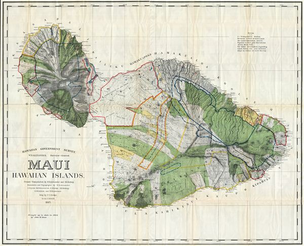
This very large, rare, and extraordinary 1885 map of the island of Maui, Hawaii, was prepared for the 1906 Report of the Governor of the Territory of Hawaii to the Secretary of the Interior. Covers the entire island in stupendous detail. Though the cartographic work that produced this map was started in 1885, during the Hawaiian Monarchy, the map itself, and the report that contained it, was issued following the U.S. Government's 1898 annexation of the Hawaiian Republic. The Report was an attempt to assess and examine the newly created Hawaiian Territory's potential for proper administration and development. Consequently the map focuses on Public Lands, Homestead Settlement Tracts, Grazing Lands, Pineapple Lands, Sugar Plantations, Forest Reserves, Forest Lands, Wet Lands, etc. It also features both practical and topographic details for use in administering the region. The governor at this time was George R. Carter. The primary triangulation for this map was accomplished by W.D. Alexander and S.E. Bishop. The topography is the work of W.D. Alexander, C. J. Lyons, M. D. Monsarrat, F.S. Dodge, S. E. Bishop, E.D. Baldwin and W. R. Lawrence. The map was drawn by F. S. Dodge.
CartographerS
The General Land Office (1812 - 1946) was an independent agency charged with the administration and sale of public lands of the western territories of the United States under the Preemption Act of 1841 and the Homestead Act of 1862. During a time of frenetic energy and rapid westward expansion, the Land Office oversaw the surveying, platting, mapping and eventually the sale of much of the Western United States and Florida. The structural layout of the western United States that we see today, and many of their district and county divisions, are direct result of the early surveying work of the General Land Office. More importantly, as a branch of the Federal Government in Washington D.C. and the only agency able to legally sell and administer public lands in the western territories of the United States, the General Land Office played a pivotal role in consolidating power away from the original states and into the hands of the centralized federal government. The General Land Office was absorbed into the Department of Interior in 1849 and in 1946 merged with the United States Grazing Service to become the Bureau of Land Management. Today the Bureau of Land Management administers the roughly 246 million acres of public land remaining under federal ownership. More by this mapmaker...
William De Witt Alexander (1833 - 1913) was a Hawaiian born historian, publisher, writer, surveyor, and teacher. Alexander was born in Honolulu in 1833 and received a degree from Yale University in 1855. After completing his studies Alexander returned to Hawaii where he taught Greek and history at the Punahou School. During this time Alexander published a number of books on Hawaiian history and ethnography. After nearly thirteen years in education Alexander accepted a commission with Royal Bureau of Government Survey. In this office Alexander did much of his most important work in mapping the Hawaiian Islands. Eventually he attained the office of Surveyor-General of the Territory of Hawaii and a high position in the Privy Council of Kalakaua and Lili'uokalani. When Hawaii was annexed into the United States, Alexander assisted the United States Coast and Geodetic Survey in properly mapping the islands. Learn More...
Source
Report of the Governor of the Territory of Hawaii to the Secretary of the Interior, (1906 edition).
Condition
Very good condition. Minor discoloration on original fold lines. Minor transference. Blank on verso.
References
Library of Congress Geography and Map Division Washington, G4382.M3 1885 .D6.