Digital Image: 1860 Vaux Plan of the Merchant's Gate in Central Park, New York City (Columbus Circle
MerchantsGate-vaux-1860_d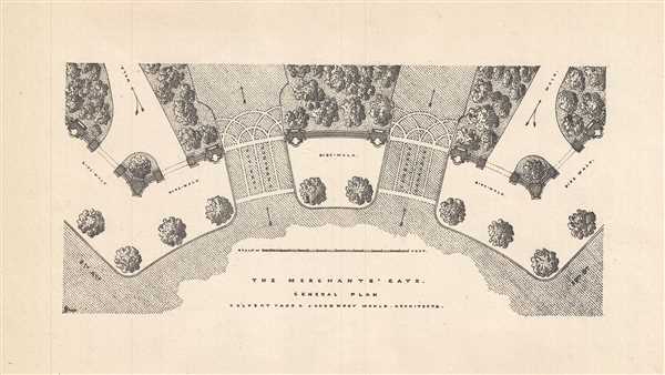

Title
The Merchant's Gate. General Plan.
1860 (undated) 4 x 7.5 in (10.16 x 19.05 cm)
1860 (undated) 4 x 7.5 in (10.16 x 19.05 cm)
Description
FOR THE ORIGINAL ANTIQUE MAP, WITH HISTORICAL ANALYSIS, CLICK HERE.
Digital Map Information
Geographicus maintains an archive of high-resolution rare map scans. We scan our maps at 300 DPI or higher, with newer images being 600 DPI, (either TIFF or JPEG, depending on when the scan was done) which is most cases in suitable for enlargement and printing.
Delivery
Once you purchase our digital scan service, you will receive a download link via email - usually within seconds. Digital orders are delivered as ZIP files, an industry standard file compression protocol that any computer should be able to unpack. Some of our files are very large, and can take some time to download. Most files are saved into your computer's 'Downloads' folder. All delivery is electronic. No physical product is shipped.
Credit and Scope of Use
You can use your digial image any way you want! Our digital images are unrestricted by copyright and can be used, modified, and published freely. The textual description that accompanies the original antique map is not included in the sale of digital images and remains protected by copyright. That said, we put significant care and effort into scanning and editing these maps, and we’d appreciate a credit when possible. Should you wish to credit us, please use the following credit line:
Courtesy of Geographicus Rare Antique Maps (https://www.geographicus.com).
How Large Can I Print?
In general, at 300 DPI, you should at least be able to double the size of the actual image, more so with our 600 DPI images. So, if the original was 10 x 12 inches, you can print at 20 x 24 inches, without quality loss. If your display requirements can accommodate some loss in image quality, you can make it even larger. That being said, no quality of scan will allow you to blow up at 10 x 12 inch map to wall size without significant quality loss. For more information, it is best consult a printer or reprographics specialist.
Refunds
If the high resolution image you ordered is unavailable, we will fully refund your purchase. Otherwise, digital images scans are a service, not a tangible product, and cannot be returned or refunded once the download link is used.
Cartographer
Calvert Vaux (1824 - 1895) was a British architect and landscaper who is best remembered for his co-design, with Frederick Olmstead, of New York City's Central Park. Born in London in 1824, little is known of his early life, though it is recorded that, at 9 he was apprenticed to London architect Lewis Nockalls Cottingham, a proponent of the Gothic Revival Movement. Vaux worked for Cottingham until he was 26 years old, honing his skills and building a reputation as a skilled draftsman. During an exhibition of his watercolors in 1851, Vaux caught the attention of landscape designer Andrew Jackson Downing. Downing was looking for a partner to fulfill his revolutionary vision of urban architectural-landscaping. Dowing recruited Vaux to design buildings, bridges, and structures, while he focused on the overall landscape design. Vaux accompanied Downing to the United States where, in 1854, he gained U.S. citizenship and founded the American Institute of Architects. Vaux's partnership with Downing lasted approximately two years and resulted in a number of significant works, including the grounds of the White and Smithsonian Institute in Washington D.C. In 1852 Downing passed away in a tragic accident. At the time Downing was working on a landscape design for New York City's Central Park. In a decision that would forever change the American urban landscape, Vaux called in the fledgling landscape designer Frederick Olmstead to fill Downing shoes. Though Central Park was their first joint project, Vaux and Olmstead proved a magical combination, creating what many consider to be the finest planed urban recreation area in the world. Following the completion of Central Park, Vaux and Olmstead formed an official business partnership and went on to design Prospect Park in Brooklyn and Morningside Park in upper Manhattan. They planned one of the first suburbs in Chicago, Riverside, and were commissioned to design parks for Buffalo, NY, Milwaukee, WI, and Rockwood Park in Canada, among others. Vaux ended the partnership in 1872 and went on to collaborate with George Kent Radford and Samuel Parsons. However, in 1889 he again joined forces with Olmstead to design Downing Park, as a memorial to his mentor. Vaux tragically passed away on November 19, 1895, when he drowned in Brooklyn, NY. More by this mapmaker...