1745 Mannevillette First Edition Map of the Mergui Archipelago
Mergui-mannevillette-1745$2,500.00

Title
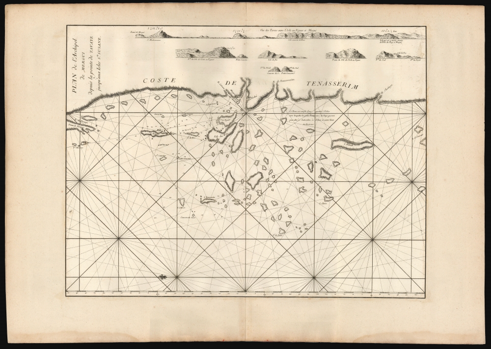
Plan de l'Archipel de Mergui depuis la pointe de Tsavaye jusqu'aux Isles Ste. Susane.
1745 (undated) 17.5 x 23.25 in (44.45 x 59.055 cm) 1 : 580000
1745 (undated) 17.5 x 23.25 in (44.45 x 59.055 cm) 1 : 580000
Description
This is the extremely rare 1745 first edition of D'Après de Mannevillette's groundbreaking chart of the Mergui archipelago on the coast of southern Burma. It is the first printed map to show the region in detail and to include evidence of firsthand navigation. For southeast Asia, in particular, Mannevillette's 1745 nautical atlas was 'immediately recognised as being superior to all previous maps of Southeast Asian coasts' (Suárez, p.238).
A Closer Look
Although the chart's title orients the reader to the north, the text within the body of the chart is oriented to the east, which for the purpose of reading the chart must be construed as its primary orientation. It covers the coastline of the Tenasserim region from Point Tavoy in the north to Isle St. Suzane in the south. Centered on the town of Mergui (present-day Myeik), the chart prominently presents the island of Kadan Kyun, here named Isle du Roy. Major islands at the rim of the archipelago are also named, such as the Island of Tenasserim and Isla Clara. The chart includes a series of coastal profiles intended to accompany the routes on the chart marked with depth soundings and anchorages. The routes in question run into the archipelago from the northwest, arriving at the anchorages at the Isle du Roy and Mergui. That there were more islands to the archipelago than he depicted, Mannevillette admits: this bank is filled with a quantity of islands, between which the small ships of this country pass to go to Junkseilon (Phuket), Achem (Aceh, on Sumatra) and other places in the surrounding area. Indeed, Malay and Chinese traders relied on the inner waters of the archipelago to avoid monsoons, while pirates and slavers relied on the archipelago because of the impossibility of charting and controlling it.A Contested Frontier
The coastline and archipelago depicted here are now part of the southern extent of Myanmar. When the chart was made, most maps presented Tenasserim as part of the Ayutthaya kingdom of Siam; by the 1760s, it was captured by Burma. Great Britain would, in turn, capture the archipelago from Burma at the beginning of the 19th century.A Censored First Edition
All maps from the 1745 first edition of the Neptune Oriental are as significant as they are rare. The atlas followed Mannevillette's 1728 voyage to China, wherein he corrected latitudes and made new charts along the route using the most up-to-date hydrographic instruments. When he returned to France, he devised a plan to publish new maps of the route to China, including charts of the Persian Gulf, the Red Sea, and the coasts of India, Malaya, the northern parts of Indonesia, Indochina, and China. His Neptune Oriental, published for the Compagnie des Indes (French East India Company), appeared in 1745 and features twenty-five groundbreaking maps. In reviewing the work, the French Admiralty considered the information to be so accurate and advanced over earlier charts that it threatened French colonial and maritime interests in the Far East. According to Filliozat, 'the French Admiralty considering that the Neptune Oriental was too dangerous... navigation ordered the remaining copies to be destroyed' (Filliozat, Manonmani, Indian Journal of History of Science, 292, 1994, p. 341). Consequently, despite much revised and expanded issues of the Neptune Orientale appearing in 1775 (fifty-nine maps) and 1775 - 1781, the important first edition remains exceedingly rare. While the 1775 edition is common, we note only three surviving examples of the 1745 edition in the OCLC.Publication History and Census
This map was engraved by Guillaume d'Heulland for the 1745 first edition of D'Après de Mannevillette's Neptune Oriental. Like all the maps from this edition, most examples were censored and destroyed. The map was replaced in the 1775 second edition of the Neptune Oriental with a completely new Persian Gulf map based upon the navigations of René Julien Le Floch de la Carrière (1730 - 1792). We see examples of the separate chart only at the Bibliothèque nationale de France. The full 1745 edition of the atlas is known at the Library of Congress and the Bibliothèque nationale de France.This is the rare 1745 first edition of D'Après de Mannevillette's groundbreaking chart of the Mergui Archipelago on the coast of southern Burma. It is the first printed map to show the region in detail and to include evidence of firsthand navigation. For southeast Asia, in particular, Mannevillette's 1745 nautical atlas was 'immediately recognised as being superior to all previous maps of Southeast Asian coasts' (Suárez, p.238).A Closer Look
Although the chart's title orients the reader to the north, the text within the body of the chart is oriented to the east, thus its primary orientation. It covers the coastline of Tenasserim from Point Tavoy in the north to Isle St. Suzane in the south. Centered on Mergui (present-day Myeik), the chart also prominently presents the island of Kadan Kyun, here named Isle du Roy. Major islands at the rim of the archipelago are also named, such as the Island of Tenasserim, and Isla Clara. The chart includes a series of coastal profiles intended to accompany the routes on the chart marked with depth soundings and anchorages. The routes in question run into the archipelago from the northwest to arrive at the anchorages at the Isle du Roy and Mergui. That there were more islands to the archipelago than he depicted, Mannevillette admits: 'this bank is filled with a quantity of islands, between which the small ships of this country pass to go to Junkseilon (Phuket) Achem (Aceh, on Sumatra) and other places in the surrounding area.' Indeed, Malay and Chinese traders relied on the inner waters of the archipelago to avoid monsoons, whilst pirates and slavers relied on the archipelago because of the impossibility of charting and controlling it.A Contested Frontier
The coastline and archipelago depicted here are now part of the southern extent of Myanmar. At the time the chart was made, most maps presented Tenasserim as part of the Ayutthaya kingdom of Siam. By the 1760s, it was captured by Burma, and in the early 19th century, Great Britain seized the archipelago.A Censored First Edition
All maps from the 1745 first edition of the Neptune Oriental are as significant as they are rare. The atlas followed Mannevillette's 1728 voyage to China, wherein, using the most up-to-date hydrographic instruments, he corrected latitudes and made new groundbreaking charts. When he returned to France, he published the new maps, including charts of the Persian Gulf, the Red Sea, the coasts of India, Malaya, the northern parts of Indonesia, Indochina, and China. His Neptune Oriental, published for the Compagnie des Indes (French East India Company), appeared in 1745 and features 25 groundbreaking maps. In reviewing the work, the French Admiralty considered the information contained to be so accurate and so advanced over earlier charts that it was a threat to French colonial and maritime interests in the Far East. According to Filliozat, 'the French Admiralty considering that the Neptune Oriental was too dangerous... navigation, ordered the remaining copies to be destroyed' (Filliozat, Manonmani, Indian Journal of History of Science, 292, 1994, p. 341). Consequently, despite much revised and expanded issues of the Neptune Orientale appearing in 1775 (59 maps) and 1775 - 1781, the important first edition remains exceedingly rare. While the 1775 edition is common, we note only three surviving examples of the 1745 edition in the OCLC.Publication History and Census
This map was engraved by Guillaume d'Heulland for the 1745 first edition of D'Après de Mannevillette's Neptune Oriental. Like all the maps from this edition, most examples were censored and destroyed. We see examples of the separate chart only at the Bibliothèque Nationale de France. The full 1745 edition of the atlas is known at the Library of Congress and the Bibliothèque Nationale de France.Cartographer
Jean-Baptiste Nicolas Denis d'Après de Mannevillette (February 11, 1707 - March 1, 1780) was a French sailor, navigator, and hydrographer active in the mid-18th century. Mannevillette was born in Le Havre to a family of wealthy seafarers. He completed his first major voyage at 12, when he accompanied his father, Jean-Baptiste-Claude d'Après de Blangy, a captain of the Compagnie des Indes (French East India Company) vessel Solide to Bengal. On his return to France, he he studied mathematics and navigation in Paris under Joseph Nicholas De L'Isle (1688 - 1768) before returning to the sea at 19 as a fourth officer as on the merchant vessel Marechel d'Estrees. Mannevillette himself eventually attained the rank of Captain with the Compagnie des Indes. In the course of numerous voyages around Africa to India and China, Mannevillette collected and revised numerous nautical charts. His sophisticated use of the most modern instruments, most specifically the Octant or English Quarter, and keen mathematical mind, enabled Mannevillette to correct many significant errors common to earlier maps. These updates were eventually compiled and published in Mannevillette's most significant work, the 1745 Le Neptune Oriental. The 1745 Neptune Oriental was commissioned by the Compagnie des Indes and its production earned Mannevillette admission into the Academy of Sciences. The atlas was well received, but shortly after publication, most unsold examples were destroyed by the French Admiralty, who considered the secrets of East Indian navigation too dangerous for dissemination. In 1762 the Compagnie des Indes appointed Mannevillette director of chart at Lorient. In 1767 King Louis XV conferred the Order of St. Michael upon him and made him an associate of the Royal Marine Academy. In the 30 years following his first publication of Le Neptune Oriental, Mannevillette worked doggedly with his lifelong friend, Alexander Dalrymple (1737 - 1808) to update his original work with new and improved charts. In 1775, he republished his opus in a greatly expanded format - by this time nautical information was less tightly guarded. Mannevillette died on March 1, 1780 at 75 years of age. More by this mapmaker...
Source
D'Après de Mannevillette, Neptune Oriental, (Paris) 1745.
Le Neptune Oriental was a large-scale maritime atlas first issued in 1745 by Jean-Baptiste Nicolas Denis d'Après de Mannevillette, a wealthy French sailor and hydrographer. From his first voyage as an adult in 1726, Mannevillette collected, revised, and created new nautical charts. These he published 20 years later in the first edition of Le Neptune Oriental, an important work issued for the Compagnie des Indes (French East India Company), for whom Mannevillette was a captain. The first edition of Le Neptune Oriental containing 25 charts, was received and earned him accolade on both navigational and scientific circles. Nonetheless, according to Manonmani Filliozat, writing in the Indian Journal of the History of Science,
The French Admiralty considering that the Neptune Oriental was too dangerous ... ordered the remaining copies to be destroyed. (#292, 1994, p. 341)This accounts somewhat for the extreme scarcity of the first edition and all of the maps contained therein. We also note a supportive comment in a, 1763 catalog of maps and charts issued by the French chart and map dealer Roch-Joseph Julien (1745 - 1779). Mannevillette nonetheless continued to collect and revise charts for the next 30 years, often working with the important English cartographer Alexander Dalrymple (1737 - 1808). In 1775, he issued greatly expanded and updated second edition of Le Neptune Oriental. This time with an additional 41 charts, making a total of 63 charts. This edition also proved popular and was widely disseminated. As noted by multiple cartobibliographers, there are variations between examples and no two seem to be identical, suggesting that many were compiled to order, often with additional maps that could be purchased but which were not in the standard collation. The second edition was published in Paris by Demonville and in Brest by Malassis. In 1781, one year after Mannevillette's, another work, Supplement au Neptune Oriental was issued, also by Demonville and Malassis.
Condition
Very good. The chart has been trimmed to the neatline and laid down on period paper - likely by the original binder. No loss.
References
Bibliothèque nationale de France, département Cartes et plans, GE DD-2987 (6746).