This item has been sold, but you can get on the Waitlist to be notified if another example becomes available, or purchase a digital scan.
1961 U.S. Geological Survey Set of Three Maps of the Moon
MoonMapSet-usgs-1961$1,125.00

Title
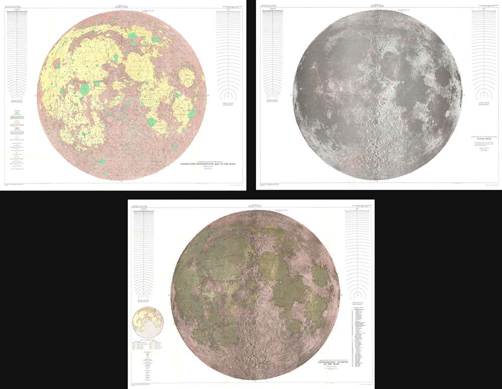
Engineer Special Study of the Surface of the Moon Generalized Photogeologic Map of the Moon. / Lunar Rays. / Physiographic Divisions of the Moon.
1961 (dated) 40 x 52 in (101.6 x 132.08 cm) 1 : 3800000
1961 (dated) 40 x 52 in (101.6 x 132.08 cm) 1 : 3800000
Description
This is a set of three 1961 landmark maps of the Moon made by the U.S. Geological Survey in preparation for the Apollo 11 Lunar Landing Mission. All three represent the near side of the Moon on a scale of 1:3,800,000. Each map illustrates the Moon in a different spectacular monumentally proportioned manner and illustrates the physical geography of the moon, noting craters, seas, mountains, and other formations.
The Three Maps
The first map is a general photogeologic map of the Moon and highlights the different kinds of rock formations present on the Moon. The second pays special attention to 'lunar rays.' Lunar rays are the streaks of fine ejecta, appearing almost like the spokes of a wheel, surrounding many of the moon's largest impact craters. The third map in the set focuses on the physiographic attributes of the Moon, labeling the different maria, mountain ranges, and provinces. An index of all these locations is included along the right side.The Set in General
The work done in compiling these map led Robert J. Hackman to develop the basis for all future planetary mapping and laid the foundations for photogeology, the use of aerial photography to study the geology of a region. Arthur C. Clarke's lunar explorers used these maps for their 'Journey by Earthlight' in 2001: A Space Odyssey.Publication History
These maps were originally prepared by the scientists Robert J. Hackman and Arnold C. Mason in 1960 based on photographs taken at Lick Observatory, San Jose, California. This is the second edition issued in 1961.Cartographer
The United States Geological Survey (1878 - Present), aka the U.S.G.S., is a scientific agency of the United States government, which was founded in 1879. USGS scientists study the landscape of the United States, its natural resources, and the natural hazards that threaten it. The organization has four major science disciplines: biology, geography, geology, and hydrology. It is a bureau of the United States Department of the Interior and is the department's only scientific agency. More by this mapmaker...
Source
Hackman, R. & Mason, A., Engineer Special Study of the Surface of the Moon, 1961 (2nd edition).
Condition
Set of three (3) maps. All exhibit light wear along original fold lines. Closed 1/16 inch tear near center of Lunar Rays map professionally repaired on verso. All blank on verso.
References
Clarke, A. C., 2001: A Space Odyssey, 'Journey by Earthlight'. Lunar and Planetary Institute, USGS I 351.