Digital Image: 1887 Colby Stuart Wall Map of Mount Desert Island, Maine (Acadia National Park)
MountDesertIsland-colbystuart-1887_d

Title
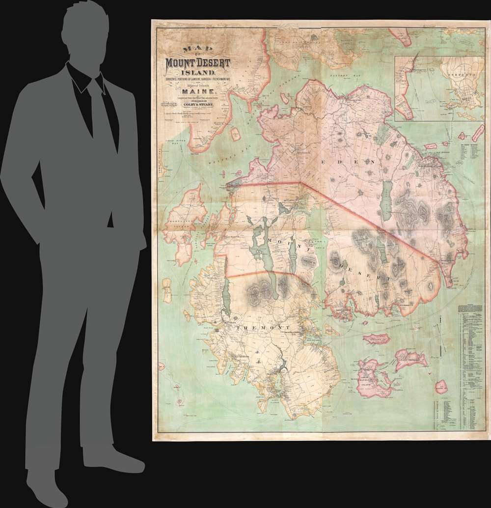
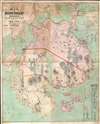
Map of Mount Desert Island, Sorrento, Portions of Lamoine, Hancock, and Frenchman's Bay, and Adjacent Islands, Maine.
1887 (dated) 64.75 x 52.25 in (164.465 x 132.715 cm) 1 : 17820
1887 (dated) 64.75 x 52.25 in (164.465 x 132.715 cm) 1 : 17820
Description
FOR THE ORIGINAL ANTIQUE MAP, WITH HISTORICAL ANALYSIS, CLICK HERE.
Digital Map Information
Geographicus maintains an archive of high-resolution rare map scans. We scan our maps at 300 DPI or higher, with newer images being 600 DPI, (either TIFF or JPEG, depending on when the scan was done) which is most cases in suitable for enlargement and printing.
Delivery
Once you purchase our digital scan service, you will receive a download link via email - usually within seconds. Digital orders are delivered as ZIP files, an industry standard file compression protocol that any computer should be able to unpack. Some of our files are very large, and can take some time to download. Most files are saved into your computer's 'Downloads' folder. All delivery is electronic. No physical product is shipped.
Credit and Scope of Use
You can use your digial image any way you want! Our digital images are unrestricted by copyright and can be used, modified, and published freely. The textual description that accompanies the original antique map is not included in the sale of digital images and remains protected by copyright. That said, we put significant care and effort into scanning and editing these maps, and we’d appreciate a credit when possible. Should you wish to credit us, please use the following credit line:
Courtesy of Geographicus Rare Antique Maps (https://www.geographicus.com).
How Large Can I Print?
In general, at 300 DPI, you should at least be able to double the size of the actual image, more so with our 600 DPI images. So, if the original was 10 x 12 inches, you can print at 20 x 24 inches, without quality loss. If your display requirements can accommodate some loss in image quality, you can make it even larger. That being said, no quality of scan will allow you to blow up at 10 x 12 inch map to wall size without significant quality loss. For more information, it is best consult a printer or reprographics specialist.
Refunds
If the high resolution image you ordered is unavailable, we will fully refund your purchase. Otherwise, digital images scans are a service, not a tangible product, and cannot be returned or refunded once the download link is used.
Cartographer S
George Nehemiah Colby (January 13, 1846 - 1890) was an American civil engineer and map publisher active in Houlton, Maine in the late 19th century. Colby was born in South Berwick Maine and was married to Julie Gertrude Ganong (1853 – 1889). Colby's corpus of work consists primarily of Maine focused wall maps, county and state atlases, and more specific regional maps, for which he personally compiled surveys and sold by subscription. Colby initially worked with the U.S. Coast Survey, where his work contributed to the survey's important 1881 map of Mount Desert Island, Maine. In the private market Colby published Maine centered material in the style of Massachusetts cartographer Henry Walling. That is to say, he issued highly detailed maps on a large scale that he sold by subscription to local institutions and land owners. Colby's maps, like Walling's, are exceptionally desirable for anyone interested in family history, as they often list individual family names and land holdings. Colby pwartnered Frederick B. Roe in 1873 to issue wall maps of several Maine towns including New Brunswick, Thomaston, Bath, and Camden. This partnership lasted until about 1878 and maintained offices in Philadelphia at 31 South 6th Street. Colby later partnered with Joseph Harry Stuart (1855 - 183?) to similarly publish subscription-based maps and atlases of Maine counties and communities. When Colby retired in the 1890s, Stuart fully took over his business, continuing to publish as J. N Stuart into the 1930s. Colby and his wife had three children, George Nehemiah, Frederik Franklin, and Mary Gertrude. More by this mapmaker...
Joseph Harry Stuart (September 20, 1855 - 193?) was an American surveyor, civil engineer, and map publisher based in South Paris, Maine. Stuart was born in Bethel, Maine and married Mary Crafts Whitman (April 13, 1857 - 1934) of South Pairs, Maine, in 1878. He primarily worked and published as 'J. H. Stuart and Co.' Later, he partnered with George Nehemiah Colby (1846 - 1890), creating the firm of 'Colby and Stuart', publisher of Maine county atlases and wall maps. Likely he also maintained an office in Philadelphia, Pennsylvania where many of his maps and atlases were engraved. He appears in the South Paris city directory from about 1900 to about 1932 as a civil engineer, surveyor, and map publisher based at 61 High Street. He likely died between 1932 and 1936, but we have identified no records. Learn More...
William Bracher (June 29, 1829 - May 14, 1912) was a Philadelphia based engraver and lithographer active in the late 19th century. Bracher was born in Göppingen, Badan-Württemberg, Germany. He was a 48er, who emigrated to the United States in 1848 with his wife Amelia A. M. Bracher (born Naigele), fleeing the failed Springtime of the Peoples Revolutions (1848 - 1849). He settled in Philadelphia, where he established himself as line and stipple engraver as early as 1861. He was naturalized as a U.S. citizen on March 27, 1854. Around 1858, Bracher partnered with George Worley and Benjamin Matthais to from the printing firm of 'Worley, Bracher and Matthias'. They were active at 600-602 Chestnut Street, Philadelphia, until 1860, when Matthias left the firm. At this time, the firm was renamed 'Worley and Bracher'. In 1866, they relocated to 104 Hudson Street (rear 320 Chestnut Street) and remained until 1873. From 1873 to 1875, the firm rented at 31 South Sixth Street and then at 27 South Sixth Street until 1891. The firm appears to have shared space and often worked with a variety of private Philadelphia engravers, including Frederick Bourquin (1808 - 1897), William Hart, James McGuigan, F. C. Paxson, Henry J. Toudy (fl. c. 1857 - c. 1877), and Thomas S. Wagner. Learn More...
Frederick Bourquin (1808 - 1897), also spelled Bourgin, was a Swiss American engraver and lithographer active in Philadelphia in the mid- to late-19th century. Bourquin was born in Bern, Switzerland, and emigrated to the United States in 1817 accompanied by his brother, Charles F. Bourquin, also an engraver. They lived briefly in Bucks County, Pennsylvania, and New York City, before relocating to Philadelphia in 1829 to join the lithographic firm of Kennedy and Lucas. Bourquin was naturalized as a U.S. citizen in 1834. From 1842 the brothers worked for Peter Stephen Duval (1804/5 - 1886) at 'P. S. Duval and Co.' They became partners in the firm in 1857. In 1858, Frederick left Duval to partner with Robert Pearsall Smith (1827 - 1898), one of the lead publishers in the Philadelphia-based county map and state atlas industry, publishing as 'F. Bourquin and Company' (602 Chestnut Street). Smith completely and inexplicably retired from publishing around 1865, leaving the business to Bourquin. Subsequently Bourquin shared premises and often published with William Bracher's (1829 - 1912) firm, 'Worley and Bracher'. In the mid-1850s Bourquin relocated to Camden, New Jersey, where he served on the City Council from the 1870s - 1880s and in the New Jersey State legislature in 1872. His sons, Frederick Bourquin, Jr., Gordon M. Bourquin, David L. Bourquin, and Charles L. Bourquin, were all, to a greater or lesser extent, involved in the lithographic and/or printing business. Learn More...
References
Library of Congress, G3732.M6G46 1887 .C6 TIL. OCLC 57212550.