This item has been sold, but you can get on the Waitlist to be notified if another example becomes available, or purchase a digital scan.
1883 U.S. Coast Survey Nautical Map of Mount Desert Island (Acadia), Maine
MountDesertIsland-uscs-1883$900.00

Title
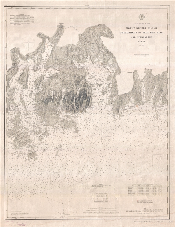
Coast Chart No. 103 Mount Desert Island Frenchman's and Blue Hill Bays and Approaches Maine.
1883 (dated) 40 x 30 in (101.6 x 76.2 cm) 1 : 80000
1883 (dated) 40 x 30 in (101.6 x 76.2 cm) 1 : 80000
Description
A very rare independently issued 1883 (updated to 1895) U.S. Coast and Geodetic Survey nautical chart of Mount Desert Island and the adjacent Frenchman Bay and Blue Hill Bay. The map covers from North Sedgwick eastward as far as Pigeon Hill Bay, and from Ellsworth to the light on Mount Desert Rock and Columbia Ledge. Nearby Swan Island, Long Island, Black Island, and Placentia Island, among others, are included. The map, while primarily a nautical chart, is exquisitely detailed throughout, showing significant inland deal with regard to topography and even the placement of individual buildings. There are countless depth soundings throughout. In the lower right hand quadrant there are noted on light houses, buoys, tides, Soundings, and other information important to the mariner.
The initial triangulation work for this map began in 1856 under A. D. Bache. It was updated and revised in 1875. The topography was completed between 1862 and 1881. The hydrography was done between 1867 and 1882. Additional astronomical and magnetic observations were completed in 1856. This chart was first issued in 1883. The present example bears a stamp in the lower left margin suggested it was updated to 1895. This map is a used sailing chart and bears the tell-tail signs of that use. It is notably on thick stock and was issued independently. This map is rare with no record on the market in recent history.
The initial triangulation work for this map began in 1856 under A. D. Bache. It was updated and revised in 1875. The topography was completed between 1862 and 1881. The hydrography was done between 1867 and 1882. Additional astronomical and magnetic observations were completed in 1856. This chart was first issued in 1883. The present example bears a stamp in the lower left margin suggested it was updated to 1895. This map is a used sailing chart and bears the tell-tail signs of that use. It is notably on thick stock and was issued independently. This map is rare with no record on the market in recent history.
Cartographer
The Office of the Coast Survey (1807 - present) founded in 1807 by President Thomas Jefferson and Secretary of Commerce Albert Gallatin, is the oldest scientific organization in the U.S. Federal Government. Jefferson created the "Survey of the Coast," as it was then called, in response to a need for accurate navigational charts of the new nation's coasts and harbors. The spirit of the Coast Survey was defined by its first two superintendents. The first superintendent of the Coast Survey was Swiss immigrant and West Point mathematics professor Ferdinand Hassler. Under the direction of Hassler, from 1816 to 1843, the ideological and scientific foundations for the Coast Survey were established. These included using the most advanced techniques and most sophisticated equipment as well as an unstinting attention to detail. Hassler devised a labor intensive triangulation system whereby the entire coast was divided into a series of enormous triangles. These were in turn subdivided into smaller triangulation units that were then individually surveyed. Employing this exacting technique on such a massive scale had never before been attempted. Consequently, Hassler and the Coast Survey under him developed a reputation for uncompromising dedication to the principles of accuracy and excellence. Unfortunately, despite being a masterful surveyor, Hassler was abrasive and politically unpopular, twice losing congressional funding for the Coast Survey. Nonetheless, Hassler led the Coast Survey until his death in 1843, at which time Alexander Dallas Bache, a great-grandson of Benjamin Franklin, took the helm. Bache was fully dedicated to the principles established by Hassler, but proved more politically astute and successfully lobbied Congress to liberally fund the endeavor. Under the leadership of A. D. Bache, the Coast Survey completed its most important work. Moreover, during his long tenure with the Coast Survey, from 1843 to 1865, Bache was a steadfast advocate of American science and navigation and in fact founded the American Academy of Sciences. Bache was succeeded by Benjamin Pierce who ran the Survey from 1867 to 1874. Pierce was in turn succeeded by Carlile Pollock Patterson who was Superintendent from 1874 to 1881. In 1878, under Patterson's superintendence, the U.S. Coast Survey was reorganized as the U.S. Coast and Geodetic Survey (C & GS) to accommodate topographic as well as nautical surveys. Today the Coast Survey is part of the National Oceanic and Atmospheric Administration or NOAA as the National Geodetic Survey. More by this mapmaker...
Condition
Good. A couple of closed tears at bottom of map, repaired on verso. Some minor toning and wear related to shipboard use. Else a very nice.
References
OCLC 317743382.