This item has been sold, but you can get on the Waitlist to be notified if another example becomes available, or purchase a digital scan.
1688 Coronelli Globe Gore Map of NE North America, the West Indies, and NE South America
NEAmericaGore-coronelli-1688$1,400.00

Title
New England, the West Indies, Northeastern South America (Unitled Globe Gore).
1688 (undated) 18.25 x 11.5 in (46.355 x 29.21 cm)
1688 (undated) 18.25 x 11.5 in (46.355 x 29.21 cm)
Description
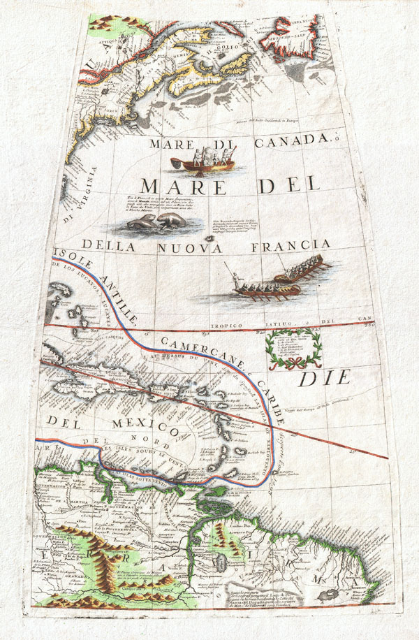
A fine example of Vincenzo Coronelli's extremely rare 1688 globe gore of Eastern America. Covers from Newfoundland south along the New England and Virginia coastlines to the Bahamas (Gigante) and the West Indies, showing parts of Cuba and all of Hispaniola, Porto Rico and the Lesser Antilles, as well as the northern parts of South America from modern day Venezuela to the Orinoco Delta and the Guianas.
As Royal Cartographer to King Louis XIV of France, Coronelli had access to the most recent cartographic records coming from the New World – particularly form the French occupied territories in North America and the West Indies. Advocating French control of much of North America, Coronelli limits New England (Nuoua Inghilterra) to the regions immediately surrounding Cape Cod and Boston Harbor. Similarly, New York (Nuoua Iorck) is confined to the coastal lands near New York City, Connecticut and Long Island. Though largely supplemented by the British by the time Coronelli drew this map, he recognizes Sweden's claims to New Sweden (Nuoua Suecia) in the vicinity of Delaware Bay. The West Indies are drawn with considerable accuracy with notations for cities, ports, islands, and references to the powers that controlled them. Offers good though somewhat inaccurate detail of South America's mountain and river systems, particularly the Orinoco.
Additionally, this map also shows several important sailing routes including both northern and southern routes to Europe. Decorated by several vignettes including cod fishermen off the coast of New England, frolicking Mentees, and two rowboats plying the Atlantic. Also depicts many of the important cod fishing banks between Cape Cod and Newfoundland.
This beautiful gore was originally drawn by Coronelli as part of his fantastic 42 inch 'Terresterial Globe.' Several examples of this magnificent globe are prized today by institutional collections in Europe and America. Far rarer are the atlases that Coronelli published from his globe gores. The Libro Dei Globi, published in 1693 and again in 1701, is the first and likely the finest example of a world atlas composed entirely of globe gores. Only seven complete examples of this rare atlas are known to have survived to modern times.
Cartographer
Vincenzo Maria Coronelli (August 16, 1650 - December 9, 1718) was an important 17th-century cartographer and globe maker based in Venice. Coronelli was born the fifth child of a Venetian tailor. Unlikely to inherit his father's business, he instead apprenticed in Ravenna to a woodcut artist. Around 1663, Coronelli joined the Franciscan Order and, in 1671, entered the Venetian convent of Saint Maria Gloriosa dei Frari. Coronelli excelled in the fields of cosmography, mathematics, and geography. Although his works include the phenomenal Atlante Veneto and Corso Geografico, Coronelli is best known for his globes. In 1678, Coronelli was commissioned to make his first major globes by Ranuccio II Farnese, Duke of Parma. Each superbly engraved globe was five feet in diameter. Louis IV of France, having heard of the magnificent Parma globes, invited Coronelli to Paris, where from 1681-83 he constructed an even more impressive pair of globes measuring over 12 feet in diameter and weighing 2 tons each. The globes earned him the patronage of Louis XIV and privileged access to French cartographic information from Jesuit sources in the New World, particularly Louisiana. Coronelli returned to Venice and continued to publish globes, maps, and atlases, which were admired all over Europe for their beauty, accuracy, and detail. He had a particular fascination for the Great Lakes region, and his early maps of this area were unsurpassed in accuracy for nearly 100 years after their initial publication. He is also well known for his groundbreaking publication of the first accurate map depicting the sources of the Blue Nile. At the height of his career, Coronelli founded the world's first geographical society, the Accademia Cosmografica degli Argonauti, and was awarded the official title Cosmographer of the Republic of Venice. In 1699, in recognition of his extraordinary accomplishment and scholarship, Coronelli was also appointed Father General of the Franciscan Order. The great cartographer and globe maker died in Venice at the age of 68. His extraordinary globes can be seen today at the Bibliothèque Nationale François Mitterrand in Paris, Biblioteca Marciana in Venice, the National Library of Austria, the Globe Museum in Vienna, the Library of Stift Melk, the Special Collections Library of Texas Tech University, as well as lesser works in Trier, Prague, London, and Washington D.C. Coronelli's work is notable for its distinctive style, which is characterized by the high-quality white paper, dark intense impressions, detailed renderings of topographical features in profile, and numerous cartographic innovations. More by this mapmaker...
Source
Coronelli, V., Libro dei Globi, (Venice) 1693.
Coronelli firmly established his reputation as a globe maker in 1683 when he created an astonishing pair of enormous manuscript globes for Louis XIV of France. These measured fifteen feet in diameter and were the largest globes produced to date. (The King declared these to be 'not the least of his ornaments' in Versailles.) Basking in his success - for which he was awarded a fifteen-year privilege - Coronelli was quick to produce a printed 3 1/2 foot terrestrial and celestial globe pair for sale to the public. The 1688 globes were the largest printed globes to date, and Coronelli considered them to be his greatest work in print. He was not without justification. Their superb engraving and encyclopedic geographic detail, not to mention their great size, set them easily amongst the finest globes produced in the 17th century. Desiring to display the quality of these works to a broader audience, and to challenge any potential competition, Coronelli published in 1697 a volume variously titled Libro dei Globi or Palestra Litteraria containing his globe gores. (The title page bore a date of 1693, but the earliest known printing of the book was four years later.) 1697 was busy: Coronelli also included most of the gores from his terrestrial globe among conventional maps in his Atlante Veneto and Isolario that same year. The Libro dei Globi presented the gores of the globes as completely as possible, resulting in considerable overlap but allowing the gores to be viewed consecutively, highlighting their execution as a single work. The gores were employed in the Atlante Veneto as conventional maps. They accompanied the text of the volume, were not shown consecutively, and were not intended to be viewed as a whole. In 1686 Coronelli had contracted with the French engraver Jean Baptiste Nolin to produce an edition of the 3 1/2 foot celestial globe, and several geographical maps. This publication of work through Paris expanded Coronelli's reach as a map publisher and provided the basis for much of his early cartographic output. The terrestrial globe to accompany the celestial was not executed in Paris but in Venice, where Coronelli was able to attract some of the era's finest artists. Augsburg engraver Filipp Kilian provided masterful work on the cartouches. Most of the engraving of the globe was assigned to Alessandro della Via, whose work on the Venice edition of the 1688 celestial globe Coronelli declared superior to that of the Nolin. Shirley enthused:
Even at the time of production, globes were prohibitively expensive to produce and purchase in comparison with printed books. To compare, the 3 1/2 foot globe pair with stands cost 1240 Venetian Lire in 1697. The first volume of Coronelli's Atlante Veneto was 55.16 Lire. Therefore in order to reach a broader audience with his globes, and to get better return for the expense of producing the copperplate gores, Coronelli produced his Libro dei Globi which - though still tipping the scales at 310 Lire - would bring the magnificent engraving and detail of his work to those unwilling or unable to cough up twice as much for a single globe. It included the gores of all of Coronelli's globes - though a buyer hoping to construct the largest of these globes with the gores therein would have been sorely disappointed. The format of the books would not allow for the printing of the full-length gores of the 3 1/2 foot globe, which were therefore printed with portions masked off. Since this process did not change the plates, but merely obscured the parts which were not to be printed, it meant that different parts of the same gore could be chosen for different printings. This becomes significant when addressing the specific source of one or another of these bound gores: those printed in the Libro dei Globi shared consistent latitudes, and thus could be easily arranged consecutively and read as they might be on a globe. The same gores printed in Coronelli's 1697 Isolario did not necessarily share that consistency. For that matter, different copies of the Libro dei Globi itself likely contained different maskings of the same gores. Studies of the book - of which there are but a dozen copies identified - show them to be made-to-order volumes with great variation in the inclusion of supplemental materials. No two are identical. It should be rembered that none of the books were intended for the production of a globe, or to replace one: As Scianna points out:
The engraving and design throughout is of the highest standard with neat contrasting lettering and five large cartouches of singular grace and elegance... Coronelli seems to have sought to omit nothing that might be of interest to geographers, navigators, and explorers. There are an unusual number of legends, all explanatory and informative, but which never crowd the space available. Many of the vignettes of ships and fishing scenes throughout the world are worthy of separate reproduction.Complete sets of these gores are to be found in the British Library and the Library of Congress: they are of extraordinary rarity.
Even at the time of production, globes were prohibitively expensive to produce and purchase in comparison with printed books. To compare, the 3 1/2 foot globe pair with stands cost 1240 Venetian Lire in 1697. The first volume of Coronelli's Atlante Veneto was 55.16 Lire. Therefore in order to reach a broader audience with his globes, and to get better return for the expense of producing the copperplate gores, Coronelli produced his Libro dei Globi which - though still tipping the scales at 310 Lire - would bring the magnificent engraving and detail of his work to those unwilling or unable to cough up twice as much for a single globe. It included the gores of all of Coronelli's globes - though a buyer hoping to construct the largest of these globes with the gores therein would have been sorely disappointed. The format of the books would not allow for the printing of the full-length gores of the 3 1/2 foot globe, which were therefore printed with portions masked off. Since this process did not change the plates, but merely obscured the parts which were not to be printed, it meant that different parts of the same gore could be chosen for different printings. This becomes significant when addressing the specific source of one or another of these bound gores: those printed in the Libro dei Globi shared consistent latitudes, and thus could be easily arranged consecutively and read as they might be on a globe. The same gores printed in Coronelli's 1697 Isolario did not necessarily share that consistency. For that matter, different copies of the Libro dei Globi itself likely contained different maskings of the same gores. Studies of the book - of which there are but a dozen copies identified - show them to be made-to-order volumes with great variation in the inclusion of supplemental materials. No two are identical. It should be rembered that none of the books were intended for the production of a globe, or to replace one: As Scianna points out:
If Coronelli really wanted to collect all the prints he used for the gores of his globes in a single book, he would have to realize a volume of 180-184 plates, whereas no copy has that many. The most extensive copy is the one kept in Yale that has 167 plates; therefore even in this copy several plates are omitted.As alluded to above, Coronelli's Isolario would see the mapmaker again employing the terrestrial globe gores - not as a representation of a complete globe, but as illustrative maps in a broader geographical text accompanied by conventional maps, views, and diagrams. The plates for the globe were approximately six inches too long to fit the format in which his books would be printed, so for the books Coronelli had the plates masked off at one end or the other to restrict the printed image to the half-folio sheets, and occasionally even smaller portions for insertion to the text. For most of the gores, Coronelli chose to mask the portions closest to the poles and to have the sheets centered on the tropics. In specific cases, he instead chose to present the areas ending at the Arctic or Antarctic circles, generally when there were features he wished to highlight: Hudson's Bay, for example, or Tierra del Fuego. The publication of the Libro dei Globi appears to have spanned both sides of the printing of the Isolario. A number of these - which seem to date as late as 1705 - bear the title Palestra Litteraria. This translates roughly to 'Literary Gymnasium' but Dr. Helen Wattis rendered it as 'Literary Wrestling Match' to capture the spirit in which the book was produced. Coronelli presented the work as a direct challenge to any cartographer, geographer, or astronomer to 'criticize or to compare with any other globe, the globes of Coronelli.' A modern rendition of 'Literary Throwdown' might not be amiss.
Condition
Near flawless. Wide clean margins. Orignal pressmark visible. Blank on verso.
References
Wallis, H., Theatrum Orbis Terrarum, series of Atlases in Facimile, Vol. IV, introduction. Boston Public Library, Norman Leventhal Map Center, (call number).