This item has been sold, but you can get on the Waitlist to be notified if another example becomes available, or purchase a digital scan.
1895 Bien Map of New York City (w/ Queens & the Bronx)
NYC-bien-1895$175.00

Title
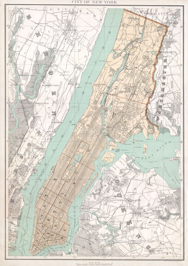
City of New York.
1895 (undated) 24 x 16.5 in (60.96 x 41.91 cm)
1895 (undated) 24 x 16.5 in (60.96 x 41.91 cm)
Description
A beautiful 1895 large format map of New York City by Julius Bien. Depicts the borough of Mahattan, Queens, and the Bronx as far as Yonkers and Westchester. Features good detail of the streets, trains, and parks as well as ferry routes and piers. Bien's Atlas of New York was issued as an elephant folio and there is consequently no centerfold. Prepared for inclusion in the 1895 edition of Juliue Bien's Atlas of New York State.
Cartographer
Julius (Julien) Bien (September 27, 1826 - December 21, 1909) was a German-Jewish lithographer and engraver based in New York City. Bien was born in Naumburg, Germany. He was educated at the Academy of Fine Arts, Cassell and at Städel's Institute, Frankfurt-am-Main. Following the suppression of the anti-autocratic German Revolutions of 1848, Bien, who participated in the pan-German movement, found himself out of favor in his home country and joined the mass German immigration to the United States. Bien can be found in New York as early as 1849. He established the New York Lithographing, Engraving & Printing Company in New York that focused on the emergent chromo-lithograph process - a method of printing color using lithographic plates. His work drew the attention of the U.S. Government Printing Office which contracted him to produce countless government maps and surveys, including the Pacific Railroad Surveys, the census, numerous coast surveys, and various maps relating to the American Civil War. Bien also issued several atlases both privately and in conjunction with a relation, Joseph Bien. At the height of his career Bien was elected president of the American Lithographers Association. After his death in 1909, Bien's firm was taken over by his son who promptly ran it into insolvency. The firm was sold to Sheldon Franklin, who, as part of the deal, retained the right to publish under the Julius Bien imprint. In addition to his work as a printer, Bien was active in the New York German Jewish community. He was director of the New York Hebrew Technical Institute, the New York Hebrew Orphan Asylum, and president of the B'nai B'rith Order. More by this mapmaker...
Condition
Very Good Condition. Blank on verso.
References
Phillips (Atlases) 2211. Nestler, H. A Bibliography of New York State Communities (3rd ed.), p. 107. LeGear, Atlases of the United States, L2401. Phillips (America), p. 518. Creek, B., Maps of the Genesee Valley & Finger Lakes Region, p. 70. Rumsey 0071.007.