1945 Army Map Service Map of Nagasaki, Japan - Printed in August 1945
NagasakiPreliminary-ams-1945$1,200.00

Title
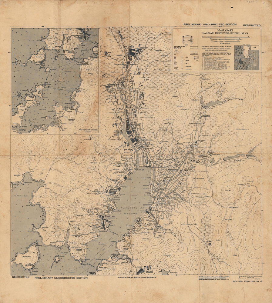
Nagasaki. Nagasaki Prefecture, Kyushu, Japan. Preliminary Uncorrected Edition. Restricted.
1945 (dated) 19.25 x 18.75 in (48.895 x 47.625 cm) 1 : 18000
1945 (dated) 19.25 x 18.75 in (48.895 x 47.625 cm) 1 : 18000
Description
This is a 1945 Army Map Service map of Nagasaki, Japan, printed just days before the dropping of Fat Man. The map was initially created for the U.S. Army Air Force's continued aerial campaign against the home islands, but, significantly, this is the most up-to-day map the U.S. Army had of Nagasaki before the August 9, 1945 nuclear bombing that devastated the city and an example would certainly have been on Bockscar, and its reconnaissance planes when the bombing occurred.
A Closer Look
The city is illustrated as it appeared before the August 9, 1945, nuclear attack. Buildings throughout are identified. Schools and Buddhist shrines (marked by swastikas per Japanese tradition) appear throughout alongside factories, dry docks, and naval bases. Law courts and consulates are labeled, along with the Red Cross building. A Catholic Church is even identified. An inset in the upper right details Nagasaki Harbor and includes depth soundings and navigation lights.Bombing of Nagasaki
On August 9, 1945 the United States dropped the atomic bomb 'Fat Man' on Nagasaki. Its detonation unleashed a cataclysmic blast that devastated Nagasaki, resulting in the obliteration of structures, widespread fires, and the loss of tens of thousands of lives. The decision to drop a second atomic bomb followed just three days after the bombing of Hiroshima on August 6, 1945. Of interest, Nagasaki was a secondary target, as 'Fat Man' was initially intended for Kokurka, at the northern tip of Kyushu, but conditions and mis-management of the mission, forced Bockscar crew to retarget mid-mission (for more, see our item Kyushu-69thengrtopoco-1945). Nagasaki's hilly terrain partially shielded some areas from the full impact of the blast, but the destruction was still extensive. The bombing played a pivotal role in hastening Japan's surrender in World War II (1939 - 1945). The Japanese government, already grappling with the devastation of Hiroshima, recognized the unprecedented destructive power of these new weapons and the futility of continuing the war. Consequently, Japan formally surrendered on August 15, 1945, marking the end of World War II. Beyond its immediate military and strategic implications, the Nagasaki bombing had profound and lasting effects on the world. It marked the dawn of the nuclear age and raised profound ethical, moral, and political questions about the use of atomic weapons.Provenance
This map was acquired from the collections of U.S. Military Museum of Danbury, a private museum owned by John Valluzzo that closed in 2016 after his untimely death.Publication History and Census
This map was compiled by the Army Map Service in Washington, D.C. in February 1944 and printed by the 650th Engineer Battalion in August 1945 for use in the Army Air Forces Objective Folder for Sasebo, Japan. The map still bears pencil notations in the upper margin noting its numerical designation within that folder. This is the only known surviving example of the present map in the pre-nuclear bombing edition. We note only two other cataloged maps bearing the notation 'Preliminary Uncorrected Edition. Restricted'. One is a map of Kyoto at Yale University, also created as part of an Army Air Force Air Objective Folder. The other is a Nagasaki City Map that was cataloged as being part of the records of the United States Strategic Bombing Survey in June 1947. Today the records of the Strategic Bombing Survey are at the National Archives, which means it may be there. However, the National Archives has not digitized an inventory of the Strategic Bombing Survey records.Cartographer
The Army Map Service (AMS) (1941 - 1968) was the military cartographic agency of the U.S. Department of Defense and part of the U.S. Army Corps of Engineers. The AMS compiled, published, and distributed military topographical maps and other related materials for use by the U.S. Armed Forces. They also prepared maps for space exploration, intelligence reports, and the establishment of world geodetic control networks. Formed during World War II, by the end of the war the Army Map Service had prepared 40,000 maps. 3,000 different maps were created for the Normandy invasion alone. The AMS was instrumental in the Korean War and the Vietnam War, and during all three of these conflicts distributed tens of millions of maps to U.S. servicemen. On September 1, 1968, the AMS was resdesignated the U.S. Army Topographic Command, and continued under this name as an independent organization until January 1, 1972 when it was merged with the new Defense Mapping Agency and renamed the DMA Topographic Center. The Defense Mapping Agency was added to the National Imagery and Mapping Agency on October 1, 1996, which was redesigned the National Geospatial-Intelligence Agency in 2003. More by this mapmaker...
Condition
Good. Wear along original fold lines. Soiling.