
Army Map Service
The Army Map Service (AMS) (1941 - 1968) was the military cartographic agency of the U.S. Department of Defense and part of the U.S. Army Corps of Engineers. The AMS compiled, published, and distributed military topographical maps and other related materials for use by the U.S. Armed Forces. They also prepared maps for space exploration, intelligence reports, and the establishment of world geodetic control networks. Formed during World War II, by the end of the war the Army Map Service had prepared 40,000 maps. 3,000 different maps were created for the Normandy invasion alone. The AMS was instrumental in the Korean War and the Vietnam War, and during all three of these conflicts distributed tens of millions of maps to U.S. servicemen. On September 1, 1968, the AMS was resdesignated the U.S. Army Topographic Command, and continued under this name as an independent organization until January 1, 1972 when it was merged with the new Defense Mapping Agency and renamed the DMA Topographic Center. The Defense Mapping Agency was added to the National Imagery and Mapping Agency on October 1, 1996, which was redesigned the National Geospatial-Intelligence Agency in 2003.
Enabling the armed services vote during WWII.
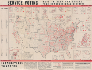
Service Voting. Maps to Help You Locate Your Congressional District.
$2,000.00
Acquire
- Digital Map Information
- Suitable for large format printing
- Full resolution TIFF file
- ICC color profile embedded
- Delivered instantly via download link
This is a 1944 Army Map Service map of the United States created to direct U.S. service personnel to their congressional district. The map reflects a broad effort during World War II (1939 - 1945) to help actively servering soliders cast their votes in the 1944 Presidental Election. (more details)
A detailed road map of Luzon created the year before Allied forces began retaking the island from the Japanese.
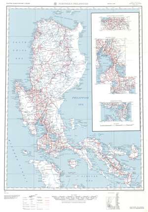
Northern Philippines.
$300.00
Acquire
- Digital Map Information
- Suitable for large format printing
- File Size: 47.38 MB
- File Type: ZIP / TIFF
- ICC color profile embedded
- Delivered instantly via download link
This is a 1944 Army Map Service road map of northern Luzon in the Philippines. The map depicts the region from the South China Sea and the Mindoro Strait to Cataduanes Island and from Fuga Island and Camiguin Island to Mindoro and the Sibuyan Sea. Roads throughout the region are highlighted in red and are not limited to Luzon alone. Roads of varying grades are also differentiated, with thick red lines denoting 'surfaced, all-weather, regularly maintained' roads, while 'partly surfaced, dry-weather' roads are marked by solid and white dashed lines. Not surfaced roads are illustrated by two thin parallel red lines, while a thin solid red lines mark tracks. Trails are noted by thin dashed lines.
Cities and towns throughout the region are labeled, including Manila, Pasay, and Lingayen. Bays, gulfs, points, and peninsulas all along the coast are identified as well, as are the myriad small islands surrounding Luzon. Three insets situated along the right border highlight Lingayen and the immediate vicinity, Manila Bay, and Sorsogon Bay. A small index map situated below the bottom border illustrates and identifies all thirty-three provinces depicted here. (more details)
Cities and towns throughout the region are labeled, including Manila, Pasay, and Lingayen. Bays, gulfs, points, and peninsulas all along the coast are identified as well, as are the myriad small islands surrounding Luzon. Three insets situated along the right border highlight Lingayen and the immediate vicinity, Manila Bay, and Sorsogon Bay. A small index map situated below the bottom border illustrates and identifies all thirty-three provinces depicted here. (more details)
Identifies many major islands in the archipelago, including Mindanao, Leyte, Cebu, Negros, and Panay.
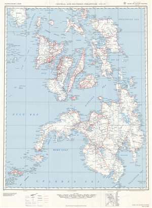
Central and Southern Philippines.
$300.00
Acquire
- Digital Map Information
- Suitable for large format printing
- File Size: 74.08 MB
- File Type: ZIP / TIFF
- ICC color profile embedded
- Delivered instantly via download link
This is a 1944 Army Map Service map of the central and southern Philippines. The map depicts the region from the Mindoro Strait to Mindanao and the Philippine Sea and from Luzon and Mindoro to the Celebes Sea and the Sulu Archipelago. Created as a road map for U.S. and Allied armed forces, bright red lines highlight the 'surface, all-weather, regularly maintained roads throughout the illustrated islands. Other depicted roads decline in grade, from those that are only partly surfaced and could be relied upon only in dry weather to simple trails, are identified by different symbols which are explained in detail in a legend situated along the bottom border. Roads that were under construction as of 1941 are marked by two parallel dashed lines. Apart from the roads, myriad cities, towns, and villages are labeled throughout, with many of the smallest islands not having any identified settlements. Seas, straits, passages, gulfs, and sounds are all identified as well with blue block lettering. (more details)
Last Days of Japan's Occupation of Hong Kong
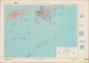
Hong Kong and Lema Islands. South Sheet. Second Edition - AMS 3.
$1,500.00
Acquire
- Digital Map Information
- Suitable for large format printing
- Full resolution TIFF file
- ICC color profile embedded
- Delivered instantly via download link
This is a 1945 Army Map Service map of Hong Kong, produced in the closing days of World War II. By this time, Hong Kong had suffered through nearly four years of starvation and oppression under Japanese occupation. (more details)
Most up-to-date military map of Nagasaki on the even of the Atomic Bombing.
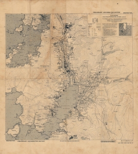
Nagasaki. Nagasaki Prefecture, Kyushu, Japan. Preliminary Uncorrected Edition. Restricted.
$1,200.00
Acquire
- Digital Map Information
- Suitable for large format printing
- File Size: 26.38 MB
- File Type: ZIP / TIFF
- ICC color profile embedded
- Delivered instantly via download link
This is a 1945 Army Map Service map of Nagasaki, Japan, printed just days before the dropping of Fat Man. The map was initially created for the U.S. Army Air Force's continued aerial campaign against the home islands, but, significantly, this is the most up-to-day map the U.S. Army had of Nagasaki before the August 9, 1945 nuclear bombing that devastated the city and an example would certainly have been on Bockscar, and its reconnaissance planes when the bombing occurred. (more details)
Investigating the damage done by the atomic bombs.
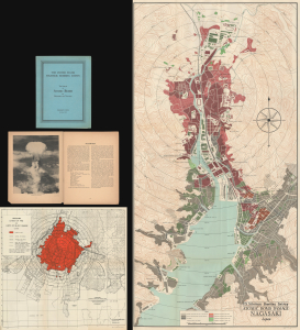
The United States Strategic Bombing Survey. The Effects of the Atomic Bombs on Hiroshima and Nagasaki. / U.S. Strategic Bombing Survey Atomic Bomb Damage Nagasaki Japan. / Hiroshima Extent of Fire and Limits of Blast Damage.
$1,500.00
Acquire
This is the 1946 United States Strategic Bombing Survey report on the effects of the atomic bombs on Hiroshima and Nagasaki at the end of World War II (1939 - 1945). Two maps depict Hiroshima and Nagasaki, respectively, and detail the damage wrought on the cities by the bombs. The report details these catastrophic events in a cold, administrative manner. However, the photographs included make the reality of the destruction abundantly clear. (more details)
Safeguarding Saudi Arabia's Main Oil Port.
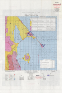
Tactical Commanders' Terrain Analysis Ras Tanura Area Terrain Analysis Map AP-1-380-46-65-INT. TacCTA Ras Tanura Saudi Arabia.
$1,500.00
Acquire
This is a 1965 Tactical Commanders' Terrain Analysis (TacCTA) map of Ras Tanura, Saudi Arabia, prepared by the Army Map Service for the Defense Intelligence Agency. The area is home to a large Saudi Aramco oil refinery and port, the main avenue for Saudi Arabia's oil exports, and the map would have been vital for any military operation that might take place there. (more details)