
This item below is out of stock, but another example (left) is available. To view the available item, click "Details."
Details
1946 Sutton / Miller Pictorial Map of Nantucket, in its third edition of 1980
1980 (dated) $850.00
1946 Sutton - Miller Pictorial Map of Nantucket, in its second edition of 1964
Nantucket-sutton-1964-2$750.00

Title
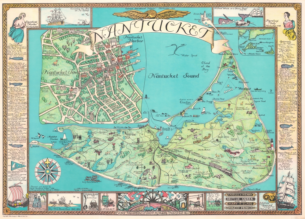
Nantucket.
1964 (dated) 22.25 x 31 in (56.515 x 78.74 cm) 1 : 31680
1964 (dated) 22.25 x 31 in (56.515 x 78.74 cm) 1 : 31680
Description
This is a beautiful example of the 1964 edition of Ruth Haviland Sutton’s pictorial map of Nantucket, Massachusetts. This vivacious depiction of the island emphasizes its nautical history and character. Its execution reflects the love of place that led Sutton to relocate there for most of her adult life. The waters around the island are decorated with boats and ships – some native, some European, some afloat but many shipwrecked (these last have the dates).
Monuments and lighthouses are marked and dated. The Nantucket Central Railroad is illustrated, with its dates of operation (1881 - 1917). The railroad’s sole engine, Dionis, is named. (The whole railway was torn up and sent to France to aid the Allies in World War I.) A horse-drawn rail carriage running between Nantucket Town and the Bathing Beach is given its dates (1890-1892). Fish and waterfowl appear in the surrounding waters, and flowers characteristic to different parts of the island are pictured and named, along with forests and cranberry bogs.
Capturing the Past for Posterity
The map is not just a depiction of the Nantucket of 1946. It is meant to preserve the history of the island. Many details are those that Sutton would have been personally familiar with, still more would have survived in local memory, and all would have been the argot of Nantucket locals. Not only the shipwrecks, but many other details are dated. No doubt as familiar to locals the catboat Lillian, shown in Nantucket Harbor with her dates (1876 - 1932). She carried freight and passengers between villages on Nantucket Harbor. She would have been both familiar to and mourned by the locals who relied on her.Monuments and lighthouses are marked and dated. The Nantucket Central Railroad is illustrated, with its dates of operation (1881 - 1917). The railroad’s sole engine, Dionis, is named. (The whole railway was torn up and sent to France to aid the Allies in World War I.) A horse-drawn rail carriage running between Nantucket Town and the Bathing Beach is given its dates (1890-1892). Fish and waterfowl appear in the surrounding waters, and flowers characteristic to different parts of the island are pictured and named, along with forests and cranberry bogs.
Nantucket Town
A detailed inset plan of Nantucket Town occupies most of the upper left quadrant, naming the streets and important structures, many of which are numbered and keyed to a list included within the right border. Buildings are illustrated pictorially, capturing the character of the town’s architecture but also giving an impression of tree-lined streets and generous lawns.Border Vignettes
The pictorial border again emphasizes Nantucket’s history, with pictures of literary and historical events in addition to lists of businesses and hotels. A historical timeline reaching back to the first possible European sightings of the island is appended as well. The title is inscribed on an unfurled banner borne by an eagle in flight, lending a patriotic note to the composition. An illustration of the carved stern of the Edgartown whaling ship Eunice H. Adams appears in the lower center. Ships and ships’ figureheads decorate the corners (puzzlingly, one of these is a Viking longship, though there is here appended no date).Publication History and Census
Sutton composed and painted this map in 1946, to be printed by George C. Miller that year. This first edition, which we find cataloged only in the University of Connecticut, the University of Illinois, and Stanford University Library, was printed both in two sizes, 22 x 31 inches and 19.25 x 25.5 inches. In 1964, a second edition was printed under the ‘George C. Miller and Son, Inc.’ imprint, only in the larger iteration. This second edition (present example) is not cataloged in OCLC. Miller’s Son, Burr, would go on to produce a third edition of the map in 1980, again reproducing only the larger format of the map. All three editions are scarce to the market.CartographerS
Ruth Haviland Sutton (September 10, 1898 - November 23, 1960) was an American printmaker, pastel portraitist, and oil painter. She was born in Springfield, Massachusetts and began her training as an artist at Philadelphia's Pennsylvania Museum and School of the Arts starting in 1924. (That year would also see her first visit to Nantucket, where she visited in order to study with Frank S. Chase, under whose tutelage she became an accomplished painter.) She also studied at Grand Central School of Art in New York City, and with Jerry Farnsworth in Florida. She studied printmaking with George C. Miller in New York and attended the Art Students League in New York City to learn drawing and anatomy from George Bridgman and sculpture from Mahonri Young. As a working, professional artist, she received commissions in the 1930s from the Works Progress Administration to paint murals at the Museum of Natural History in her hometown - before she relocated permanently to Nantucket. There, she applied her lithographic skills to decorative prints of Nantucket scenes, which she published and sold as a series of printed postcards. Her work also included a famous pictorial map of Nantucket and a montage of Nantucket attractions. Sutton was a founding member of The Boston Printmakers and was active in the Springfield Artists Guild and the Springfield Art League. She became one of the most active artists, and ardent promoters, of the Nantucket Art Colony, and shared her success with other artists by purchasing, refurbishing, and affordably renting four waterfront properties to artists. She died - in Nantucket - on November 23, 1960. More by this mapmaker...
George Charles Miller (June 17, 1894 - October 21, 1965) was an American lithographer and publisher. He was born in New York City into a commercial printing family, and began his apprenticeship in the family business at 15. He completed his apprenticeship at the American Lithographic Company. Miller served in World War I. He is notable for having recognized early on the value of printing for artists, and would eventually print exclusively for artists: one of only a few American printers to do so. Not only did he print artists' work, but he also trained artists (Ruth Haviland Sutton among them) in the craft of lithography. He was married to Carrie Scharsmith Miller, and lived most of his life in Lynbrook, Long Island, New York. He also had a home in Burlington, Vermont, where he died of a heart attack in 1965. Miller's son, Burris G. Miller (1928 - 2017) took over the business, until retiring in 1994. Learn More...
Condition
Very good.
References
Rumsey 7980.000 (1946). OCLC 953572717 (1946).