1730 Homann Map of Southern Italy
Neapolis-homann-1730$750.00
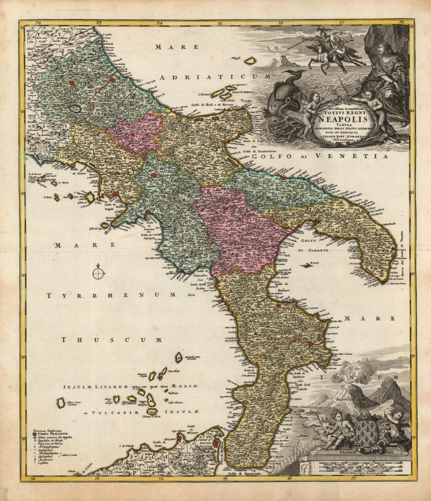

Title
Novissima et exactissima Totius Regni Neapolis Tabula Praesentis Belli Statui Accomodata et Exhibita.
1730 (undated) 22.75 x 19.75 in (57.785 x 50.165 cm) 1 : 1100000
1730 (undated) 22.75 x 19.75 in (57.785 x 50.165 cm) 1 : 1100000
Description
This is a beautiful 1730 old-color example of Johann Baptist Homann's map of the Kingdom of Naples, then most of southern Italy. The map was issued to illustrate this theater of the War of the Spanish Succession (1701 - 1714), thus covering from Terracina to the Adriatic Sea and northern Sicily.
Andromeda was the daughter of the Ethiopian king and queen Cepheus and Cassiopeia. The vain Cassiopeia boasted of being more beautiful than Juno (Hera), queen of the gods. The vengeful goddess had Neptune send the sea monster Cetus to menace the Ethiopian coast - until, to appease Neptune, Cepheus was forced to sacrifice his beautiful virgin daughter, Andromeda, to Cetus by chaining her (naked!) to rocks on the shore. Perseus, passing by, notices the beautiful girl and makes a deal with her parents that he will save her if he is given her hand in marriage. The king and queen agree.
There may have been a cautionary element as well. While some depictions of Perseus and Andromeda in 16th and 17th-century art depict scenes much like this one, some depict Perseus plummeting headlong into the waves after Pegasus, stung by a fly sent by the jealous gods, threw the hero off his back. The classically educated audience for this map would have been well aware of all the parts of the myth as they applied.
Another beautifully engraved cartouche embellishing the map's scales appears at the bottom right. Here, the arms of the Kingdom of Naples are flanked by two more putti; one also brandishes a sword, but the other points, with some alarm, at the violently erupting Mount Vesuvius.
Pregnant With Allegory
The map's title describes the map as 'adapted and presented to the current war'; nowhere on the map are these adaptations so present as they are in the magnificent allegorical title cartouche. The theme of the scene was famous and would have been familiar to the map's literate European audience: the myth of Perseus and Andromeda.Andromeda was the daughter of the Ethiopian king and queen Cepheus and Cassiopeia. The vain Cassiopeia boasted of being more beautiful than Juno (Hera), queen of the gods. The vengeful goddess had Neptune send the sea monster Cetus to menace the Ethiopian coast - until, to appease Neptune, Cepheus was forced to sacrifice his beautiful virgin daughter, Andromeda, to Cetus by chaining her (naked!) to rocks on the shore. Perseus, passing by, notices the beautiful girl and makes a deal with her parents that he will save her if he is given her hand in marriage. The king and queen agree.
The Allegory
In this iteration of 'Perseus and Andromeda,' Andromeda is modestly and sumptuously dressed and wears a crown. She is a regal figure and, in this context, almost certainly represents the Kingdom of Naples. Perseus, astride Pegasus, is carrying a shield bearing the arms of Charles VI, the Holy Roman Emperor; so Perseus here is the Empire. The monster Cetus roils the waves, while in the background, an island volcano - possibly Stromboli - fumes. Flanking the title cartouche, the angriest putti we have ever encountered, lash at each other with swords. Contextually, this represents the War of the Spanish Succession (1701 - 1714). During the war, the Empire seized the Kingdom of Naples from Bourbon Spain and retained the territory in the 1714 Treaty of Rastatt. And so, like Perseus, Charles VI would go to war to 'rescue' Naples - on the condition that she become his possession thereafter.There may have been a cautionary element as well. While some depictions of Perseus and Andromeda in 16th and 17th-century art depict scenes much like this one, some depict Perseus plummeting headlong into the waves after Pegasus, stung by a fly sent by the jealous gods, threw the hero off his back. The classically educated audience for this map would have been well aware of all the parts of the myth as they applied.
Another beautifully engraved cartouche embellishing the map's scales appears at the bottom right. Here, the arms of the Kingdom of Naples are flanked by two more putti; one also brandishes a sword, but the other points, with some alarm, at the violently erupting Mount Vesuvius.
The Crypto-Island of 'M. Sardo'
As authoritative as Magini's 1608 wall map Italia Nuova was, one of its hallmarks was the placement of a mysterious mountainous island, 'M. Sardo', in the Gulf of Taranto. Despite being reproduced faithfully on nearly every 17th-century map of the peninsula, the origins of this imaginary island have long been obscure. More recently, the scholar/collector Vladimirio Valerio discovered a notation on the Otranto map in the 1595 Stigliola manuscript atlas of the Kingdom of Naples (added to his collection in 1975). On that manuscript, a crude mountain-hump is mapped in the Gulf of Taranto - the first known instance in print or otherwise of any such 'M. Sardo' in those waters. While no such island or mountain actually exists, near the tip of Otranto, there is a mountaintop village - Monte Sardo - notable for its visibility both from the Gulf of Otranto and the Gulf of Venice. Thus, the manuscript 'M. Sardo' is a crude coastal profile highlighting an observable coastal navigational feature. Valerio theorizes that, in compiling his masterpiece map of Italy, Magini consulted the Stigliola as the best and most detailed map of southern Italy. In doing so, he misinterpreted the navigational notation, preserving it as a literal mountain in the middle of the Gulf and retaining the name M. Sardo. Magini's work was so authoritative that Blaeu copied the map, errors and all; and in turn, with few exceptions, the rest of the European mapmaking community followed.Publication History and Census
This superb map was derived from Frederic de Wit's 1680 Regnum Neapolis, which in turn was among the maps informed by Giovanni Antonio Magini's monumental Italia Nuova, as is evidenced both by the map's meticulous detail, as well as certain telltale errors. The present map was engraved, possibly by Homann himself, for inclusion in his atlases. It was probably not done prior to 1707 (when the war moved to Naples), and it was certainly completed by 1716 (one of the earliest confirmed dates we see it in a Homann atlas). The present example, which includes the Imperial Privilege, appears sometime between 1724 and 1730 after Homann's death and the firm's passage to his son and is clearly a painstaking re-engraving. We see at least three plate variants: one dating to around 1716 (see Rumsey 12499.089) and another printed by the firm of Homann Heirs well into the 18th century (Rumsey 9753.036). The present example appears to fall between these two. The map is well represented in institutional collections, but with the haphazard dating that characterizes OCLC listings for Homann's maps.Cartographer
Johann Baptist Homann (March 20, 1664 - July 1, 1724) was the most prominent and prolific map publisher of the 18th century. Homann was born in Oberkammlach, a small town near Kammlach, Bavaria, Germany. As a young man, Homann studied in a Jesuit school and nursed ambitions of becoming a Dominican priest. Nonetheless, he converted to Protestantism in 1687, when he was 23. It is not clear where he mastered engraving, but we believe it may have been in Amsterdam. Homann's earliest work we have identified is about 1689, and already exhibits a high degree of mastery. Around 1691, Homann moved to Nuremberg and registered as a notary. By this time, he was already making maps, and very good ones at that. He produced a map of the environs of Nürnberg in 1691/92, which suggests he was already a master engraver. Around 1693, Homann briefly relocated to Vienna, where he lived and studied printing and copper plate engraving until 1695. Until 1702, he worked in Nuremberg in the map trade under Jacob von Sandrart (1630 - 1708) and then David Funck (1642 - 1709). Afterward, he returned to Nuremberg, where, in 1702, he founded the commercial publishing firm that would bear his name. In the next five years, Homann produced hundreds of maps and developed a distinctive style characterized by heavy, detailed engraving, elaborate allegorical cartouche work, and vivid hand color. Due to the lower cost of printing in Germany, the Homann firm could undercut the dominant French and Dutch publishing houses while matching their diversity and quality. Despite copious output, Homann did not release his first major atlas until the 33-map Neuer Atlas of 1707, followed by a 60-map edition of 1710. By 1715, Homann's rising star caught the attention of the Holy Roman Emperor Charles VI, who appointed him Imperial Cartographer. In the same year, he was also appointed a member of the Royal Academy of Sciences in Berlin. Homann's prestigious title came with several significant advantages, including access to the most up-to-date cartographic information as well as the 'Privilege'. The Privilege was a type of early copyright offered to very few by the Holy Roman Emperor. Though less sophisticated than modern copyright legislation, the Privilege offered limited protection for several years. Most all J. B. Homann maps printed between 1715 and 1730 bear the inscription 'Cum Priviligio' or some variation. Following Homann's death in 1724, the firm's map plates and management passed to his son, Johann Christoph Homann (1703 - 1730). J. C. Homann, perhaps realizing that he would not long survive his father, stipulated in his will that the company would be inherited by his two head managers, Johann Georg Ebersberger (1695 - 1760) and Johann Michael Franz (1700 - 1761), and that it would publish only under the name 'Homann Heirs'. This designation, in various forms (Homannsche Heirs, Heritiers de Homann, Lat Homannianos Herod, Homannschen Erben, etc.) appears on maps from about 1731 onwards. The firm continued to publish maps in ever-diminishing quantities until the death of its last owner, Christoph Franz Fembo (1781 - 1848). More by this mapmaker...
Source
Homann, J. B. and Homann, J. C., Neuer Atlas bestehend in einig curieusen Astronomischen Kuppren und vielen auserlesenen accuratensten Land-Charten über die Gantze Welt, (Nuremberg: Homann Heirs), 1730.
Homann's Neuer Atlas bestehend in einig curieusen Astronomischen Kuppren und vielen auserlesenen accuratensten Land-Charten über die Gantze Welt was first publihsed in 1707 with 33 maps. A second edition followed in 1710 with 60 maps. Subsequent editions followed until about 1730. The title page notes proudly that the atlas features measurements based on the 'Copernican principle of the moving sky', a truly state-of-the-art innovation for the period. Regardless of editions, collations of the atlas are inconsistent, with some examples having less, while others have more maps - a consequence of the fact that the map sheets were delivered loose, to be bound at the buyer's discretion, and so some buyers chose to omit maps they did not consider relevant, or add others they did. Between editions, the constituent maps, particularly of European regions, were regularly updated to reflect the most recent political events. The atlas continued to be published by Homann's son, J. C. Homann (1703 - 1730), and then by Homann Heirs. Most examples also feature a fine allegorical frontispiece with the title Atlas Novus Terrarum Orbis Imperia, regna et Status, which was used for multiple Homann atlases, including the Neuer Atlas and the Atlas Minor.
Condition
Very good. Light toning at extremities of margins. Fine original color.
References
OCLC 630883197. cf. Rumsey 12499.089.