1969 Sahayogi Press Map of Nepal
Nepal-sahayogipress-1969$550.00

Title
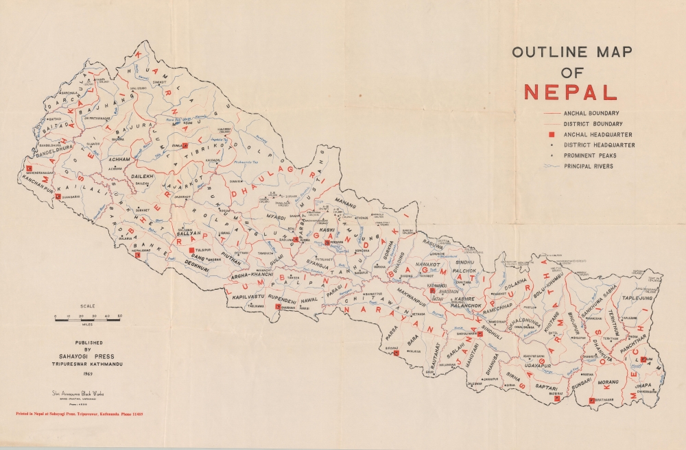
Outline Map of Nepal.
1969 (dated) 19 x 29 in (48.26 x 73.66 cm) 1 : 1100000
1969 (dated) 19 x 29 in (48.26 x 73.66 cm) 1 : 1100000
Description
A scarce, domestically produced map of Nepal, published by the Sahayogi Press in Katmandu in 1969. It presents the country at a moment of transition, as the Panchayat regime instituted in 1961 undertook major social and economic development programs.
A Closer Look
Nepal is displayed as divided into 14 administrative zones (anchal) and 77 districts (jillā). Major cities and towns - anchal and district headquarters or capitals - are noted, along with rivers and mountain peaks with their elevations (including Mt. Everest, known as Sagarmāthā in Nepali and Chomolungma in Tibetan). Unsurprisingly, as the map was published in Nepal, the Nepalese interpretation of a border dispute with India at Susta, the bulge extending southeast of Parasi (now Ramgram), is reflected.The Panchayat Era
The map dates from the early part of the Panchayat era (1961 - 1990), under which King Mahendra dissolved the elected government and undertook large-scale campaigns to promote national unification and development. For example, one of the major projects of the era was the construction of the East-West Highway or Mahendra Highway, linking a string of towns and cities in the southern part of the country. At the time, only a handful of paved roads traversed portions of the steep mountains and dense forests of Nepal, and travel between districts generally required going south into India, then east or west, and then north again into Nepal. Begun at Gaindakot-Bharatpur, southwest of Katmandu, in 1960, the highway project was only fully completed in 2000, eventually linking Mahendranagar (now Bhimdatta) in the west to Mechinagar (near Chandragahri) in the east.Publication History and Census
This map was printed and published by the Sahayogi Press, based in Katmandu, in 1969. The Shri Annapurna Block Works based in Varanasi (India) also appears to have been involved, though their role is unclear from the information presented here. It is an early example of a domestically produced modern map of the country, earlier maps being published outside Nepal, especially by the Survey of India. The map is noted among the holdings of 14 institutions in the OCLC and has no known history on the market.Condition
Very good. Some wear and older repairs along some fold lines, particularly near the 'N' in 'Nepal'.
References
OCLC 5477185, 863278887.