1750 Mount and Page Map of Chesapeake Bay, New York, New England, and Canada
NewEnglandNewFoundland-mountpage-1750$1,500.00

Title
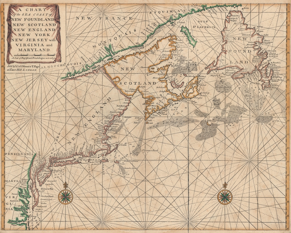
A Chart of the Sea Coast of New Foundland, New Scotland, New England, New York, New Jersey, with Virginia and Maryland.
1750 (undated) 18 x 22.5 in (45.72 x 57.15 cm) 1 : 5618700
1750 (undated) 18 x 22.5 in (45.72 x 57.15 cm) 1 : 5618700
Description
A very attractive c. 1750 example of John Thornton and Mount and Page's important nautical chart or maritime map of the eastern coast of North America from Cape Henry to the Mouth of the St. Lawrence.
A Closer Look
The map includes the coasts of Virginia, Maryland, New Jersey, New York, Delaware, Massachusetts, Maine, Nova Scotia, and Newfoundland as well as illustrating the Chesapeake Bay and Delaware Bay in full. Shading indicates the various offshore shoals, including the Nantucket Shoals, St. Georges Bank, the Shoals of Acadia, the Sable Island Shoals, and others. Depth soundings appear throughout, particularly on shoals and important harbors such as the Chesapeake Bay, New York, and Martha's Vineyard. Various rivers, cities, and towns are noted along the coast including Philadelphia, New York, Boston, among others.Publication History
This important and popular chart was issued in various editions of The English Pilot and the Atlas Maritimus for almost 100 years. There are only two known states, of which this is the second. The first state was drawn by John Thornton in 1698 and the second revised by Mount and Page 1749, both were published by Mount and Page. Cartographically, the two are similar being based upon the same Thornton data; however, in the second state the author added decorative draping to the cartouche and changed the title from 'New Found Land' to 'New Foundland.' The Irish map publisher George Grierson also published a pirated version of this map in 1749 and 1767.Cartographer
Mount and Page (fl. 1701 - 1760) was a London based firm of religious and maritime publishers that flourished in the 18th century. With the publication of the 1732 English Pilot, the Mount and Page name became well-known worldwide as an imprint of nautical charts. The firm was founded at Tower Hill, London, in 1701 by Richard Mount (1654 - 1722) and his apprentice Thomas Page (1780 - March 15, 1733). Mount had previously been in partnership with his father-in-law William Fisher (1631 - 1691) and inherited the business on the latter's death. Page completed his apprenticeship in 1716. Now fully partnered, Mount and Page subsequently acquired the map plates several defunct British nautical chart publishers, including Greenville Collins, Jeremiah Seller, Charles Price, and John and Samuel Thornton - thus nearly monopolizing the British nautical chart business. The firm consequently received several lucrative government contracts and thereby flourished throughout the 18th century, making the fortunes of both families. Successive generations of Mounts and Pages worked in the business, and the families intermarried. Its staple titles were The English Pilot and Navigatio Britannica by John Barrow. By the 1760s, Richard Mount's grandson John Mount (1725 - 1786) was able to retire to Berkshire where he built the stately mansion, Wasing Place. John's son William (1753 - 1815) was the last to work in the map business, and later generations went into politics. More by this mapmaker...
Condition
Very good. Slight toning. Minor wear on original centerfold. Close left and right margins.
References
Verner, Coolie, Carto-bibliographical study of the English pilot, the fourth book, no. 20, p. 47, Note 4. New York Public Library, Map Div. 97-6373 [LHS 653]. McCorkle, B. B, New England in Early Printed Maps 1513 - 1800, 698.6. Sellers, John R. and Van Ee, Patricia, Maps and Charts of North America, no. 199.