
Mount and Page

Mount and Page (fl. 1701 - 1760) was a London based firm of religious and maritime publishers that flourished in the 18th century. With the publication of the 1732 English Pilot, the Mount and Page name became well-known worldwide as an imprint of nautical charts. The firm was founded at Tower Hill, London, in 1701 by Richard Mount (1654 - 1722) and his apprentice Thomas Page (1780 - March 15, 1733). Mount had previously been in partnership with his father-in-law William Fisher (1631 - 1691) and inherited the business on the latter's death. Page completed his apprenticeship in 1716. Now fully partnered, Mount and Page subsequently acquired the map plates several defunct British nautical chart publishers, including Greenville Collins, Jeremiah Seller, Charles Price, and John and Samuel Thornton - thus nearly monopolizing the British nautical chart business. The firm consequently received several lucrative government contracts and thereby flourished throughout the 18th century, making the fortunes of both families. Successive generations of Mounts and Pages worked in the business, and the families intermarried. Its staple titles were The English Pilot and Navigatio Britannica by John Barrow. By the 1760s, Richard Mount's grandson John Mount (1725 - 1786) was able to retire to Berkshire where he built the stately mansion, Wasing Place. John's son William (1753 - 1815) was the last to work in the map business, and later generations went into politics.
Important State of the dominant chart of Colonial Virginia.
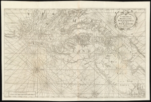
Virginia, Maryland, Pennsilvania, East and West New Jarsey...
$4,000.00
Acquire
- Digital Map Information
- Suitable for large format printing
- DPI: 600
- File Size: 89.65 MB
- File Type: ZIP / TIFF
- ICC color profile embedded
- Delivered instantly via download link
This is a superb example of William Mount and Thomas Page's large nautical map of the Chesapeake Bay and Delaware Bay in the 1742 first state. It represents the dominant English depiction of the water approaches to Virginia, Maryland, Delaware, and New Jersey for most of the Colonial Period. (more details)
Dominant early 18th century chart of northeastern America.
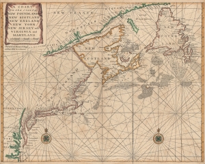
A Chart of the Sea Coast of New Foundland, New Scotland, New England, New York, New Jersey, with Virginia and Maryland.
$1,500.00
Acquire
- Digital Map Information
- Suitable for large format printing
- DPI: 600
- File Size: 25.77 MB
- File Type: ZIP / TIFF
- ICC color profile embedded
- Delivered instantly via download link
A very attractive c. 1750 example of John Thornton and Mount and Page's important nautical chart or maritime map of the eastern coast of North America from Cape Henry to the Mouth of the St. Lawrence. (more details)
South Carolina at the end of the French and Indian War.
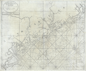
A Large Draft of South Carolina from Cape Roman to Port Royall.
$4,500.00
Acquire
- Digital Map Information
- Suitable for large format printing
- Full resolution TIFF file
- ICC color profile embedded
- Delivered instantly via download link
A rare 1763 Mount and Page nautical chart or maritime map of the coast of South Carolina issued at the end of the French and Indian War (1754 - 1763). Centered on Charleston (Charles Town), the map covers from the Santee River and Cape Romain (Cape Roman) to Hilton Head and Port Royal - a prosperous area covering the main ports of the cotton and tobacco trade. The cartographer notes various Indian and European Settlements, including the Scotts Settlements, Sr. Peter Colleons Signory, the Edestow Settlements (Edisto Settlements), the site of a Sewee Indian village, and more. There are soundings along much of the coastline, but particularly concentrated around Charleston and Port Royal (more details)
Most accurate map of Jamaica available to the English navigator.
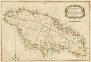
A New and Correct Chart of the Island of Jamaica wih its Bays, Harbors, Rocks, Soundings etc. Sold by J. Mount and T. Page on Tower Hill.
$750.00
Acquire
- Digital Map Information
- Suitable for large format printing
- DPI: 600
- File Size: 26.47 MB
- File Type: ZIP / TIFF
- ICC color profile embedded
- Delivered instantly via download link
This detailed, large 1773 Mount and Page map of Jamaica was, at the time of its publication, one of the most accurate maps of the island available to the English navigator - The English Pilot being the first entirely English sea atlas to focus on American waters. (more details)
Texas, by a Californian schoolboy.
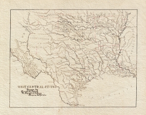
West Central States. Drawn by Ernest W. Dubois, St. Augustine College, Benicia, California.
$550.00
Acquire
- Digital Map Information
- Suitable for large format printing
- File Size: 4.79 MB
- File Type: ZIP / TIFF
- ICC color profile embedded
- Delivered instantly via download link
An attractive manuscript schoolboy / schoolgirl map of Texas by Ernest W. DuBois. Entitled the 'West Central States,' this map in fact focuses primarily on Texas with the adjacent Indian Territory (Oklahoma), Louisiana, and Arkansas also included. The map is finely drawn throughout with great attention to rivers and town placement. No counties are identified. (more details)