Digital Image: 1868 Dutton Pocket Map of Massachusetts
NewMassachusetts-dutton-1868_d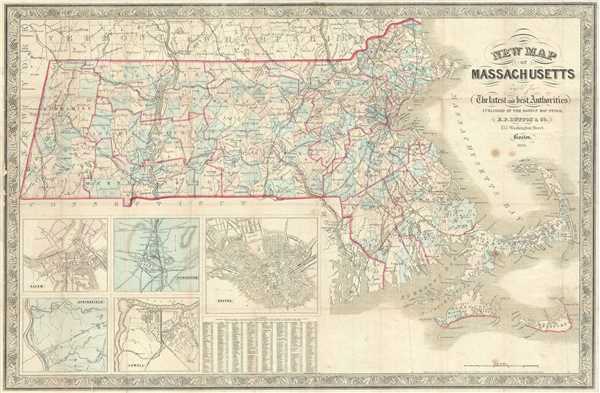

Title
New Map of Massachusetts.
1868 (dated) 20.5 x 30.5 in (52.07 x 77.47 cm) 1 : 427700
1868 (dated) 20.5 x 30.5 in (52.07 x 77.47 cm) 1 : 427700
Description
FOR THE ORIGINAL ANTIQUE MAP, WITH HISTORICAL ANALYSIS, CLICK HERE.
Digital Map Information
Geographicus maintains an archive of high-resolution rare map scans. We scan our maps at 300 DPI or higher, with newer images being 600 DPI, (either TIFF or JPEG, depending on when the scan was done) which is most cases in suitable for enlargement and printing.
Delivery
Once you purchase our digital scan service, you will receive a download link via email - usually within seconds. Digital orders are delivered as ZIP files, an industry standard file compression protocol that any computer should be able to unpack. Some of our files are very large, and can take some time to download. Most files are saved into your computer's 'Downloads' folder. All delivery is electronic. No physical product is shipped.
Credit and Scope of Use
You can use your digial image any way you want! Our digital images are unrestricted by copyright and can be used, modified, and published freely. The textual description that accompanies the original antique map is not included in the sale of digital images and remains protected by copyright. That said, we put significant care and effort into scanning and editing these maps, and we’d appreciate a credit when possible. Should you wish to credit us, please use the following credit line:
Courtesy of Geographicus Rare Antique Maps (https://www.geographicus.com).
How Large Can I Print?
In general, at 300 DPI, you should at least be able to double the size of the actual image, more so with our 600 DPI images. So, if the original was 10 x 12 inches, you can print at 20 x 24 inches, without quality loss. If your display requirements can accommodate some loss in image quality, you can make it even larger. That being said, no quality of scan will allow you to blow up at 10 x 12 inch map to wall size without significant quality loss. For more information, it is best consult a printer or reprographics specialist.
Refunds
If the high resolution image you ordered is unavailable, we will fully refund your purchase. Otherwise, digital images scans are a service, not a tangible product, and cannot be returned or refunded once the download link is used.
Cartographer
Edward Payson 'E.P.' Dutton (January 4, 1831 - September 6, 1923) was an American book publisher. Born in Keene, New Hampshire, Dutton was the son of George Damon Dutton and Mary Dutton. In 1852, Dutton founded the E.P. Dutton bookselling company in Boston, Massachusetts. Dutton initially sold fiction and nonfiction books, but soon included children's literature in his inventory. In 1864, Dutton opened a store in New York City and permanently moved his operation there in 1869. In that same year Dutton began publishing books. In 1888, Dutton began working with Ernest Nistor, and in 1906 Dutton struck a lucrative deal with the English publishing firm J.M. Dent to be the American distributor of the Everyman's Library. Even after his death, Dutton's company continued to grow prosper and is now an imprint of the Penguin Group. Dutton married Julia Maria Sleeper. More by this mapmaker...
References
Rumsey 5227.000 (1869 edition). OCLC: 55645729. Boston Public Library, G3760 1836 .N4.