This item has been sold, but you can get on the Waitlist to be notified if another example becomes available, or purchase a digital scan.
1668 Doncker Map of the Atlantic, with early Dutch New York (New Amsterdam)
NewNederlandBrazil-doncker-1668$500.00

Title
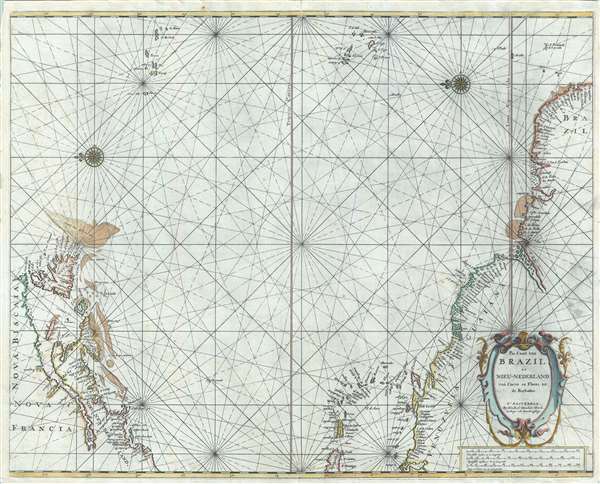
Pas Caart van Brazil en Nieu-Nederland van corvo en Flores tot de Barbados.
1668 undated 17 x 21.5 in (43.18 x 54.61 cm) 1 : 14000000
1668 undated 17 x 21.5 in (43.18 x 54.61 cm) 1 : 14000000
Description
A rare 1668 nautical chart or maritime map depicting the northern Atlantic Ocean by Hendrick Doncker. The map captures, on one sheet, the two centers of Dutch influence in the Americas - New Amsterdam (New York) and Dutch Brazil.
Although the usual projection, blank at the center with the eastern parts of North America and Brazil defined by the distant Azores and Cape Verde Islands, might seem bizarre, it was well-considered. Jacobsz drew this based upon Blaeu's monumental 1630 West Indische Paskaert. His intention was to present the most important information to his readers on Blaeu's great map in an easily accessible form. This map focuses on those areas most interesting to the 17th century Dutchman, the Dutch VOC colonies in Nieu-Nederland (New Amsterdam / New York City) and in Brazil (where the VOC was faring poorly in a war with Portugal over domination of the valuable sugar trade). The Canary Islands and the Azores have undoubtedly been included as the map's easternmost point because they are the traditional gateways to the Atlantic. The Spanish-controlled territories to the west, in Mexico, the Caribbean, and the Gulf of Mexico, were of little comparative interest.
A Closer Look
Oriented toward the east, coverage embraces from Newfoundland south to modern-day Paraiba, Brazil; east as far as the Azores and Cape Verde Islands; and west as far as Hispaniola. Doncker derived this map from a similar map issued in 1650 by Theunis Jacobsz.Although the usual projection, blank at the center with the eastern parts of North America and Brazil defined by the distant Azores and Cape Verde Islands, might seem bizarre, it was well-considered. Jacobsz drew this based upon Blaeu's monumental 1630 West Indische Paskaert. His intention was to present the most important information to his readers on Blaeu's great map in an easily accessible form. This map focuses on those areas most interesting to the 17th century Dutchman, the Dutch VOC colonies in Nieu-Nederland (New Amsterdam / New York City) and in Brazil (where the VOC was faring poorly in a war with Portugal over domination of the valuable sugar trade). The Canary Islands and the Azores have undoubtedly been included as the map's easternmost point because they are the traditional gateways to the Atlantic. The Spanish-controlled territories to the west, in Mexico, the Caribbean, and the Gulf of Mexico, were of little comparative interest.
A Familiar Map, Updated
While Doncker draws on Jacobsz for this map's basic form, it is by no means a slavish copy. The map has been updated with more advanced toponymy (for example, 'Gebroken Lant' is introduced for Long Island) and an updated presentation of the inland waterways, notably the St. Lawrence and Amazon Rivers. Shading has also been added to illustrate offshore shoals and reefs. In New York and New England, New Amsterdam is named, and the Hudson River appears as the Maritius River. Sandy Hook, Cape May (Delaware Bay Entrance), and Cape Cod are easily recognizable.Publication History
According to Burden, Doncker first issued this map in 1659 with a different cartouche. A second edition was issued in 1672, and a third in 1676. Following Burden's cartobibliography, this would suggest that the present map is the second 1672 state. However, we happen to know that this particular example came from an unrecorded 1668 French edition of Doncker's Monde Aquatique not traced in Koeman. While it is not impossible that this map may have been tipped into the atlas later, we find it more likely that either Burden's dating of this state of the map requires revision. The extreme rarity of all editions of this map in both institutional and private collections makes it very difficult to compare states side by side to determine if this is just an early appearance of Burden state 2 or an unrecorded state.Cartographer
Hendrick Doncker (1626 - 1699) (a.k.a. Henri Donker) was a Dutch bookseller and publisher of sea charts and nautical atlases active in Amsterdam during the middle part of the 17th century. He maintained a presence on Nieuwe Brugsteeg, Amsterdam. He married Elizabeth Abrahamsd Rensing in 1647. Doncker was somewhat unique to this period in that he did not copy the work of earlier cartographers, instead producing his own map. Moreover, Doncker's charts were widely admired for their constant revision and overall accuracy. In addition to producing his own charts, he also collaborated with Pieter Goos and Anthonie Jacobsz to producing the pilot guide De Zeespiegel. Following his 1699 death, Doncker's remaining stock and valuable map plates were acquired by Johannes van Keulen. He was survived by a daughter, Anna Doncker. More by this mapmaker...
Source
Doncker, Hendrick, L'Atlas de Mer ou Monde Aquatique, (Amsterdam) 1668.
Condition
Very good. Minor verso reinforcement near centerfold at margins.
References
Burden, Phillip D., The Mapping of North America: A List of Printed Maps, 1511-1670, #338, state 2.