1826 Cruchley Pocket City Plan or Map of London, England
NewPlanLondon-cruchley-1826$900.00

Title
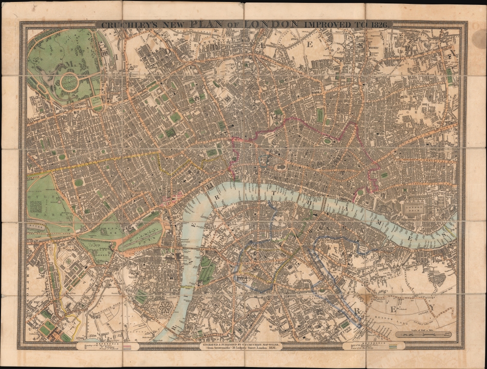
Cruchley's New Plan of London. Improved to 1826.
1826 (dated) 18.5 x 24.75 in (46.99 x 62.865 cm) 1 : 12520
1826 (dated) 18.5 x 24.75 in (46.99 x 62.865 cm) 1 : 12520
Description
This is an 1827 George F. Cruchley pocket city plan or map of London, England. Depicting from Hyde Park to the London Dock and from Camden Town to Kennington and Walworth, Cruchley uses color to highlight the boundaries of the City of London, Westminster, and Southwark. Colored boundaries also mark the Rules of the King's Bench Prison and the Rules of the Fleet Prison, along with the 'Extent of the Clink Liberty'. These three areas were boundaries within which convicts could serve out their sentences outside the prison walls, usually for a very high price. Roads are illustrated and labeled throughout the city, along with squares, gardens, and other buildings. St. Paul's Cathedral, the Tower of London, Westminster Abbey, Buckingham Palace, and the Houses of Parliament are all labeled.
Publication History and Census
This map was created and published by George F. Cruchley in 1826. We note a single cataloged example, which is part of the collection at Yale University.Cartographer
George Frederick Cruchley (April 23, 1797 - June 16, 1880) was a London based book and map seller active in the middle part of the 19th century. Cruchley began his cartographic career as an apprentice at the venerable Aaroon Arrowsmith firm. Many of Cruchley's earliest maps bear the words 'From Arrowsmith's' on the imprint. In 1844, Cruchley acquired the massive stock of the important early 19th century firm of John Cary. Cruchley published his own maps as well as reissues of Cary's stock well into the 1870s. He is best known for his detailed plans of London, which in recent years have become increasingly scarce and desirable. Cruchley was based in London on 38 Ludgate Street until 1834 when he moved his offices to 81 Fleet Street. Shortly before his death in 1880 Cruchely auctioned (Hodgson's Auctions, Jan 16, 1877) his entire stock. Many of his map plates were thusly acquired by 'Gall and Inglis' who continued the Cruchley tradition well into the early 20th century. Cruchley's son, also George Frederick (1837 - 1882), continued to work as a book and map seller until his death. More by this mapmaker...
Condition
Very good. Dissected and mounted on linen in twenty (20) panels. Light soiling.
References
Howgego, James L., Printed Maps of London circa 1553-1850#304 A1. OCLC 793030839.