
This item below is out of stock, but another example (left) is available. To view the available item, click "Details."
Details
1775 Montresor Map of New York and Vermont
$16,000.00
1775 Montresor Map of New York and Vermont
NewYork-montresor-1775$7,250.00


Title
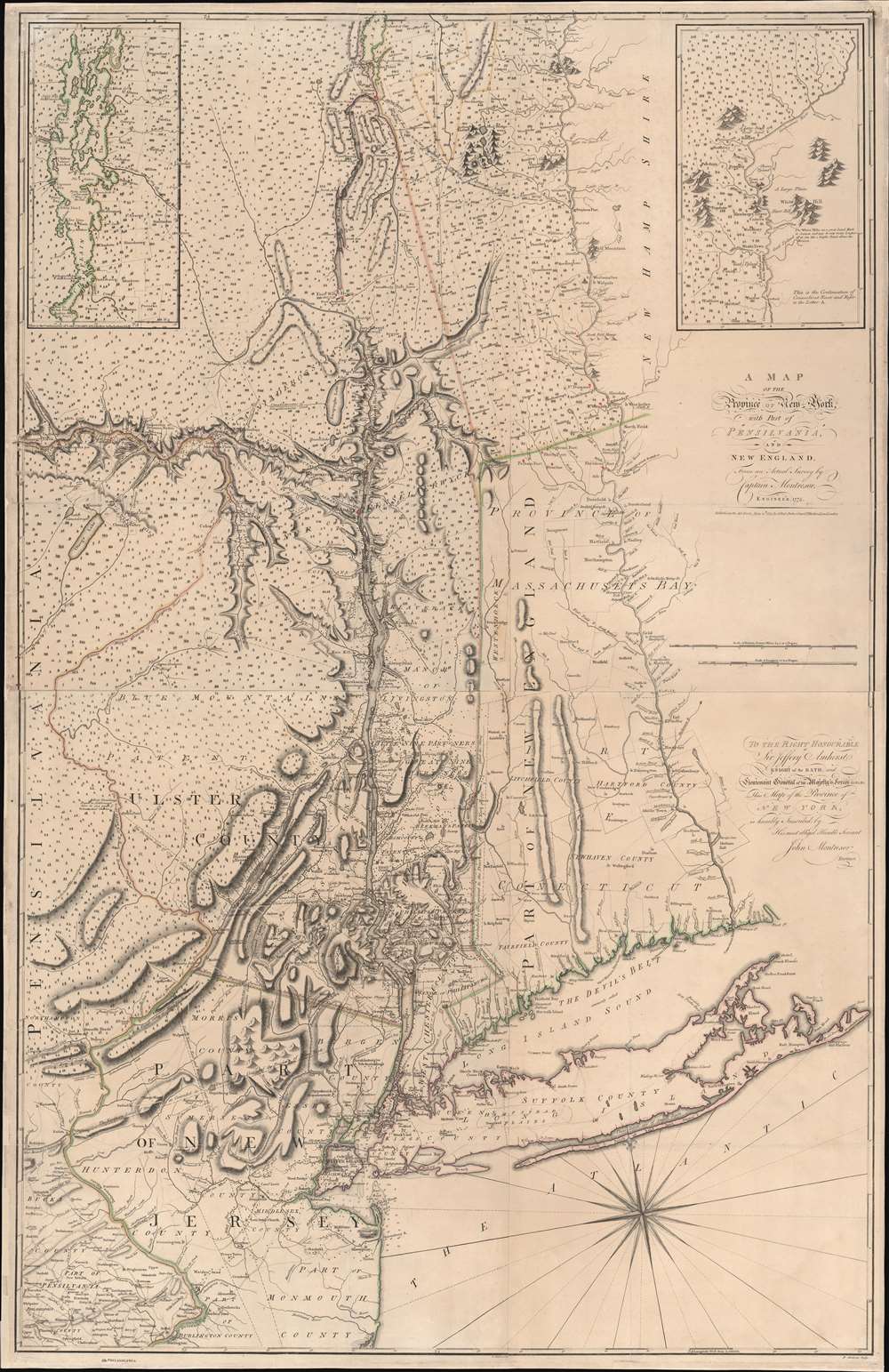
A Map of the Province of New-York, with Part of Pensilvania, and New England.
1775 (dated) 53 x 37.25 in (134.62 x 94.615 cm) 1 : 320000
1775 (dated) 53 x 37.25 in (134.62 x 94.615 cm) 1 : 320000
Description
This is John Montresor's striking 1775 map of New York and the surrounding regions - considered the best and most authoritative map of the region at the beginning of the American Revolutionary War (1775 - 1783).
A Closer Look
The map focuses on the vital Hudson Valley Corridor between New York and Lake Champlain - a significant theater in both the French and Indian War and the impending American Revolution. Coverage extends on both sides of the Hudson to incorporate most of eastern New York, Northern New Jersey, of all modern-day Vermont, Long Island, and the western portions of Connecticut and Massachusetts. Montresor intended the map for military use with an emphasis on mobility and troop movements, thus clearly illustrating roads, river and canal systems, and topography. The map also delineates the boundaries of land patents in the Hudson Valley and towns in western New England as well as the locations of forts, farms, and various interpretations of the disputed New York-New Jersey boundary (which Montresor helped survey). Insets in the upper corners detail Lake Champlain and the Connecticut River Valley. The future Vermont is segregated out, but included as part of New York.Sources
Montresor began compiling his own and other surveys during his service in the French and Indian War (1754 - 1763). Much of his own work is evident on the map, including his 1765 - 1771 surveys of the disputed New York-New Jersey border. Other sources include the work of Samuel Holland and William Brasier. Southern New England and Long Island are copied closely from Jefferys' 1755 Map of the Most Inhabited Part of New England. Although much is evident in comparative studies of the relevant source maps, Montresor, having a jealous and proprietary character, offers no credit. It has been speculated that the map was largely complete by 1765, but remained unpublished until 1775, when the outbreak of the American Revolutionary War made it relevant.Publication History and Census
Montresor likely completed the underlying compiling and drafting of this map by 1771, but it was not engraved or published until 1775. The map was engraved in London by Peter Andrews (Pierre André) and published by Andrew Dury. The first and second state (this example), both issued in 1775, are distinguished only by the naming of Fort Ticonderoga. A third state was issued in 1775, with significant updates and improvements - mostly to the roads. The fourth state, with annotations relating to the Revolution, was issued in 1777. We also note a fully re-engraved French edition by Georges Louis Le Rouge, which appeared in 1777.CartographerS
John Montresor (April 22, 1736 – June 1799) was a British military engineer and cartographer. He was born in Gibraltar to military engineer James Gabriel Montresor. Although educated in England, he learned the rudiments of his future trade from his father, working as his assistant. The two came to America in 1754. The next year the young Montresor served as ensign on the disastrous Braddock expedition, in which the British failed to capture the French Fort Duquesne (Pittsburgh) during the French and Indian War (1754 - 1763). Montresor was wounded in the debacle, but nonetheless recede a promotion to Lieutenant. Upon recovering, Montresor went on to serve in northern New York, and accompanied British forces to Halifax. In 1758, commissioned to the Corps of Engineers, he was present at the sieges of Louisbourg and of Quebec (where he drew one of the last known portraits of the doomed General Wolfe.) Following the defeat of the French, the language-handy Montresor was sent as far afield as Cape Breton to elicit oaths of allegiance from Francophone Canadians. During this period, he surveyed and prepared maps of Acadia, the Saint Lawrence River, and of the Kennebec River. He designed and built fortifications in the vicinity of Niagara Falls. As resistance to the Stamp Act built and the Revolution loomed, he surveyed the boundaries between New York and New Jersey. In 1765 in a New York embroiled with Stamp Act riots, Montresor was tasked to draft a plan of the city in order to assist in quelling a full insurrection should it occur. The climate being hostile, Montresor carried out his surveys covertly. The onset of the War found him in Boston; he marched in relief of the British troops who fought at Concord, and took part in the Battles of Long Island and in the 1777 campaigns in New Jersey and Philadelphia, where he launched the attack that destroyed his own Mud Island defenses. Despite his twenty three years of service, he watched as others were repeatedly promoted ahead of him as chief engineer, and he was never promoted beyond Captain. Embittered, he resigned from the military in 1779. More by this mapmaker...
Andrew Dury (fl. 1742 - 1778) was a London based engraver, map publisher, and map seller working in the mid to late 18th century. Little is known of Dury's life. Hw was likely born in Ireland, but spent considerable time in Paris until about 1754. He first appeares in Dublin in 1754, possibly in the company of John Rocque (1704 - 1762), which whom he is closely associated. At that time he advertised himself as an engraver 'Late of Paris'. His imprint often appears on the work of a number of prominent London publishers from Sayer and Bennet to Laurie and Whittle and Gentlemans' Magazine. Learn More...
Peter Andrews / Pierre André (September 27, 1736 - 1782) was an English-French engraver active in London in the mid to late 18th century. He was born in London and Baptized at the French Church in Threadneedle. He may have been of Huguenot extraction and is closely associated with fellow Huguenot, John Rocque (c. 1704 - 1762). He is also regularly associated with Andrew Dury (fl. 1742 - 1778). Learn More...
Condition
Very good. Separate issue. Relaid on fresh linen.
References
Stevens, H. and Tree, R., 'Comparative Cartography', in Tooley, R. V., The Mapping of America, #42. Schwartz, S. and Ehrenberg, R., The Mapping of America, pl. 114. Boston Public Library, Leventhal, LCCN 74692645 (1st state). Guthorn, British Maps of the American Revolution, pp. 34-37. Taliaferro, Henry and Pritchard. Margaret Beck, Degrees of Latitude: Mapping Colonial America, 24.