This item has been sold, but you can get on the Waitlist to be notified if another example becomes available, or purchase a digital scan.
1951 U.S.G.S. Aviation Map of the World centered on New York City
NewYork-uscgs-1951$250.00

Title
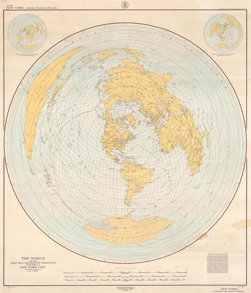
The World on the Azimuthal Equidistant Projection Centered at New York City.
1951 (dated) 42.5 x 35 in (107.95 x 88.9 cm) 1 : 47423730
1951 (dated) 42.5 x 35 in (107.95 x 88.9 cm) 1 : 47423730
Description
This is a 1951 U.S. Coast and Geodetic Survey map of the world with New York City at its literal center. The map employs an azimuthal equidistant projection to accurately depict direct aviation 'great circle' routes from New York City to anywhere else in the world. Concentric red circles mark distances of 1,000 statute miles from New York City. The map provides an example of how this works, 'the path of the great circle between New York and Cape Town may be located and the distance scaled as 7,802 statute miles is correct'. Smaller maps situated in the upper left and right present the world using the same projection with different cities at the center: London and Tokyo.
Publication History and Census
This map was created by the U.S. Coast and Geodetic Survey and published by the U.S. Department of Commerce in 1951. We note thirteen cataloged examples in OCLC including in the collections at the Library of Congress, the University of Michigan, and the University of Chicago.Cartographer
The Office of the Coast Survey (1807 - present) founded in 1807 by President Thomas Jefferson and Secretary of Commerce Albert Gallatin, is the oldest scientific organization in the U.S. Federal Government. Jefferson created the "Survey of the Coast," as it was then called, in response to a need for accurate navigational charts of the new nation's coasts and harbors. The spirit of the Coast Survey was defined by its first two superintendents. The first superintendent of the Coast Survey was Swiss immigrant and West Point mathematics professor Ferdinand Hassler. Under the direction of Hassler, from 1816 to 1843, the ideological and scientific foundations for the Coast Survey were established. These included using the most advanced techniques and most sophisticated equipment as well as an unstinting attention to detail. Hassler devised a labor intensive triangulation system whereby the entire coast was divided into a series of enormous triangles. These were in turn subdivided into smaller triangulation units that were then individually surveyed. Employing this exacting technique on such a massive scale had never before been attempted. Consequently, Hassler and the Coast Survey under him developed a reputation for uncompromising dedication to the principles of accuracy and excellence. Unfortunately, despite being a masterful surveyor, Hassler was abrasive and politically unpopular, twice losing congressional funding for the Coast Survey. Nonetheless, Hassler led the Coast Survey until his death in 1843, at which time Alexander Dallas Bache, a great-grandson of Benjamin Franklin, took the helm. Bache was fully dedicated to the principles established by Hassler, but proved more politically astute and successfully lobbied Congress to liberally fund the endeavor. Under the leadership of A. D. Bache, the Coast Survey completed its most important work. Moreover, during his long tenure with the Coast Survey, from 1843 to 1865, Bache was a steadfast advocate of American science and navigation and in fact founded the American Academy of Sciences. Bache was succeeded by Benjamin Pierce who ran the Survey from 1867 to 1874. Pierce was in turn succeeded by Carlile Pollock Patterson who was Superintendent from 1874 to 1881. In 1878, under Patterson's superintendence, the U.S. Coast Survey was reorganized as the U.S. Coast and Geodetic Survey (C & GS) to accommodate topographic as well as nautical surveys. Today the Coast Survey is part of the National Oceanic and Atmospheric Administration or NOAA as the National Geodetic Survey. More by this mapmaker...
Condition
Very good. Exhibits light soiling. Closed margin tears professionally repaired on verso. Closed tear extending two-and-one-quarter (2.25) inches into printed area in top left corner professionally repaired on verso.
References
OCLC 162194204.