1855 Fanning Map of New York City
NewYorkCity-fanning-1855$1,500.00

Title
Fanning's Map of New-York City.
1855 (dated) 28 x 15.5 in (71.12 x 39.37 cm) 1 : 22600
1855 (dated) 28 x 15.5 in (71.12 x 39.37 cm) 1 : 22600
Description
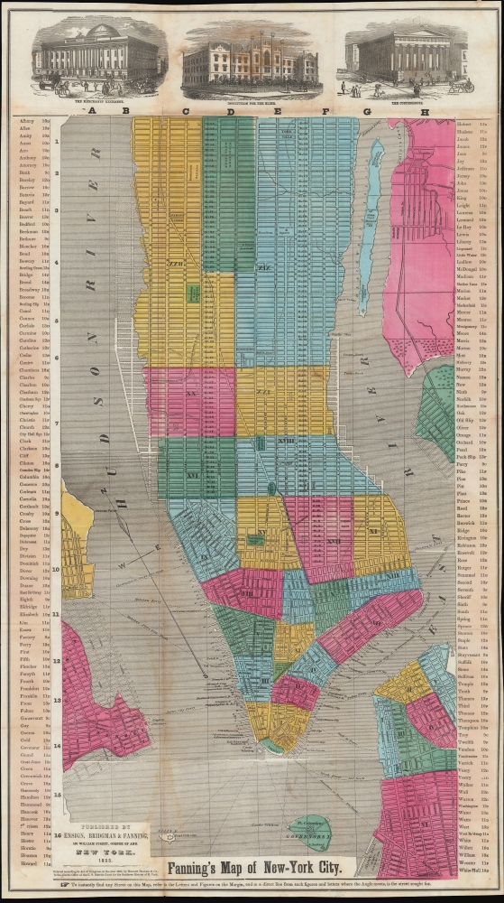
An example of Thomas Fanning's 1855 map of New York City. Among several interesting features, it is most notable for including presumed future development, including in the central part of Uptown Manhattan, some of which in the process of being designated for Central Park.
Fanning's presumptions about future development here were entirely sensible. By this map's publication, the groundwork for the city's future growth was already laid, including reservoirs, rail lines, and the city's characteristic standardized geometric street grid. In fact, the logic of the city's uniform development eventually cut through some of the extant recognizable sites, such as Hamilton Square. The park at Bloomingdale Square on the west side was also eliminated with the creation of Central Park in 1857. Manhattan Square was saved because it was handed over to the Central Park Commission, which was unsure of what to do with it until designating it for the American Museum of Natural History.
The 'Receiving Reservoir' seen here was retained in the plans for Central Park as the Croton Reservoir, also known as the Yorkville Reservoir (likely to avoid confusion with another Croton Reservoir further south). It was decommissioned and drained in the late 1920s, but an adjacent Upper Reservoir built along with Central Park remains as the picturesque Jacqueline Kennedy Onassis Reservoir.
A Closer Look
Coverage includes Manhattan south of 89th St., along with nearby portions of Queens, Brooklyn, Jersey City, and nearby islands. A grid surrounds the map with a corresponding index of street names appearing in the margins at left and right. City districts are shaded for easy differentiation and indicated with Roman numerals. On the water, ferry lines are traced with their distance in yards. At top, views of the Merchants' Exchange (55 Wall St.), the Institution for the Blind (at 34th St and Ninth Ave.), and the Customs House (Federal Hall, 26 Wall St.) appear. Presumed land reclamation and future development is ghosted in along the shoreline in Brooklyn, on both the eastern and western ends of Manhattan, and in Jersey City and Hoboken.(Just) Before Central Park
Similarly, much of the street grid uptown was projected, as the area was only sporadically populated. A snakelike curved line separates the most densely populated areas of the city, showing that it had already reached Yorkville on the east side. Still, much of the land north of 40th St. remained as rural villages and scattered homes. The central part of this portion of Manhattan, which became Central Park, was then inhabited by established communities of free people of color, specifically Seneca Village, which were later displaced. Although here the street grid overlays both Seneca Village and the future Central Park, its green shading indicates that Fanning was aware of the negotiations then in progress.Fanning's presumptions about future development here were entirely sensible. By this map's publication, the groundwork for the city's future growth was already laid, including reservoirs, rail lines, and the city's characteristic standardized geometric street grid. In fact, the logic of the city's uniform development eventually cut through some of the extant recognizable sites, such as Hamilton Square. The park at Bloomingdale Square on the west side was also eliminated with the creation of Central Park in 1857. Manhattan Square was saved because it was handed over to the Central Park Commission, which was unsure of what to do with it until designating it for the American Museum of Natural History.
The 'Receiving Reservoir' seen here was retained in the plans for Central Park as the Croton Reservoir, also known as the Yorkville Reservoir (likely to avoid confusion with another Croton Reservoir further south). It was decommissioned and drained in the late 1920s, but an adjacent Upper Reservoir built along with Central Park remains as the picturesque Jacqueline Kennedy Onassis Reservoir.
Publication History and Census
This map was published by Ensign, Bridgman, and Fanning in New York in 1855, with a copyright entered by Horace Thayer dated to 1853. This edition of the map is quite scarce, only being noted among the holdings of Stanford University. An edition dated to 1854 (OCLC 83866120) is also present in the collections of the Wisconsin Historical Society, the University of Chicago, the Fenimore Art Museum, Swarthmore College, Middlebury College, the New York State Library, and the New York Public Library. Additionally, the 1854 edition of Phelps' New York City guide (OCLC 1050759080 - digital and physical examples co-mingled) included Fanning's map of that year.CartographerS
Thomas Colt Fanning (August 2, 1805 - November 21, 1873) was a New York based map publisher active in the middle part of the 19th century. Fanning was born in Norwich, Connecticut. As a young man he apprenticed at a drugstore in Rochester, New York. When he reached his maturity, he relocated to Albion, New York, where he opened the town's first drugstore. He sold this business in 1849 to move to Brooklyn and enter the map publishing business. He initially partnered with Humphrey Phelps (1799 - 1875) and Thomas C. Fanning (1805 - 1873), joining the firm of 'Phelps and Fanning' as a junior partner. From 1854 to 1863 he partnered with Edward H. Ensign (1818 - 1871) and Erastus Clark Bridgman (1817 - 1870), publishing as 'Ensign, Bridgman and Fanning.' More by this mapmaker...
Edward Hooker Ensign (August 18, 1818 - July 10, 1871) was an American map and print publisher based in New York during the middle part of the 19th century. Edward was born in West Hartland, Connecticut. Little is known of Ensign's training but he may have inherited his business from his father, Timothy Ensign (1795 - 1859), who was a map publisher active in New York. Ensign seems to have had a flair for partnerships and variously published with Humphrey Phelps (1799 - 1875), Horace Thayer, Thomas C. Fanning (1805 - 1873) and Erastus C. Bridgman (1817 - 1870), among others. His various imprints include 'Phelps and Ensign' (1841-1844), 'T. and E. H. Ensign' (1844-1848), 'Ensign and Thayer' (1849), 'Ensign, Thayer, and Company' (1850-1851), 'Horace Thayer and Company' (1852), and 'Ensign, Bridgman and Fanning' (1854-1863). It appears that father and son worked together for some time as well, publishing as either 'T. and E. H. Ensign' or 'Ensigns'. At least some of these companies maintained offices in both Buffalo and New York City. Learn More...
Erastus Clark Bridgman (October 31, 1817 - August 25, 1870) was a New York City based map publisher active in the middle of the 19th century. Bridgman was born in Westhampton, Massachusetts. He was in South Carolina in 1849, where his first child was born, but moved to New York City by 1850. Bridgman was in partnership with Edward H. Ensign (1818 - 1871) and Horace Thayer from 1850 - 1852, publishing under the imprint of 'Ensign, Thayer, and Co.' Later, from 1854 - 1863, the partnership changed to Edward H. Ensign, Thomas C. Fanning (1805 - 1873), and Bridgman, publishing as 'Ensign, Bridgman and Fanning.' After his death, the Bridgman firm was taken over by his son Edward Clark Bridgman (1849 - 19??). Learn More...
Horace Thayer (June 29, 1811 - March 15, 1875) was a New York based publisher and lithographer active in New York City and Buffalo, New York, during the middle part of the 19th century. Thayer's publications focused on travel guides, wall, and pocket maps - many of which were based on the works of other American cartographers including J. H. Colton and S. A. Mitchell. In the 1840s, he partnered with the Hartford, Connecticut publisher Timothy Ensign (1795 - 1849) and later his son, Edward Hooker Ensign (1818 - 1871). According to map historian Walter Ristow, J. H. Colton's older son, George Washington Colton, partnered with Thayer in the late 1850s and early 1860s, possibly in order to learn Thayer's lithography techniques. Certainly a number of maps emerged bearing a 'Thayer and Colton' imprint. At various points Thayer also published with other prominent publishers and printmakers, publishing as Kelloggs and Thayer (1846 - 1847), Ensigns and Thayer (1848), Ensign and Thayer (1849 - 1850), and Ensign, Thayer, and Company (1850 - 1851), Phelps and Watson (1859), and Thayer and Colton (1859-186?). Thayer seems to have moved frequently and had offices at 50 Ann Street, 156 William Street, and at 18 Beekman Street, all in New York City. Learn More...
Condition
Good. Soiling and wear along fold lines and at top.
References
Rumsey 3614.003. OCLC 953569036.