1855 Magnus Map of New York City and Brooklyn - old color!
NewYorkCity-magnus-1855-3$1,800.00


Title
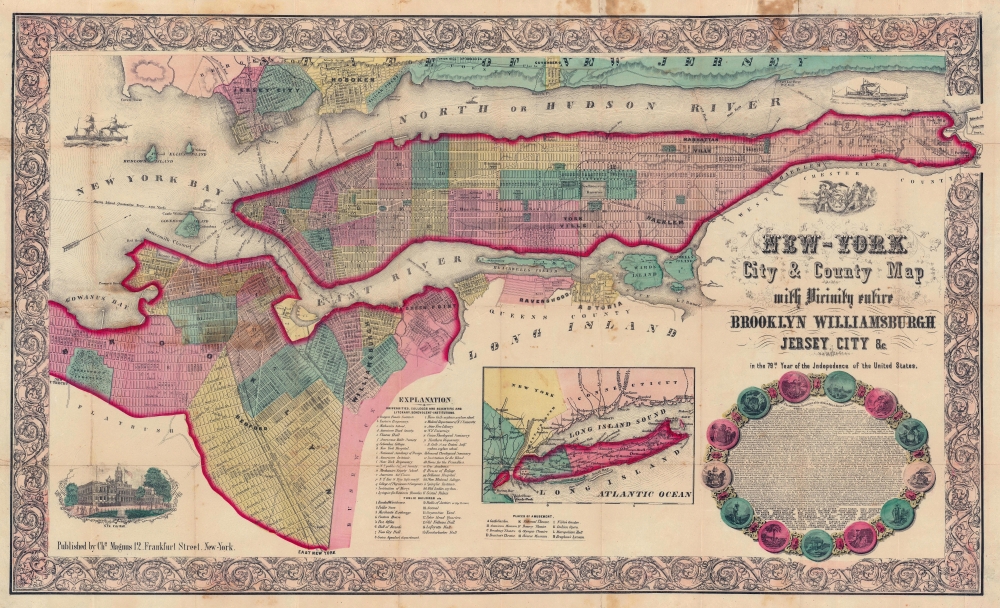
New-York City and County Map with Vicinity entire Brooklyn Williamsburgh Jersey City an c. in the 79th Year of Independence of the United States.
1855 (dated) 20 x 32 in (50.8 x 81.28 cm) 1 : 33000
1855 (dated) 20 x 32 in (50.8 x 81.28 cm) 1 : 33000
Description
The rare full-color edition of Charles Magnus's extraordinary 1855 broadside map of New York City, issued to commemorate the signing of the Declaration of Independence. This is one of the finest and most visually striking maps of New York City to appear in the 19th century. Moreover, the present example is only the 2nd full original color example of this map we have seen.
A Closer Look
The map depicts the entirety of Manhattan as well as most of Brooklyn, Bedford-Stuyvesant, Williamsburg, Greenpoint, Queens, Ravenswood, Astoria, Jersey City, and Hoboken. An inset map at the bottom center details Long Island. The whole is rendered in detail with special attention given to individual streets, blocks, parks, and important buildings. The map reveals the early growth of Hunters Point, or Long Island City in Queens. Important ferry crossings, canals, and railroads are also included. In Hoboken, Jersey City, and Long Island City, several planned landfills are indicated. Also in Hoboken, we see the Elysian Fields, a park along the Hudson River that hosted the world's first baseball game.Manhattan
In Manhattan, the map identifies various districts including Manhattanville, Yorkville, and Harlem. Central Park has yet to manifest and although the grid structure above 155th Street is ghosted in, it was not yet formally approved. Where Columbia University stands today, this map shows the location of the New York Lunatic Asylum. At the bottom center an alphanumerically keyed legend notes 'Universities, Colleges and Scientific and Literary, Benevolent-Institutions,' 'Public Buildings', and 'Places of Amusement.' In the lower left, there is an inset engraved depiction of New York's City Hall. Steamships are shown navigating the Hudson River in both the upper right and upper left quadrants.The Medallion
In the lower right an elaborate medallion features the full text of the Declaration of Independence as well as sigils representing each of the original 13 colonies. A bright blue pastedown, unique to this example, declares the purpose of this map, to commemorate the 79th Year of the Independence of these United States. The whole is surrounded by an attractive acanthus leaf motif border.Publication History and Census
This map was issued in lithograph in 1855 by the New York publisher Charles Magnus. Most examples are broadsheets, in black and white, intended for framing. At the same time, a few examples were issued as folding pocket maps, as here. These few were elaborated with a full hand-color treatment. While we have seen and handled other examples of the uncolored broadside, this is only the second example we have seen of this, full-color issue (the other one having passed through our hands about 5 years previous). It is unfortunately impossible to identify if examples held in some institutional collections are uncolored broadsides or colored pocket maps, as most are poorly cataloged and not digitized. It is nonetheless of extreme rarity on the market in any state, but particularly this full-color issue.Cartographer
Charles Magnus (1826 - 1900) was a New York City based stationer, illustrator, bookseller, and map and print publisher active in the middle to late 19th century. Magnus was born in Elberfeld, Germany, as Julian Carl Magnus. Fleeing the March Revolution in Germany, the Magnus family immigrated to New York City in 1848. In New York, Charles' brother Carl Emil had already established himself as the editor of a German weekly newspaper, Deutsche Schnellpost. It was through his brother that Magnus learnt the printing and publishing trade. The earliest work to bear the Magnus inscription dated to the 1850s and includes various pictorial broadsides and maps intended to commemorate important events - the most notable for map enthusiasts being his 1855 map of New York commemorating the '79th Year of Independence of the United States'. During the 1860s and years of the American Civil War, Magnus, through various political connections, became one of the few illustrators with unrestricted access to Union military camps. He is consequently particularly well known for his authentic view of Civil War cities, personages, and events. Following the war, Magnus began to develop a prosperous business creating and selling panoramic city views, song sheets, and patriotic envelopes. In all Charles Magnus, with over 1000 known works, was one of the most prolific American printers of broadsides and other lithographs. More by this mapmaker...
Condition
Very good. Comes with original binder. Map has been backed on archival tissue. There were a few older repairs on the verso, which causes some slight discoloration on the recto (apparent as brown spots). We have reversed and redone these repairs with archival materials. Original old color.
References
OCLC 23876813. Haskell, Daniel Carl, Manhattan Maps; a Co-operative List, 1004.