1901 (1915) U.S. Geological Survey Topographic Map of New York City
NewYorkCity-usgs-1915$950.00


Title
New York City and Vicinity.
1915 (dated) 46.5 x 34 in (118.11 x 86.36 cm) 1 : 62500
1915 (dated) 46.5 x 34 in (118.11 x 86.36 cm) 1 : 62500
Description
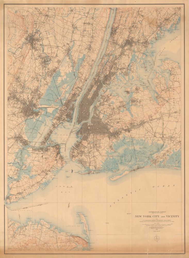
Produced soon after New York City's consolidation of the five boroughs, this large-format 1901 (reprinted 1915) topographic map of New York City and vicinity was produced by the U.S. Geological Survey. In addition to topographic information, it provides an excellent snapshot of the city at the turn of the 20th century.
Some individual buildings are drawn and easily recognizable, such as the American Museum of Natural History and New York City Hall. As the map was originally produced in 1901, it includes the Brooklyn Bridge but not the Williamsburg, Manhattan, or Queensboro Bridges, built in the intervening years. As the population of the city was growing at a remarkable pace in the early 20th century, Queens, Brooklyn, and the Bronx also saw significant new development between 1901 and 1915.
A Closer Look
Coverage includes portions of Westchester County, New Jersey, Long Island, and all five boroughs of New York City. Topography is displayed throughout and coastal wetlands, especially in Jamaica Bay, New Jersey, and Staten Island, are indicated with blue ink. The urban grid of New York and other cities are illustrated, along with roads, railways, electric railways, piers, and administrative boundaries.Some individual buildings are drawn and easily recognizable, such as the American Museum of Natural History and New York City Hall. As the map was originally produced in 1901, it includes the Brooklyn Bridge but not the Williamsburg, Manhattan, or Queensboro Bridges, built in the intervening years. As the population of the city was growing at a remarkable pace in the early 20th century, Queens, Brooklyn, and the Bronx also saw significant new development between 1901 and 1915.
Publication History and Census
This map was first published in 1901, soon after the city's consolidation in 1898, combining and updating quadrangle maps of the U.S. Geological Survey undertaken in the late 1880s. It was then reprinted by the Geological Survey in 1915 without significant changes. Aside from its size, this example is notable for being laid on linen.Cartographer
The United States Geological Survey (1878 - Present), aka the U.S.G.S., is a scientific agency of the United States government, which was founded in 1879. USGS scientists study the landscape of the United States, its natural resources, and the natural hazards that threaten it. The organization has four major science disciplines: biology, geography, geology, and hydrology. It is a bureau of the United States Department of the Interior and is the department's only scientific agency. More by this mapmaker...
Condition
Laid on original old linen. Overall toning. Some additional toning along bottom 2 inches. Repaired tear from bottom margin extending as far as scales.
References
OCLC 15288028.