This item has been sold, but you can get on the Waitlist to be notified if another example becomes available, or purchase a digital scan.
1867 Colton Map of Manhattan, New York City
NewYorkCityElevated-colton-1867$1,500.00


Title
Colton's City and County Map of New-York.
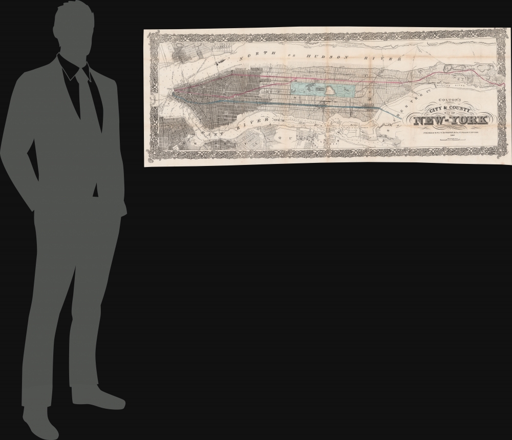
1867 (dated) 18 x 47 in (45.72 x 119.38 cm) 1 : 19500
1867 (dated) 18 x 47 in (45.72 x 119.38 cm) 1 : 19500
Description
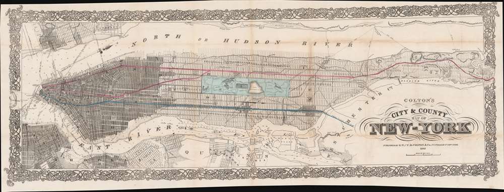
This is Colton's impressive 1867 map of Manhattan, representing the birth of public rapid transit in New York. The map is oriented loosely to the east, with coverage embracing all of Manhattan, as well as adjacent parts of Brooklyn, Queens, Hoboken, and Jersey City. Central Park - a wonder of civic design being completed as this map went to press - features prominently at the center. Significantly, the map reveals proposed elevated railroads highlighted in blue and red running from the Battery to the Harlem River - thus making this the first map to show the planning stages of public transit in New York, the precursor to the modern-day Subway.
Recognizing the problem, the Common Council financed a series of revolutionary urban improvements that transformed New York. These include the 1864 Egbert Viele Waterways Map, the construction of the Croton Aqueduct, and the 1858 - 1868 commissioning of Central Park. Another such innovation was the recognition of a need for a rapid public transportation system in the spirit of the London Underground, the vision being that the working-class populace could live in cheaper properties in upper Manhattan and Westchester while commuting quickly and easily to the downtown business district.
Several plans for a rapid transit system were put forward, including an underground system similar to London, a mid-block overland train, and an elevated system. The development of an underground system was dismissed as too expensive and impractical for New York; the mid-block system was derailed as it would have involved leveling numerous significant properties, but the Common Council approved plans for an elevated railway in 1866.
The approval first demanded that a 'test route' be constructed from Battery Place extending northward for one-half mile along Greenwich. This, completed about six months later, was New York's first public rapid transit system. Although plagued by mismanagement and construction issues, the experiment was declared a success, and construction moved forward on the planned lines, as noted on the map.
The East Side and New Rochelle Patent Railway Company received permission to construct an elevated railroad from Battery Park along Pearl Street to Bowery, and thence northward from Astor Place along 3rd Avenue to the Harlem River Bridge, and thence into Westchester. This is the blue line presented here and roughly corresponds to the modern-day 4/5/6 Subway lines.
In 1876, these companies were consolidated into the New York Elevated Railroad. It took until about 1880 for the lines to reach their terminus at the Harlem River, but both did. In 1878 alone, the NYERR carried more than 14,000,000 passengers, marking it an enormous success. In 1909, the system was leased to the Interborough Rapid Transit Company (IRT) for an astounding 999 years. The IRT eventually merged with other lines to become the modern MTA.
Historical Context - A Driving Need for Public Transit
By the mid-19th century, New York City had become one of the fastest-growing metropolitan areas in the world. Being a long, narrow island, New York had geographical limitations preventing urban sprawl, so commercial, residential, and business activity focused on lower Manhattan - here shaded to represent development. Much of central and northern Manhattan, although grided for development from 1811, remained remote, uninhabited, and inaccessible. Thus, in lower Manhattan, industrial activity, port life, and overpopulation led to dense slums (such as the infamous Five Points), disease, and general sanitary degradation.Recognizing the problem, the Common Council financed a series of revolutionary urban improvements that transformed New York. These include the 1864 Egbert Viele Waterways Map, the construction of the Croton Aqueduct, and the 1858 - 1868 commissioning of Central Park. Another such innovation was the recognition of a need for a rapid public transportation system in the spirit of the London Underground, the vision being that the working-class populace could live in cheaper properties in upper Manhattan and Westchester while commuting quickly and easily to the downtown business district.
Several plans for a rapid transit system were put forward, including an underground system similar to London, a mid-block overland train, and an elevated system. The development of an underground system was dismissed as too expensive and impractical for New York; the mid-block system was derailed as it would have involved leveling numerous significant properties, but the Common Council approved plans for an elevated railway in 1866.
The approval first demanded that a 'test route' be constructed from Battery Place extending northward for one-half mile along Greenwich. This, completed about six months later, was New York's first public rapid transit system. Although plagued by mismanagement and construction issues, the experiment was declared a success, and construction moved forward on the planned lines, as noted on the map.
Elevated Railroads of New York
The West Side and Yonkers Patent Railway Company received permission to construct a railroad from the Battery along Greenwich Street to 9th Avenue (Columbus), from which point it was to proceed north to 147th street, after which it followed Kingsbridge Road (Broadway) to the Harlem River Bridge, hence into the Bronx and Yonkers. This is the proposed red line on our map and roughly corresponds to the 1/2/3 Subway line today.The East Side and New Rochelle Patent Railway Company received permission to construct an elevated railroad from Battery Park along Pearl Street to Bowery, and thence northward from Astor Place along 3rd Avenue to the Harlem River Bridge, and thence into Westchester. This is the blue line presented here and roughly corresponds to the modern-day 4/5/6 Subway lines.
In 1876, these companies were consolidated into the New York Elevated Railroad. It took until about 1880 for the lines to reach their terminus at the Harlem River, but both did. In 1878 alone, the NYERR carried more than 14,000,000 passengers, marking it an enormous success. In 1909, the system was leased to the Interborough Rapid Transit Company (IRT) for an astounding 999 years. The IRT eventually merged with other lines to become the modern MTA.
Publication History and Census
This map was issued by J. H. Colton for inclusion in Exposé of the Facts Concerning the Proposed Elevated Patent Railway Enterprise in the City of New York. 1866. It is rare, although there may be an example at the New York Public Library containing the map (unconfirmed). The rarity of this piece is underscored by the fact that it does not appear in Haskell. We do note a separate issue example of this map in the Harvard Library, but that example lacks the train data and is thus likely a different issue. Unique to the market.Cartographer
Joseph Hutchins Colton (July 5, 1800 - July 29, 1893), often publishing as J. H. Colton, was an important American map and atlas publisher active from 1833 to 1897. Colton's firm arose from humble beginnings when he moved to New York in 1831 and befriended the established engraver, Samuel Stiles. He worked under Stiles as the 'Co.' in Stiles and Co. from 1833 to 1836. Colton quickly recognized an emerging market in railroad maps and immigrant guides. Not a cartographer or engraver himself, Colton's initial business practice mostly involved purchasing the copyrights of other cartographers, most notably David H. Burr, and reissuing them with updated engraving and border work. His first maps, produced in 1833, were based on earlier Burr maps and depicted New York State and New York City. Between 1833 and 1855, Colton proceeded to publish a large corpus of guidebooks and railroad maps, which proved popular. In the early 1850s, Colton brought his two sons, George Woolworth Colton (1827 - 1901) and Charles B. Colton (1832 - 1916), into the map business. G. W. Colton, trained as a cartographer and engraver, was particularly inspired by the idea of creating a large and detailed world atlas to compete with established European firms for the U.S. market. In 1855, G.W. Colton issued volume one of the impressive two-volume Colton's Atlas of the World. Volume two followed a year later. Possibly because of the expense of purchasing a two-volume atlas set, the sales of the Atlas of the World did not meet Colton's expectations, and so, in 1856, the firm also issued the atlas as a single volume. The maps contained in this superb work were all original engravings, and most bear an 1855 copyright. All of the maps were surrounded by an attractive spiral motif border that would become a hallmark of Colton's atlas maps well into the 1880s. In 1857, the slightly smaller Colton's General Atlas replaced the Atlas of the World. Most early editions of the General Atlas published from 1857 to 1859 do not have the trademark Colton spiral border, which was removed to allow the maps to fit into a smaller format volume. Their customers must have missed the border because it was reinstated in 1860 and remained in all subsequent publications of the atlas. There were also darker times ahead; in 1858, Colton was commissioned at a sum of 25,000 USD by the government of Bolivia to produce and deliver 10,000 copies of a large format map of that country. Although Colton completed the contract in good faith, delivering the maps at his own expense, he was never paid by Bolivia, which was at the time in the midst of a series of national revolutions. Colton would spend the remainder of his days fighting with the Bolivian and Peruvian governments over this payment, and in the end, after a congressional intervention, he received as much as 100,000 USD in compensation. Nonetheless, at the time, it was a disastrous blow. J. H. Colton and Company is listed as one of New York's failed companies in the postal record of 1859. This led Colton into the arms of Alvin Jewett Johnson and Ross C. Browning. The 1859 edition of Colton's General Atlas lists Johnson and Browning as the 'Successor's to J. H. Colton' suggesting an outright buyout, but given that both companies continued to publish separately, the reality is likely more complex. Whatever the case may have been, this arrangement gave Johnson and Browning access to many of Colton's map plates and gave birth to Johnson's New Illustrated (Steel Plate) Family Atlas. The Johnson's Atlas was published parallel to Colton's atlases well into the 1880s. The Colton firm itself subsequently published several other atlases including an Atlas of America, the Illustrated Cabinet Atlas, the Octavo Atlas of the Union, and Colton's Quarto Atlas of the World. They also published a large corpus of wall maps, pocket maps, and guides. The last known publications of the Colton firm date to 1897 and include a map and a view, both issued in association with the Merchant's Association of New York. Alice M. Colton married August R. Ohman (May 3, 1859 - April 22, 1934) on January 5, 1897. In 1898, Ohman joined the Colton firm, which continued to publish as Colton, Ohman & Co. until 1901. More by this mapmaker...
Source
Exposé of the Facts Concerning the Proposed Elevated Patent Railway Enterprise in the City of New York. 1866 (New York) 1866.
Condition
Good. Expert restoration of several old split folds and tears. Original printing somewhat off-center on sheet.
References
Harvard, 990093633040203941.