This item has been sold, but you can get on the Waitlist to be notified if another example becomes available, or purchase a digital scan.
1775 Jefferys-Holland Map of New York, New Jersey, Vermont, Hudson Valley
NewYorkNewJersey-jefferysholland-1775$2,375.00

Title
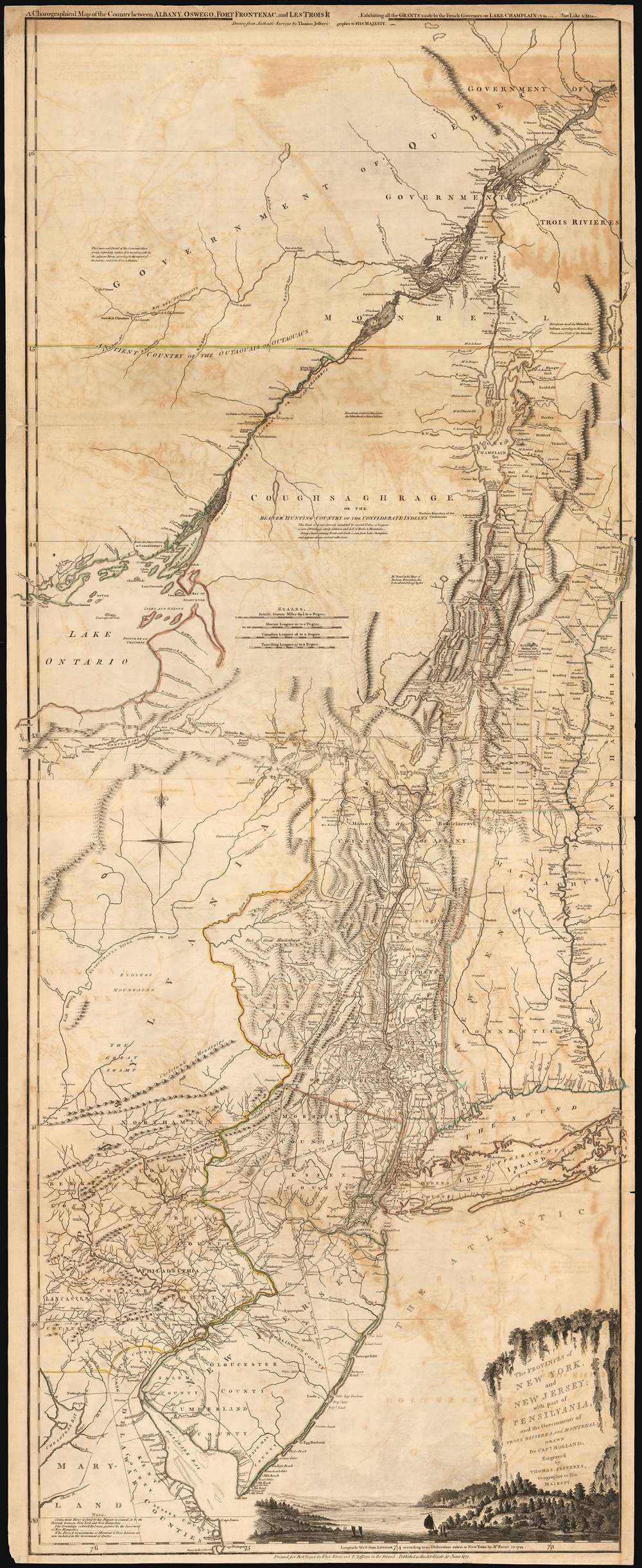
The Provinces of NEW YORK, and NEW JERSEY; with part of PENSILVANIA, and the Governments of TROIS RIVIERES, and MONTREAL: drawn by Capt. Holland. / A Chorographical Map of the Country between Albany, Oswego, Fort Frontenac, and Les Trois Rivieres; Exhibiting all the Grants made by the French Governors on Lake Champlain; and between that Lake and Montreal.
1775 (dated) 53 x 21 in (134.62 x 53.34 cm) 1 : 633300
1775 (dated) 53 x 21 in (134.62 x 53.34 cm) 1 : 633300
Description
One of the most important, influential, and comprehensive American Revolutionary War Era maps of New York, New Jersey, Vermont, and the Hudson Valley corridor, this is an early 1775 edition of Capt. Samuel Holland and Thomas Jeffrey's Provinces of New York and New Jersey… Holland's map illustrates the important strategic and trade corridor between New York and Montreal, specifically detailing from Delaware Bay northward including parts of eastern Pennsylvania, New Jersey, Long Island, New York, Connecticut, Massachusetts and Vermont as well as the Iroquois League, the Trois Rivieres territories, and Montreal, as far as Lac St. Pierre in modern-day Quebec. In the lower right, a scenic cartouche illustrates the wide and easily navigable expanse of the Hudson River - surely an enticement to the region.
The Holland Surveys
Holland completed the initial surveys for this map in 1767 and 1768 as part of his role as New York - New Jersey Boundary Commissioner. New York and New Jersey were at the time disputing their north-western border, particularly in the vicinity of Morris County (currently New Jersey). Holland was commissioned by the Board of Trade to produce a new survey elaborating on the points of contention. This resulted in a manuscript map (now lost) that was presented to the Board of Trade in 1768.Jefferys' Proactivity - Preparing for War
Thomas Jefferys, as Geographer to the King, was among the first to have access to Holland's map and would have had the right to use it without Holland's permission. As Powell suggests, it is likely that the 'Name of Capt. Holland is put, without his Knowledge or Consent.' Jefferys incorporated this valuable cartographic data into a new and expansive map that detailed not only the New York - New Jersey border region, but the entire Hudson Valley as far north as Montreal. In order to expand the map northward beyond the scope of Holland's surveys, Jefferys relied on the cartography established by Lewis Evans (Hudson Valley, Lake Ontario) and Cadwallader Colden (St. Lawrence region). The proto-Vermont land grants are also noted. There can be little doubt that Jefferys was aware of the anti-colonial sentiment brewing in the New England colonies and thus recognized the imminent need for a new, highly accurate, large scale map of what he correctly foresaw as the seat of the upcoming conflict.Publication History and Census
The present map represents the second state of this important map. All states are uncommon, but the first two states, which are cartographically identical, are exceptional and rarely appear on the market. Here is a breakdown:- 1768 - Preliminary State. No difference in the printing from the First State, but the colorist presents a different New York - New Jersey Border.
- 1768 - First state. No insets in the upper quadrants, no date on imprint.
- June 15, 1775 - Second State (current example). Robert Sayer imprint added. Dated June 15, 1775 at bottom.
- December 20, 1775 - Third State. Dated as such at the bottom of the map. The title at the top of the map 'Corographical…' has been removed. Inset maps of New York City, Albany, and the mouth of the Hudson River have been added at the top of the map.
- August 17, 1776 - Fourth State. Holland's rank changed to 'Major'. New information attributed to Governor Pownall added. Imprint changed to Sayer and Bennet. Dated August 17, 1776.
- August 17, 1776 - Fifth State. Jefferys name is removed from the plate. Dated at bottom.
CartographerS
Samuel Holland (1728 - December 28, 1801) was a surveyor and cartographer of extraordinary skill and dedication. Holland was born in the Netherlands in 1728 and, at 17, joined the Dutch Army where he attained the rank of Lieutenant. Around 1754 Holland emigrated to England where he joined the newly forming Royal American Regiment. His skills as a cartographer and surveyor brought him to the attention of his superiors who offered him steady promotions. In 1760 he prepared an important survey of the St. Lawrence River system. It was during this survey that Holland met a young James Cook, who he mentored in the art of surveying. Cook, best known for his exploration of the Pacific, developed many of his own revolutionary nautical surveying techniques based the systems he learnt from Holland. In 1762 Holland caught the attention of the Commission of Trade and Plantations, who governed the British Crown Colonies in America. Under the umbrella of the Trade Commission Holland prepared surveys of the Hudson River Valley and other New York properties. In 1764 he was named Surveyor General for the Northern District, the position in which he did much of his most important work. Holland is also known for surveying done in an attempt to sort out the New York - New Jersey border conflict. Following his work in New York Holland relocated to Canada where, with his new wife of just 21 years, he sired seven children. Like many early surveyors working for colonial governments, Holland was poorly compensated and is known to have supplemented his income by selling the results of his surveys, and those of other surveyors to which he had privileged access, to private publishers, among them the London firm of Laurie and Whittle, who published his work under the pseudonym of 'Captain N. Holland.' Samuel Holland died in Quebec in 1801. More by this mapmaker...
Thomas Jefferys (1695 - November 20, 1771) was one of the most prominent and prolific map publishers and engravers of his day. Jefferys was born in Birmingham and was apprenticed to the engraver Emmanuel Bowen in 1735. Later, in the 1740s he engraved several maps for the popular periodical Gentleman's Magazine. Around 1740 Jefferys was finally able to go into business for himself and in 1746 received an appointment as 'Geographer to Fredrick, Prince of Wales,' which shortly after translated to the position of 'Royal Cartographer to King George III.' Jefferys initially specialized in compiling and re-engraving the works of earlier cartographers into more coherent cartographic wholes. Later, while not salaried position, Jefferys' appointment as 'Royal Cartographer' guaranteed preferential access to the most up to date cartographic material available, allowing him to produce new and updated charts of exceptional accuracy. He his best known for his maps of the Americas, particularly the posthumously published 1775 American Atlas, which included some of the finest and most important late colonial era maps of America ever made. Despite his prolific publishing history, royal appointments, and international publishing fame, Jefferys lived most of his life in dire economic straits. He was bailed out of bankruptcy by Robert Sayer during the production of the American Atlas. In the end, Jefferys died suddenly with very little to his name. Nonetheless, his cartographic legacy survived, and even after his death in 1771, many of his important maps continued to be published and republished by Sayer and Bennet, Conrad Lotter, Georges Louis Le Rouge, Laurie and Whittle, and others. Many attribute some of Jefferys best maps to the colorful and criminally inclined Irish cartographic genius Braddock Mead (John Green, c. 1688 - 1757), who is considered the 'secret behind Jefferys.' Jefferys was succeeded by his son, also Thomas, who had little success as a cartographer and eventually partnered with, then sold his stock and plates to William Faden - Jefferys' true heir. Learn More...
Robert Sayer (1725 - January 29, 1794) was an important English map publisher and engraver active from the mid to late 18th century. Sayer was born in Sunderland, England, in 1725. He may have clerked as a young man with the Bank of England, but this is unclear. His brother, James Sayer, married Mary Overton, daughter-in-law of John Overton and widow of Philip Overton. Sayer initially worked under Mary Overton, but by December of 1748 was managing the Overton enterprise and gradually took it over, transitioning the plates to his own name. When Thomas Jefferys went bankrupt in 1766, Sayer offered financial assistance to help him stay in business and, in this way, acquired rights to many of the important Jefferys map plates as well as his unpublished research. From about 1774, he began publishing with his apprentice, John Bennett (fl. 1770 - 1784), as Sayer and Bennett, but the partnership was not formalized until 1777. Bennett retired in 1784 following a mental collapse and the imprint reverted to Robert Sayer. From 1790, Sayer added Robert Laurie and James Whittle to his enterprise, renaming the firm Robert Sayer and Company. Ultimately, Laurie and Whittle partnered to take over his firm. Sayer retired to Bath, where, after a long illness, he died. During most of his career, Sayer was based at 53 Fleet Street, London. His work is particularly significant for its publication of many British maps relating to the American Revolutionary War. Unlike many map makers of his generation, Sayer was a good businessman and left a personal fortune and great estate to his son, James Sayer, who never worked in the publishing business. Learn More...
Condition
Good. Some marginal repairs and fill especially along top border where there is some loss to the secondary title. Verso reinforcements at folds, few surface mends.
References
Rumsey 0346.020 (1776 edition). OCLC 919177605. Allen, David Y., 'Comparing Eighteenth-Century Map of New York State Using Digital Imagery'. Schwarz, Philip J., The Jarring Interests New York's Boundary Makers, 1664-1776, p. 133 - 190. Tooley, R. V. The Mapping of America, #44. Library of Congress, G3800 1768 .H6 Vault (1868 edition). New York Public Library, Map Div. 97-6176 [LHS 815], Map Div. 01-5334 (similar NJ-NY border). Phillips, Maps of America, p. 502; Phillips 1196. McCorkle (#768.3, 775.6, 776.13). Sellers and van Ee (#1039-40, 1042-43, 1045-46). Ristow, Walter W., American Maps and Mapmakers, page 52.