Digital Image: 1777 Lotter and Sauthier Map of New York and New Jersey
NewYorkNewJersey-lotter-1777-2_d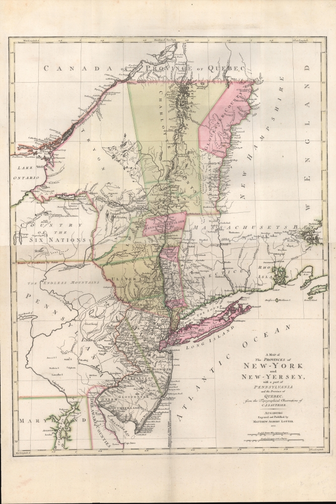

Title
A Map of The Provinces of New-York and New-Jersey, with a part of Pennsylvania and the Province of Quebec from the Topographical Observations of C. J. Sauthier.
1777 (dated) 30 x 23 in (76.2 x 58.42 cm) 1 : 1000000
1777 (dated) 30 x 23 in (76.2 x 58.42 cm) 1 : 1000000
Description
FOR THE ORIGINAL ANTIQUE MAP, WITH HISTORICAL ANALYSIS, CLICK HERE.
Digital Map Information
Geographicus maintains an archive of high-resolution rare map scans. We scan our maps at 300 DPI or higher, with newer images being 600 DPI, (either TIFF or JPEG, depending on when the scan was done) which is most cases in suitable for enlargement and printing.
Delivery
Once you purchase our digital scan service, you will receive a download link via email - usually within seconds. Digital orders are delivered as ZIP files, an industry standard file compression protocol that any computer should be able to unpack. Some of our files are very large, and can take some time to download. Most files are saved into your computer's 'Downloads' folder. All delivery is electronic. No physical product is shipped.
Credit and Scope of Use
You can use your digial image any way you want! Our digital images are unrestricted by copyright and can be used, modified, and published freely. The textual description that accompanies the original antique map is not included in the sale of digital images and remains protected by copyright. That said, we put significant care and effort into scanning and editing these maps, and we’d appreciate a credit when possible. Should you wish to credit us, please use the following credit line:
Courtesy of Geographicus Rare Antique Maps (https://www.geographicus.com).
How Large Can I Print?
In general, at 300 DPI, you should at least be able to double the size of the actual image, more so with our 600 DPI images. So, if the original was 10 x 12 inches, you can print at 20 x 24 inches, without quality loss. If your display requirements can accommodate some loss in image quality, you can make it even larger. That being said, no quality of scan will allow you to blow up at 10 x 12 inch map to wall size without significant quality loss. For more information, it is best consult a printer or reprographics specialist.
Refunds
If the high resolution image you ordered is unavailable, we will fully refund your purchase. Otherwise, digital images scans are a service, not a tangible product, and cannot be returned or refunded once the download link is used.
Cartographer S
Claude Joseph Sauthier (November 10, 1736 - 1802) was a French born surveyor, cartographer, and draftsman active in the British Colonies in North America just prior to the American Revolutionary War. Sauthier was born in Strasbourg, France, where he trained under Dezallier d'Agenvie and Jean Baptiste Alexandre le Blond as a garden designer and draftsman. He migrated to America in 1767 at the request of North Carolina royal governor William Tyron who was perhaps familiar with his book, A Treatis on Public Architecture and Garden Planning. Sauthier mapped much of the province of North Carolina before being promoted to the office of Surveyor of the Province of New York. Sauthier oversaw the surveying of numerous regional and provincial boundary disputes before the outbreak of the American Revolutionary War. During the Revolutionary War he was reassigned to the British Corps of Engineers, preparing an important survey for General Howe of New York and another of Staten Island. Sauthier was later attached to the staff of General Hugh Percy, who commanded the British Forces in Rhode Island. When Percy retired to his family estate, Alnwick Castle, in England, Sauthier accompanied him as a personal secretary. Ultimately, after a long, impactful, and adventurous career, Sauthier returned to his hometown of Strasburg where resided until his death on November 26, 1802. He was 66. More by this mapmaker...
Tobias Conrad Lotter (1717 - 1777) was a German engraver and map publisher. Lotter was the son of a baker and city guardsman, but married Euphrosina (1709 - 1784) Seutter, elder daughter of the prominent map publisher Matthäus Seutter. He began working at his is father-in-law's map business about 1740. Between 1740 and 1744 he produced, under Seutter's imprint, the Atlas minor, Praecipua orbis terrarum imperia, regna et provincias, Germania potissimum tabelli. Upon Seutter's death, in 1757, the firm's stock was taken over by his son, Albrecht Karl Seutter (1722 - 1762), who himself died in 1762, just a few years later. The remaining Seutter map plates were subsequently divided between Lotter and the publisher Johan Mitchell Probst (1727 - 1776). With the support of his sons, Matthäus Albrecht (1741 - 1810), Georg Friedrich (1744 - 1801) and Gustav Conrad (1746-1776), Tobias Conrad Lotter succeeded in building on the economic success and professional reputation of his father-in-law. In time, Lotter became one of the most prominent mid-18th century map publishers working in the German school. After Lotter's death in 1777, the business was taken over by his two eldest sons, who, lacking their father's business acumen, presided over the firm's slow decline. It was nonetheless passed on to a subsequent generation of Lotters, Matthäus Albrecht Lotter's sons, Gabriel (1776 - 1857) and Georg Friedrich (1787 - 1864), who pushed it into further decline until it faded out in the early-19th century. Learn More...
Source
Seutter, M., Grosser Atlas, (Augsburg: Lotter) 1778. Also, Seutter, M., Atlas Novus, (Augsburg: Lotter) 1778.