Digital Image: 1939 U.S. Army Topo Engineers Map of West Point and Vicinity, New York
NewYorkWestPoint-topoengin-1939_d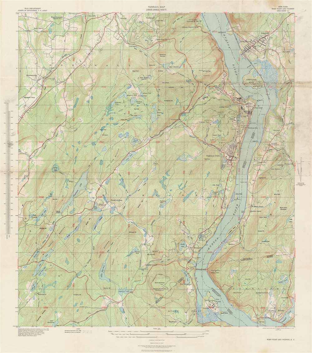

Title
Terrain Map. New York West Point and Vicinity.
1939 (dated) 36 x 31 in (91.44 x 78.74 cm) 1 : 20000
1939 (dated) 36 x 31 in (91.44 x 78.74 cm) 1 : 20000
Description
FOR THE ORIGINAL ANTIQUE MAP, WITH HISTORICAL ANALYSIS, CLICK HERE.
Digital Map Information
Geographicus maintains an archive of high-resolution rare map scans. We scan our maps at 300 DPI or higher, with newer images being 600 DPI, (either TIFF or JPEG, depending on when the scan was done) which is most cases in suitable for enlargement and printing.
Delivery
Once you purchase our digital scan service, you will receive a download link via email - usually within seconds. Digital orders are delivered as ZIP files, an industry standard file compression protocol that any computer should be able to unpack. Some of our files are very large, and can take some time to download. Most files are saved into your computer's 'Downloads' folder. All delivery is electronic. No physical product is shipped.
Credit and Scope of Use
You can use your digial image any way you want! Our digital images are unrestricted by copyright and can be used, modified, and published freely. The textual description that accompanies the original antique map is not included in the sale of digital images and remains protected by copyright. That said, we put significant care and effort into scanning and editing these maps, and we’d appreciate a credit when possible. Should you wish to credit us, please use the following credit line:
Courtesy of Geographicus Rare Antique Maps (https://www.geographicus.com).
How Large Can I Print?
In general, at 300 DPI, you should at least be able to double the size of the actual image, more so with our 600 DPI images. So, if the original was 10 x 12 inches, you can print at 20 x 24 inches, without quality loss. If your display requirements can accommodate some loss in image quality, you can make it even larger. That being said, no quality of scan will allow you to blow up at 10 x 12 inch map to wall size without significant quality loss. For more information, it is best consult a printer or reprographics specialist.
Refunds
If the high resolution image you ordered is unavailable, we will fully refund your purchase. Otherwise, digital images scans are a service, not a tangible product, and cannot be returned or refunded once the download link is used.
Cartographer
Army Corps of Topographical Engineers (fl.1838 - 1863) refers to the an elite branch of the U.S. Army created on July 4, 1838 to perform civil mapping and survey work throughout the United States. The origins of the Corps of Topographical Engineers can be traced back to the American Revolutionary War, where General George Washington recognized the need for accurate surveys pursuant to military action. Shortly following the war, in 1779, a civilian engineering corps was created by act of Congress. Identified in 1802 by Thomas Jefferson, the "Corps of Engineers," which was based at West Point, the group participated in the War of 1812 and in later in the fortification of New Orleans. It was not until 1838, however, that a separate group of "Topographical Engineers" was formally recognized. This elite group, consisting only of officers, most of whom were trained in surveying and engineering by the esteemed Andrew Ellicott at West Point, never numbered more than 36 individuals - the best and brightest. This small but determined group played a central role in the mapping and exploration of the American West. Few branches of the military can boast such a distinguished alumni. Their names resonate throughout the map of the west and include John Charles Fremont, Zebulon Pike, George Meade, Kemble Warren, William Amiel Weeks, A. B. Gray, Randolph B. Marcy, James H. Simpson, Howard Stansbury, John W. Gunnison, William Ludlow, and Robert S. Williamson. The onset of the American Civil War brought an abrupt end to the surveying activity of the Topographical Engineers. Many of the most prominent engineers went on to distinguished military careers on both sides of the War Between the States. The Army Corps of Topographical Engineers itself was folded into the Corps of Engineers on March 31, 1863. Though the Army Corps of Engineers continues to do military and civil survey work to this day, the elite club of adventures that formed the Topographical Engineers were no more. More by this mapmaker...