Digital Image: 1824 Klinkowstrom View of New York City from Brooklyn
NewYorksHamnochRedd-muller-1824-2_d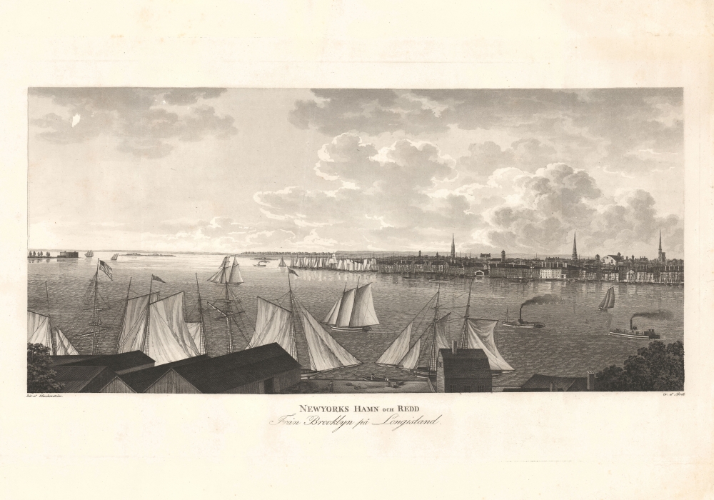

Title
Newyorks Hamn och Redd Fran Brooklyn pa Longisland.
1824 (undated) 10 x 19 in (25.4 x 48.26 cm)
1824 (undated) 10 x 19 in (25.4 x 48.26 cm)
Description
FOR THE ORIGINAL ANTIQUE MAP, WITH HISTORICAL ANALYSIS, CLICK HERE.
Digital Map Information
Geographicus maintains an archive of high-resolution rare map scans. We scan our maps at 300 DPI or higher, with newer images being 600 DPI, (either TIFF or JPEG, depending on when the scan was done) which is most cases in suitable for enlargement and printing.
Delivery
Once you purchase our digital scan service, you will receive a download link via email - usually within seconds. Digital orders are delivered as ZIP files, an industry standard file compression protocol that any computer should be able to unpack. Some of our files are very large, and can take some time to download. Most files are saved into your computer's 'Downloads' folder. All delivery is electronic. No physical product is shipped.
Credit and Scope of Use
You can use your digial image any way you want! Our digital images are unrestricted by copyright and can be used, modified, and published freely. The textual description that accompanies the original antique map is not included in the sale of digital images and remains protected by copyright. That said, we put significant care and effort into scanning and editing these maps, and we’d appreciate a credit when possible. Should you wish to credit us, please use the following credit line:
Courtesy of Geographicus Rare Antique Maps (https://www.geographicus.com).
How Large Can I Print?
In general, at 300 DPI, you should at least be able to double the size of the actual image, more so with our 600 DPI images. So, if the original was 10 x 12 inches, you can print at 20 x 24 inches, without quality loss. If your display requirements can accommodate some loss in image quality, you can make it even larger. That being said, no quality of scan will allow you to blow up at 10 x 12 inch map to wall size without significant quality loss. For more information, it is best consult a printer or reprographics specialist.
Refunds
If the high resolution image you ordered is unavailable, we will fully refund your purchase. Otherwise, digital images scans are a service, not a tangible product, and cannot be returned or refunded once the download link is used.
Cartographer S
Axel Leonhard Klinckowström (February 25, 1775 - June 7, 1837) was a Swedish Baron active in the late 18th and early 19th century. Klinckowström was born in Stockholm, the eldest son of Baron Thure Leonard Klinckowström. Although born with an artistic temperament, he he was nonetheless pressured by his ambitious father towards a military life. He joined the Swedish navy as an ensign at 17 and rose, in the course of a long career, to the rank of Lieutenant-Colonel. It was most likely Klinkowström's skills as an artist that lead his superiors to send him to America. Between 1818 and 1820, Klinkowström traveled to the United States to investigate the American invention of the steamboat and assess its military potential for the Swedish navy. During his American tour Klinkowström composted some 25 illustrated letters which were published in 1824, roughly four years after his return to Sweden, as Bref om de Förenta Staterna. The compilation not only offered practical advice for the military, merchants, and gentleman travelers, but contained numerous aquatints based on Klinkowström's drawings and offered a Tocqueville-esque commentary on American culture. More by this mapmaker...
Carl Fredrik Akrell (January 13, 1779 - December 11, 1868) was a Swedish military cartographer and engraver active in the early 20th century. Akrell was born in Uppsala, Sweden to a middle class family. He joined the military as a young man and exhibiting proficiency with mathematics was assigned to the survey department where he worked under Gustave Wilhelm af Tibell. He participated in the fortification of the Stockhom archipelago and fought with distinction in the battles of Gross-Beeren, Dannewits, and Leipzig. Following a distinguished showing in the battle of Leipzig, Akrell was honored as a "Knight of the Sword" and adopted into the nobility. In time Akrell attained the rank of Major General. Cartographically Akrell is best known for his engraved maps of Stockholm and the aquatints he etched for Jean Baptiste Le Chevalier's Trip Propontiden and Black Se and Axel Leonhard Klinckowström Bref om de Förenta Staterna. Learn More...
Source
Muller, C., Atlas til Friherre Klinckowstroms Bref om de Forente Staterne, (Stockholm: C. Muller) 1824.