1913 U.S. Geological Survey Areal Geology Map of Niagara County, New York
NiagaraArealGeo-usgs-1913$175.00

Title
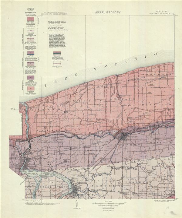
New York. Niagara Quadrangle. Areal Geology.
1913 (dated) 21 x 18 in (53.34 x 45.72 cm) 1 : 125000
1913 (dated) 21 x 18 in (53.34 x 45.72 cm) 1 : 125000
Description
This is a fine 1913 U.S. Geological Survey map depicting the areal geology of the Niagara County (including the Niagara River and the Niagara Falls), New York. The map shows the distribution of the different types of rocks or geological formations of the region, covering from Lake Ontario to Tonawanda and from Niagara Falls in Ontario, Canada and the Niagara River east as far as Newstead. The map notes several towns, rivers, railroads, roads, buildings, bridges, and a host of additional features. A legend is included in the top left quadrant of the map. This map is based on geology survey conducted by E.M. Kindle and G. K. Gilbert in 1897, 98 and 1909. Topography is by U.S. Lake Survey, Frank Sutton, E. B. Clark and J. H. Wheat surveyed in 1893 and 1896 in cooperation with the state of New York, with triangulation by U.S. Land Survey under the supervision of H.M. Wilson, Geographer in charge. Issued in 1913 by the U.S. Geological Survey with George Otis Smith, Director, as part of Geological Atlas of the United States, Niagara Folio, New York, by E.M. Kindle and Frank. B. Taylor.
Cartographer
The Office of the Coast Survey (later the U.S. Geodetic Survey) (1807 - present), founded in 1807 by President Thomas Jefferson and Secretary of Commerce Albert Gallatin, is the oldest scientific organization in the U.S. Federal Government. Jefferson created the "Survey of the Coast," as it was then called, in response to a need for accurate navigational charts of the new nation's coasts and harbors. The first superintendent of the Coast Survey was Swiss immigrant and West Point mathematics professor Ferdinand Hassler. Under the direction of Hassler, from 1816 to 1843, the ideological and scientific foundations for the Coast Survey were established. Hassler, and the Coast Survey under him developed a reputation for uncompromising dedication to the principles of accuracy and excellence. Hassler lead the Coast Survey until his death in 1843, at which time Alexander Dallas Bache, a great-grandson of Benjamin Franklin, took the helm. Under the leadership A. D. Bache, the Coast Survey did most of its most important work. During his Superintendence, from 1843 to 1865, Bache was steadfast advocate of American science and navigation and in fact founded the American Academy of Sciences. Bache was succeeded by Benjamin Pierce who ran the Survey from 1867 to 1874. Pierce was in turn succeeded by Carlile Pollock Patterson who was Superintendent from 1874 to 1881. In 1878, under Patterson's superintendence, the U.S. Coast Survey was reorganized as the U.S. Coast and Geodetic Survey (C & GS or USGS) to accommodate topographic as well as nautical surveys. Today the Coast Survey is part of the National Oceanic and Atmospheric Administration or NOAA. More by this mapmaker...
Source
U.S. Geological Survey, Geological Atlas of the United States, Niagara Folio, New York, by E.M. Kindle and Frank. B. Taylor, Washington D.C., 1913.
Condition
Very good. Blank on verso.