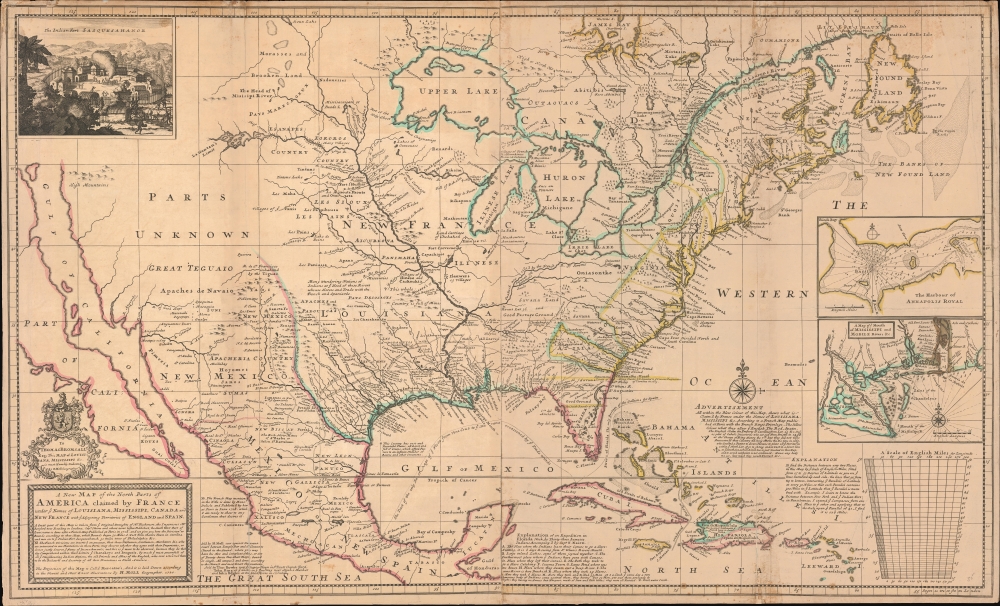
This is Herman Moll's 1720 map of North America, with original color. It was issued as part of an ongoing cartographic debate between French and British mapmakers regarding claims in the little-understood interior. The map is Moll's attempt to enflame outrage against Guillaume Delisle's 1718 pro-French map of the same. In addition, the map features several interesting cartographic elements, including a significant correction to the Great Lakes, the ephemeral Margravate of Azilia (Georgia), and a representation of California as an Island.
A Closer Look
Coverage embraces roughly the modern-day contiguous United States, extending from Atlantic to Pacific and from the Great Lakes to the West Indies, including all of Mexico and parts of modern-day Canada as far as the Hudson Bay and the Canadian Maritimes. The map's focus is the three primary colonial empires dominating North America - the Spanish (red), French (blue), and English (yellow). Moll was attempting to enflame his readers with the 'egregious' encroachments of the hated French upon English plantations. Consequently, the borders here correspond to those laid down in 1718 by the French geographer Guillaume Delisle (1675 - 1726). As written on the map,
The French Divisions are inserted on purpose, that those Noblemen, Gentleman, Merchants and c. who are interested in our Plantations in those Parts, my observe whether they agree with their Proprieties, or do not justly deserve ye Name of incroachments [sic]; and this is ye more to be observed, because they do thereby Comprehend within their Limits ye Charakeys [sic] and Iroquois, by much ye most powerfull [sic] of all ye neighbouring [sic] Indian Nations, and the old Friends and Allies of the English, who ever [sic] esteemed them to be the Bulwark and Security of all their Plantations in North America.
In other words, Moll was trying to stir up trouble. The French at this time were aggressively attempting to build relationships with Britain's American Indian allies in the eastern Mississippi Valley. The British relied on these nations, particularly the Iroquois League and the Cherokee, as a trading partners and a buffer zone against French Louisiana. From the French perspective, controlling North America's primary waterways, including the St. Lawrence, the Great Lakes, the Mississippi, and the Ohio, meant controlling the continent. Conflict over this region eventually devolved beyond academic debates into the French and Indian War (1754 - 1763).
Margravate of Azilia
This is one of the few maps to include the Margravate of Azilia, a proto-Georgia colony proposed in 1717 by Baronet Sir Robert Montgomery (1680 - 1731). Montgomery received a grant from the Lords Proprietors of Carolina for territory between the Savannah and Altamaha Rivers. These rivers he planned to line with fortified redoubts, which he believed would make the colony safe from the depredations of both the Spanish in Florida and their American Indian allies. If these were not enough, he planned to build the colony around an enormous, fortified city - Azilia. Azilia was to be divided into 116 gracious squares of 640 acres each; there were also four massive game reserves, a sprawling private estate at the center for the Margrave, and ample public fields, all contained within gigantic fortifications. The city, as envisioned by Mongomery, would have been about 289 square miles, nearly the size of modern-day New York! Azilia gained little traction outside of intellectual circles and Montgomery himself died in 1731. James Oglethorpe (1696 - 1785) wasted no time in petitioning the crown for his own grant to the same region. In 1732, King George II granted Oglethorpe a Royal Charter to create 'Georgia'. Comparing the prospective city plans of Azilia with the early plans for (and current configuration of) Savannah, it is clear that Oglethorpe was inspired by Azilia, if more practical in his ambitions.
Narine's Journey through Florida
The map includes a most interesting depiction of Florida's interior derived from the otherwise little-known adventures of Thomas Nairne (16?? - 1715), a Scottish trader and the first Indian agent of the Province of Carolina. While Florida was technically Spanish territory, beyond the narrow areas controlled by St. Augustine, it remained a poorly understood no man's land, mired in impenetrable swamp and populated scattered American Indian communities. Moreover, the ongoing War of Spanish Succession (1701 - 1714) gave British colonials a carte blanche to terrorize Florida. And so Indian Agent Narine traveled deep into Florida in 1702 to harass, eradicate, or capture Spanish-allied Yamassee Indians. He slaughtered many and successfully took 35 captives, which he sold into slavery in Charles Town. Nairne wrote in 1705, 'We have these … past two years been entirely kniving [sic] all the Indian Towns in Florida which were subject to the Spaniards.' (Moore,
Nairne's Muskhogean Journals, page 8.)
Insular California
This is one of the last published maps to include California as an island. Moll is said to have made the bold claim that, without a doubt, 'California is an Island' and that he 'had in [his] office mariners who have sailed round it.' The idea of an insular California first appeared as a work of fiction in Garci Rodriguez de Montalvo's c. 1510 romance
Las Sergas de Esplandian, where he writes
Know, that on the right hand of the Indies there is an island called California very close to the side of the Terrestrial Paradise; and it is peopled by black women, without any man among them, for they live in the manner of Amazons.
Baja California was subsequently discovered in 1533 by Fortun Ximenez, who had been sent to the area by Hernan Cortez. When Cortez himself traveled to Baja, he must have had Montalvo's novel in mind, for he immediately claimed the 'Island of California' for the Spanish King. By the late 16th and early 17th century, ample evidence had been amassed, through explorations of the region by Francisco de Ulloa, Hernando de Alarcon, and others, that California was, in fact, a peninsula. Nonetheless, by this time, other factors were in play. Francis Drake had sailed north and claimed Nova Albion, modern-day Washington or Vancouver, for England. The Spanish thus needed to promote Cortez's claim on the 'Island of California' to preempt English claims on the western coast of North America. The significant influence of the Spanish crown on European cartographers spurred a major resurgence of the Insular California theory.
Publication History and Census
This map was engraved (possibly by) Hermann Moll in 1720. There are at least six states, which are poorly cataloged. The present state, updated with the imprint of Thomas Bowles, John King, and John Bowles, is the 4th state. Moll issued the map both separately and in his
New and Compleat Atlas. Most examples that come to market are in poor condition as a result of low-quality paper, the tri-fold metric of the
New and Compleat Atlas, their large size, and poor binding. Both the map and atlas are well represented in institutional collections but scarce to the market.
Cartographer
Herman Moll (1654 - 1732) was an important 18th century map publisher and engraver based in London and Holland. Moll's origins are disputed with some suggesting he was born in the Netherlands and others Germany - the Moll name was common in both countries during this period. Most likely Moll was a German from Bremen, as his will, friends, and contemporaries suggest. What is known for certain is that he moved to London in 1678, possibly fleeing the Scanian War, where he worked as an engraver for Moses Pitt and other London map publishers. Around the turn of the century, Moll set up his own shop where he produced a large corpus of work known for its high quality and decorative flair. As a new émigré to England, Moll made himself more English than the English, and through his cartography proved a fierce advocate for his adopted nation. Most of Moll's early maps were issued as loose sheets that would be bound to order, however, he did publish several important atlases late in his career. Moll is said to have made the bold claim that without a doubt "California is an Island" and that he "had in [his] office mariners who have sailed round it." While California may not be an island (yet), it is true that moll had talent for attracting interesting friends and acquaintances. He frequented London's first stock exchange, Jonathan's Coffeehouse at Number 20 Exchange Alley, Cornhill. At the time Jonathan's was known as "a place of very considerable concourse for Merchants, sea faring Men and other traders" (Erleigh, The Viscount, The South Sea Bubble, Manchester: Peter Davies, Ltd., 1933, 21). Eventually this activity attracted the interest of stock brokers, who inspired by sailor's tales, sponsored the ill-fated South Sea Company, the world's first stock bubble. Moll's close circle, mostly from the Coffee House, included scientist Robert Hooke, the writers Daniel Defoe (Robinson Crusoe) and Jonathan Swift (Gulliver's Travels), the pirates William Dampier, William Hacke and Woodes Rogers, and the archeologist William Stukeley. Herman Moll's work was highly regarded for its decorative beauty and was pirated, most notably by the Irish publisher George Grierson, both in his lifetime and after his 1732 death at St. Clement Danes, London. More by this mapmaker...
Good. Has condition issues typical of this map, including edge wear and fold wear, with some repaired spits along original fold lines. Edges reinforced on verso all sides. The present example, with restoration limited to stabilization of the usual fold weakness and splits, with original color, is in above-average condition compared to most examples that have not been submitted to heavy restoration.
OCLC 48075120. McLaughlin, G., The Mapping of California as an Island: An Illustrated Checklist, #197. Reinhartz, D. 'Herman Moll, Geographer: An Early Eighteenth-Century European View of the American Southwest', in The Mapping of the American Southwest, ed. Dennis Reinhartz and Charles C. Colley, p. 32-33. Cumming, W., The Southeast in Early Maps, p. 43-44. Prichard, M. B., and Taliaferro, H. G., Mapping Colonial America Degrees of Latitude, #21.