Digital Image: 1804 Reichard Map of North America w/ state of Franklinia
NorthAmerica-reichard-1804-2_d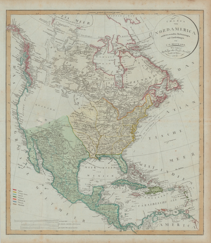

Title
Charte von Nord America nach en neuesten Bestimmungen und Entdeckungen.
1804 (dated) 24 x 21 in (60.96 x 53.34 cm) 1 : 13000000
1804 (dated) 24 x 21 in (60.96 x 53.34 cm) 1 : 13000000
Description
FOR THE ORIGINAL ANTIQUE MAP, WITH HISTORICAL ANALYSIS, CLICK HERE.
Digital Map Information
Geographicus maintains an archive of high-resolution rare map scans. We scan our maps at 300 DPI or higher, with newer images being 600 DPI, (either TIFF or JPEG, depending on when the scan was done) which is most cases in suitable for enlargement and printing.
Delivery
Once you purchase our digital scan service, you will receive a download link via email - usually within seconds. Digital orders are delivered as ZIP files, an industry standard file compression protocol that any computer should be able to unpack. Some of our files are very large, and can take some time to download. Most files are saved into your computer's 'Downloads' folder. All delivery is electronic. No physical product is shipped.
Credit and Scope of Use
You can use your digial image any way you want! Our digital images are unrestricted by copyright and can be used, modified, and published freely. The textual description that accompanies the original antique map is not included in the sale of digital images and remains protected by copyright. That said, we put significant care and effort into scanning and editing these maps, and we’d appreciate a credit when possible. Should you wish to credit us, please use the following credit line:
Courtesy of Geographicus Rare Antique Maps (https://www.geographicus.com).
How Large Can I Print?
In general, at 300 DPI, you should at least be able to double the size of the actual image, more so with our 600 DPI images. So, if the original was 10 x 12 inches, you can print at 20 x 24 inches, without quality loss. If your display requirements can accommodate some loss in image quality, you can make it even larger. That being said, no quality of scan will allow you to blow up at 10 x 12 inch map to wall size without significant quality loss. For more information, it is best consult a printer or reprographics specialist.
Refunds
If the high resolution image you ordered is unavailable, we will fully refund your purchase. Otherwise, digital images scans are a service, not a tangible product, and cannot be returned or refunded once the download link is used.
Cartographer S
Christian Gottleib Reichard (June 6, 1758 - September 11, 1837) was a Weimar based German cartographer active in the late 18th and early 19th centuries. He was educated at the Lyceum of Schleiz and studied law at the University of Leipzig. Reichard developed an early interest in geography, drawing, and music, which he continued to develop throughout his life. His first cartographic project was a globe made for his children, which attracted the interest Baron Franz Xaver von Zach in Gotha. With Zach's support Reichard delved more fully into cartography, publishing several important works early in the 19th century focusing on the discoveries of Mungo Parke, Rennel, Lander, and Alexander von Humboldt. He also supplied several charts to the Homann Heirs firm. Along with Adolf Stieler and the Perthes publishing companies, he collaborated on the first Stieler's Handlatlas. Published between 1817 and 1823, the first Stieler's Handlatlas proved to be a long lived and influential work that continued to be revised and updated well into the 20th century. In addition, he also published several general and historical atlases on his own account between 1803 and 1824. More by this mapmaker...
Geographisches Institut, Weimar (fl. 1804 - c. 1903) was a German map and globe publishing house and geographical research institute based in Weimar. The organization primarily focused on republishing and improving upon the works of earlier cartographers, including Kitchin, Jefferys, Carey, and others. In general, its publications are known for their fine engraving, attention to detail, historical accuracy, and overall high quality. The firm was founded in 1804 by Friedrich Justin Bertuch (???? - c. 1845) and, on his death, passed to his son Robert Froreip (???? - 1855), then to Louis Denicks of Luneberg, then in 1859 to Voigt & Günther, in 1883 to F. Arnd, from 1890 - 1893 to Julius Kettler, and in 1903 to Max Wedekind. During the institute's height in the early 19th century, most of its cartographic publication was overseen by Carl Ferdinand Weiland (1782 - 1847). The firm also employed the cartographers Franz Xaver von Zach, Adam Christian Gaspari, Heinrich Kiepert, Karl (or Carl) and Adolf Graef, Julius Kettler, Carl Riemer and Karl Christian Bruhns. Weimar was a logical place for a collective like the Geographisches Institut to arise; it was a cultural mecca in the German-speaking world in the late 18th and 19th centuries because of its liberal atmosphere and associations with figures like Schiller, Herder, and, above all, Goethe, who spent most of his adult life in the city. Learn More...
Source
Reichard, C. G., Allgemeiner Hand-Atlas der Ganzen Erde, (Weimar: Geographischen Institutes Weimar) 1804.
References
OCLC 42207337, 41589584.