Digital Image: 1763 Benjamin Webb Manuscript Map of the British Empire in North America
NorthAmerica-webb-1763_d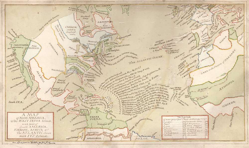

Title
A Map of North America, and the West India Islands, with part of South America, Europe, Africa and The Atlantic Ocean with It's Islands von Benjamin Webb gezeichnet.
1763 (undated) 10.5 x 18 in (26.67 x 45.72 cm)
1763 (undated) 10.5 x 18 in (26.67 x 45.72 cm)
Description
FOR THE ORIGINAL ANTIQUE MAP, WITH HISTORICAL ANALYSIS, CLICK HERE.
Digital Map Information
Geographicus maintains an archive of high-resolution rare map scans. We scan our maps at 300 DPI or higher, with newer images being 600 DPI, (either TIFF or JPEG, depending on when the scan was done) which is most cases in suitable for enlargement and printing.
Delivery
Once you purchase our digital scan service, you will receive a download link via email - usually within seconds. Digital orders are delivered as ZIP files, an industry standard file compression protocol that any computer should be able to unpack. Some of our files are very large, and can take some time to download. Most files are saved into your computer's 'Downloads' folder. All delivery is electronic. No physical product is shipped.
Credit and Scope of Use
You can use your digial image any way you want! Our digital images are unrestricted by copyright and can be used, modified, and published freely. The textual description that accompanies the original antique map is not included in the sale of digital images and remains protected by copyright. That said, we put significant care and effort into scanning and editing these maps, and we’d appreciate a credit when possible. Should you wish to credit us, please use the following credit line:
Courtesy of Geographicus Rare Antique Maps (https://www.geographicus.com).
How Large Can I Print?
In general, at 300 DPI, you should at least be able to double the size of the actual image, more so with our 600 DPI images. So, if the original was 10 x 12 inches, you can print at 20 x 24 inches, without quality loss. If your display requirements can accommodate some loss in image quality, you can make it even larger. That being said, no quality of scan will allow you to blow up at 10 x 12 inch map to wall size without significant quality loss. For more information, it is best consult a printer or reprographics specialist.
Refunds
If the high resolution image you ordered is unavailable, we will fully refund your purchase. Otherwise, digital images scans are a service, not a tangible product, and cannot be returned or refunded once the download link is used.
Cartographer
Benjamin Webb (fl. 1760 - 1784) was a merchant and sometime schoolmaster active in London, England and later Basel, Switzerland in the mid to late 18th century. His origins are obscure: there is a reference to 'A Hamburger Merchant' by the name, and his associations suggest that he may have been at university in Leipzig. But his adult life found him London, where he began a decades-long correspondence with the American inventor and statesman Benjamin Franklin (1706 - 1790). He is famously the recipient of Franklin's generosity in what is the earliest documented instance of the concept of 'Paying It Forward.' The name 'Benjamin Webb' is common enough that it is difficult to develop a specific history. We know from his letters to Franklin that he was involved in business with his father-in-law, William Curties at Martin's-Lane, Cannon-Street, London. This Curties-Webb enterprise dates to at least 1767, when 'Mess. Webb and Curties' are listed as subscribers to 'Benjamin Webb's' essay on accounting and negotiation. It is unclear if the author of that work is the same as 'Webb and Curties' but it is likely the case. If so, then Webb self-describes as a 'writing-Master and accountant' and 'Master of the Free Grammar School in Bunhill Row'. Webb and Curties went into insolvency in 1777 or 1778. Webb's earliest surviving correspondence with Franklin dates to this period, penned on December 25, 1777. Therein, Webb, writing from London, sent Franklin, then in Paris, a letter of recommendation on behalf of a long-standing scholar friend, the Lexicographer Johann Rogle (1728 - 1791) of the University of Leipzig. The content suggests significant earlier communication and engagement between Franklin and Webb - most of which is now lost. Likely his relationship with Franklin dates to the period from 1757 to 1762, when Franklin was in England protesting the influence of the Penn family on the governance of Pennsylvania. In 1781, Webb's wife, Mary Curties, long in poor health, died. Following his wife's death, Webb fled from his creditors to settle in Basel, Switzerland, possibly with his son, Charles Webb. There they became close with Benjamin Franklin Bache (1769 - 1798), Franklin's grandson, with whom Charles was close in age. (Franklin had sent his grandson to Geneva in 1779 to gain first-hand experience in a Republic.) Webb's bankruptcy and flight to Switzerland led to a 1784 letter begging assistance of Franklin on the strength of their relationship and his friendship with Bache. Franklin's response in a famous letter was a loan of 10 Louis d'or (French gold coins), and instructions that 'when you meet with another honest Man in similar Distress, you must pay me by lending this Sum to him; enjoining him to discharge the Debt by a like operation when he shall be able... This is a Trick of mine for doing a deal of good with a little money.' Although it is implied in the letter that Franklin's 'Pay It Forward' concept pre-dated his employment of it with Webb, it is in this correspondence that it appears for the first time. More by this mapmaker...