This item has been sold, but you can get on the Waitlist to be notified if another example becomes available, or purchase a digital scan.
1763 Benjamin Webb Manuscript Map of the British Empire in North America
NorthAmerica-webb-1763
Title
1763 (undated) 10.5 x 18 in (26.67 x 45.72 cm)
Description
The Scope of the Map
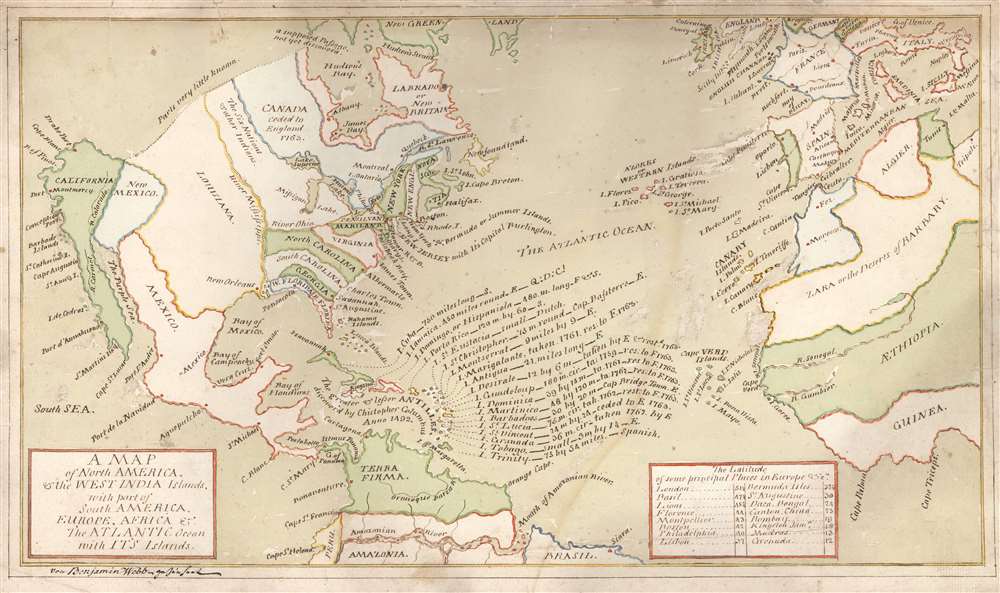
The map is centered on the Atlantic Ocean, embracing North America all the way to the Pacific, and reaching as far east as Italy. Part of Western Africa is shown. The northern part of the map reaches Greenland, while the Amazon River is included in the south. California is not shown as an island, but the shape of its coastline is from the transitional period in which the insular California was considered an error, but also in which the Pacific Northwest was little understood: Webb labels the northwest 'Parts Very Little Known' but also marks a speculative Northwest Passage leading out of Hudson's Bay. The West Indies are labeled in flowing, attractive script. A table near the lower right giving 'the Latitude of some principal Places in Europe etc.' lists London, Basil (sic), Lions, Florence, Montpellier and Lisbon are accompanied by Boston, Philadelphia, Bermuda, Kingston, and Canton - perhaps leaning more on 'etc.' than 'Europe.'A German and English Map
Webb was a German (or possibly Swiss) emigre, living and working in London both as a schoolmaster and accountant. He has signed this map 'von Benjamin Webb gezeichnet' (that is, drawn by Benjamin Webb), a German signature which would appear odd in a map executed uniformly in English were the map not rooted in German scholarship in other ways. Webb's map uses the name 'The Purple Sea' for the Gulf of California, variants of which we have only seen in a handful of maps by Leonard Euler (1707 - 1783), Tobias Conrad Lotter (1717 - 1777) and Johann Baptiste Homann (1664 - 1724) - all German mapmakers. Also, variants to the toponymy of the Baja Peninsula, for example 'Port d' Annabueno / Annobueno' appear to be unique to the German mapmakers. On the Guinea coast of Africa, another term apparently unique to German maps of this period, 'Triceps' for the Cape of 3 Points, - appears on Webb's map as well. Webb's rendering of the Amazon River suggests either Homann or Lotter, as it does not resemble that used by Euler.We know nothing of Webb's youth: there are references in the historical record to a 'a hamburger merchant' in London named Benjamin Webb, and the earliest surviving correspondence of Webb with Franklin is a letter of reference on behalf of an old associate from Leipzig, so it appears that he was born and educated in Germany to later arrive in England. It is also possible that he was from Switzerland: When misfortune struck later in life, it was to Basel that he fled to avoid his creditors. The map is also suggestive in that, whereas no German cities are named, the Swiss cities of Bern, Geneva, and Basil (Basel) appears both on the map and in the map's latitude tables. Regardless of which German-speaking city Webb came from, his presence in 1760s London was not odd. England's Kings in the eighteenth century were Hanoverian, and culturally German; Britain's allies in the Seven Years' War were Prussian and Hanoverian themselves. There were many German emigres living in England in positions of prominence and it is unsurprising to see a university-educated German severing as schoolmaster. However Webb arrived in London, by the time he produced this map he seems to have identified as British: he has expressed in this map a very British sense of triumph, there being no question here that the author celebrates the English defeat of France. Webb notes islands that had been captured by England but then returned by treaty; and the new borders evidenced on this map due to the Treaty of Paris were by all accounts favorable to Britain.
The End of the Seven Years' War
Political boundaries could have come from a great many contemporary sources, very possibly a map based on the Mitchell, or one of Thomas Kitchin's maps of North America and the Caribbean: in the aftermath of the 1763 Treaty of Paris there were a number of maps produced to illustrate the new borders. Upon Webb's German-sourced framework, he places the new borders and illustrates the new status quo in the West Indies. North America east of the Mississippi shows, in simplified form, the British colonies as they stood after the Treaty. Florida is divided into in its two parts, for instance. New Jersey is noted prominently beyond its actual size, 'NEW JERSEY with Its Capital Burlington.' (The grandiose notation of the province's 1763 - 1783 Capital may simply be due to the inability of Webb to include it legibly on the crowded map.)Q.D.C.? - Quam Deus Conservet
Each of the Caribbean islands named has a notation of its size, as well as its political disposition after the Treaty. (For example, 'I. Trinity - 75 by 54 miles - Spanish.') Among these, Jamaica stands apart. Not only in size (it appears on the map here nearly as large as Hispaniola) but it also for the unique note: 'I. Jamaica. 450 miles round. E. - Q:D:C!' 'Q.D.C.' is an abbreviation for the Latin phrase, 'Quam Deus Conservet' translating to 'Which God May Preserve' or perhaps, 'May God Preserve it.' In the 18th century, this note would often appear in, or on, letters as a prayer for safe arrival of the letter, and the safe passage of the ship carrying it. The connection of this phrase to Jamaica seems twofold: first, a disproportionate number of letters sent to and from Jamaica would bear the salutation, since all of them involved a perilous sea voyage. Second (especially given the exclamation mark in the note) Q.D.C.! implies that Webb may have had ties to or interests specifically in Jamaica, considering it particularly deserving of divine protection. During the Seven Years' War, Jamaica had been embroiled in Tacky’s Revolt (1761), during which more than a thousand slaves took the opportunity of the war's disruption to fight for their freedom. So desperate were the British to maintain control over the slave population that they armed Black soldiers to bring the rebellion under control. Certainly, Londoners would have been inclined to be triumphal at the conclusion of the Seven Years' War - after all, North America became substantially more English - but this call for the preservation of Jamaica suggests a more personal connection than we are able, ultimately, to substantiate. Certainly, such devotion to so important a British colony indicates that Webb, whatever his birthplace, was identifying strongly with British interests.Webb and Benjamin Franklin
As obscure as his history is, Webb surfaces in later life as a correspondent with none other than Benjamin Franklin, providing a Leipzig scholar with a letter of introduction to the famous man. In 1784, having fallen upon hard times, Webb received a loan from Franklin in one of the earliest and most famous documented instances of the 'Pay It Forward' concept.Publication History and Census
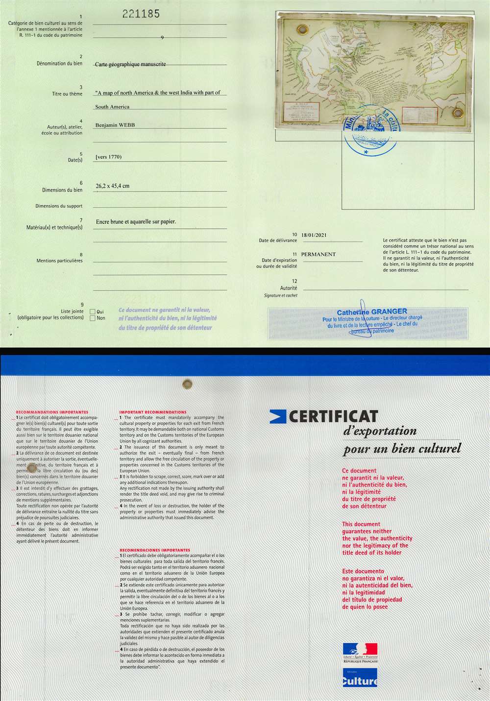
This map is a manuscript and therefore unique. No other examples. The map is accompanied by an official 'Certificat d'Exportation' from the government of France.Cartographer
Benjamin Webb (fl. 1760 - 1784) was a merchant and sometime schoolmaster active in London, England and later Basel, Switzerland in the mid to late 18th century. His origins are obscure: there is a reference to 'A Hamburger Merchant' by the name, and his associations suggest that he may have been at university in Leipzig. But his adult life found him London, where he began a decades-long correspondence with the American inventor and statesman Benjamin Franklin (1706 - 1790). He is famously the recipient of Franklin's generosity in what is the earliest documented instance of the concept of 'Paying It Forward.' The name 'Benjamin Webb' is common enough that it is difficult to develop a specific history. We know from his letters to Franklin that he was involved in business with his father-in-law, William Curties at Martin's-Lane, Cannon-Street, London. This Curties-Webb enterprise dates to at least 1767, when 'Mess. Webb and Curties' are listed as subscribers to 'Benjamin Webb's' essay on accounting and negotiation. It is unclear if the author of that work is the same as 'Webb and Curties' but it is likely the case. If so, then Webb self-describes as a 'writing-Master and accountant' and 'Master of the Free Grammar School in Bunhill Row'. Webb and Curties went into insolvency in 1777 or 1778. Webb's earliest surviving correspondence with Franklin dates to this period, penned on December 25, 1777. Therein, Webb, writing from London, sent Franklin, then in Paris, a letter of recommendation on behalf of a long-standing scholar friend, the Lexicographer Johann Rogle (1728 - 1791) of the University of Leipzig. The content suggests significant earlier communication and engagement between Franklin and Webb - most of which is now lost. Likely his relationship with Franklin dates to the period from 1757 to 1762, when Franklin was in England protesting the influence of the Penn family on the governance of Pennsylvania. In 1781, Webb's wife, Mary Curties, long in poor health, died. Following his wife's death, Webb fled from his creditors to settle in Basel, Switzerland, possibly with his son, Charles Webb. There they became close with Benjamin Franklin Bache (1769 - 1798), Franklin's grandson, with whom Charles was close in age. (Franklin had sent his grandson to Geneva in 1779 to gain first-hand experience in a Republic.) Webb's bankruptcy and flight to Switzerland led to a 1784 letter begging assistance of Franklin on the strength of their relationship and his friendship with Bache. Franklin's response in a famous letter was a loan of 10 Louis d'or (French gold coins), and instructions that 'when you meet with another honest Man in similar Distress, you must pay me by lending this Sum to him; enjoining him to discharge the Debt by a like operation when he shall be able... This is a Trick of mine for doing a deal of good with a little money.' Although it is implied in the letter that Franklin's 'Pay It Forward' concept pre-dated his employment of it with Webb, it is in this correspondence that it appears for the first time. More by this mapmaker...


