Digital Image: 1749 Henry Ellis Map of Efforts to Discover a Northwest Passage
NorthwestPassage-ellis-1750_d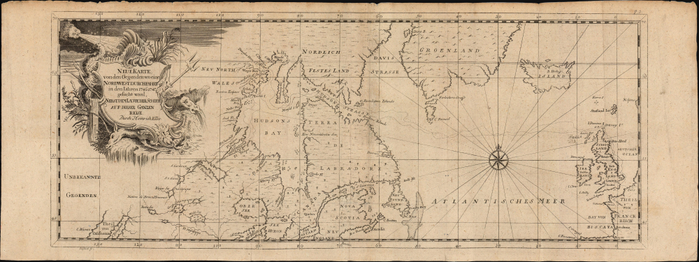

Title
Neue Karte von den Gegenden wo eine Nordwest Durchfahrt in den Iahren 1746-1747...
1750 (undated) 6.75 x 17.25 in (17.145 x 43.815 cm) 1 : 2300000
1750 (undated) 6.75 x 17.25 in (17.145 x 43.815 cm) 1 : 2300000
Description
FOR THE ORIGINAL ANTIQUE MAP, WITH HISTORICAL ANALYSIS, CLICK HERE.
Digital Map Information
Geographicus maintains an archive of high-resolution rare map scans. We scan our maps at 300 DPI or higher, with newer images being 600 DPI, (either TIFF or JPEG, depending on when the scan was done) which is most cases in suitable for enlargement and printing.
Delivery
Once you purchase our digital scan service, you will receive a download link via email - usually within seconds. Digital orders are delivered as ZIP files, an industry standard file compression protocol that any computer should be able to unpack. Some of our files are very large, and can take some time to download. Most files are saved into your computer's 'Downloads' folder. All delivery is electronic. No physical product is shipped.
Credit and Scope of Use
You can use your digial image any way you want! Our digital images are unrestricted by copyright and can be used, modified, and published freely. The textual description that accompanies the original antique map is not included in the sale of digital images and remains protected by copyright. That said, we put significant care and effort into scanning and editing these maps, and we’d appreciate a credit when possible. Should you wish to credit us, please use the following credit line:
Courtesy of Geographicus Rare Antique Maps (https://www.geographicus.com).
How Large Can I Print?
In general, at 300 DPI, you should at least be able to double the size of the actual image, more so with our 600 DPI images. So, if the original was 10 x 12 inches, you can print at 20 x 24 inches, without quality loss. If your display requirements can accommodate some loss in image quality, you can make it even larger. That being said, no quality of scan will allow you to blow up at 10 x 12 inch map to wall size without significant quality loss. For more information, it is best consult a printer or reprographics specialist.
Refunds
If the high resolution image you ordered is unavailable, we will fully refund your purchase. Otherwise, digital images scans are a service, not a tangible product, and cannot be returned or refunded once the download link is used.
Cartographer S
Henry Ellis (August 29, 1721 - January 21, 1806) was an Irish explorer, author, slave trader and governor of the colonies of Georgia and Nova Scotia. He was educated in the law, but in 1746 he would subscribe to, and work for a company, led by Arthur Dobbs, dedicated to the discovery of the Northwest Passage. Ellis served as agent for the company on the voyages it funded between 1746 and 1748, which failed to identify a viable connection between Hudson's Bay and the Pacific. Nevertheless, Ellis' impassioned arguments for the existence of a Northwest Passage - and his published accounts of the failed efforts to find one - would see him inducted into the Royal Society. Doubtless seeking a more reliable source of income, Ellis between 1750 and 1755 became a slave trader, taking active part in the purchase of Africans for sale to buyers in Jamaica. Perhaps his success in the trade led Lord Halifax, President of the Board of Trade, to name Ellis lieutenant governor of Georgia in 1756. He would become royal governor there in 1758, where he would be notable for negotiating a treaty with the Creeks in order to secure the colony's border. Georgia's climate appears to have made an impression on him: his contribution to the 1758 transactions of the Royal Society was an article entitled 'Heat of the Weather in Georgia' and by 1760 he would have to resign his post due to the impact of the heat on his health. Between 1761 and 1763 he was commissioned governor of Nova Scotia, the duties of which position he did not appear to execute. He would later retire to scientific researches in Italy, where he would die in 1806. More by this mapmaker...
Johann Christian Püschel (1718 - 1771) was a German engraver active in Leipzig, whose works ranged from maps to portraits to vignette illustrations. Nothinng is known of him beyond his work, Learn More...
References
Not in OCLC; not in Kershaw.