1640 Blaeu Map of the Maghreb or Barbary Coast, Northern Africa
NovaBarbariae-blaeu-1640$800.00

Title
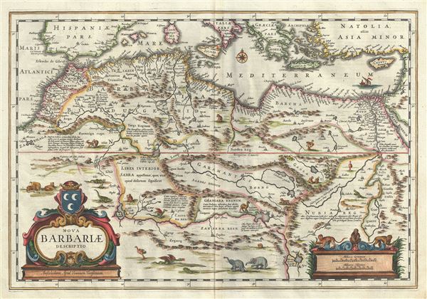
Nova Barbariae Descriptio.
1640 (undated) 15 x 21.5 in (38.1 x 54.61 cm) 1 : 8250000
1640 (undated) 15 x 21.5 in (38.1 x 54.61 cm) 1 : 8250000
Description
This is a fascinating example of Johannes Bleau's decorative c.1640 map of the Maghreb or Barbary Coast of northern Africa. It covers from the Morocco to the Nile Delta. The region consists of the modern day nations of Tunisia, Libya, Algeria, Egypt and Morocco. The map offers excellent detail throughout showing mountains, rivers, national boundaries, cities, regions, and tribes.
As Bonne was preparing this map, the Barbary Coast was a hotbed of piracy - much like the Somali coast today. The Barbary Pirates would attack trading ships passing through the narrow Gibraltar straits and western Mediterranean. Ships would be destroyed or appropriated, cargo sized, and the crews and passengers enslaved. By the early 19th century, piracy in this region would become so intense that the United States would launch its first major naval offensive against Tripoli. The resultant 1805 Battle of Derne would later inspire a portion of the lyrics of the Marines' Hymn, 'the shores of Tripoli.'
In addition to Bleau's fascinating depiction of the region, among the most in any mapping of this region during the time, there are also a number of attractive decorative elements. The land is filled with several animals throughout, including elephants, ostriches, antelopes, monkeys, crocodiles, prehistoric fire breathing dragons, etc., while a ship sails in the Mediterranean near Cyprus and the mouth of the River Nile. A decorative baroque title cartouche appears at the lower left quadrant and in the lower right quadrant, another smaller cartouche frames the distance scales, surrounded by three monkeys.
Cartographer
Joan (Johannes) Blaeu (September 23, 1596 - December 21, 1673) was a Dutch cartographer active in the 17th century. Joan was the son of Willem Janszoon Blaeu, founder of the Blaeu firm. Like his father Willem, Johannes was born in Alkmaar, North Holland. He studied Law, attaining a doctorate, before moving to Amsterdam to join the family mapmaking business. In 1633, Willem arranged for Johannes to take over Hessel Gerritsz's position as the official chartmaker of the Dutch East India Company, although little is known of his work for that organization, which was by contract and oath secretive. What is known is his work supplying the fabulously wealthy VOC with charts was exceedingly profitable. Where other cartographers often fell into financial ruin, the Blaeu firm thrived. It was most likely those profits that allowed the firm to publish the Theatrum Orbis Terrarum, sive, Atlas Novus, their most significant and best-known publication. When Willem Blaeu died in 1638, Johannes, along with his brother Cornelius Blaeu (1616 - 1648) took over the management of the Blaeu firm. In 1662, Joan and Cornelius produced a vastly expanded and updated work, the Atlas Maior, whose handful of editions ranged from 9 to an astonishing 12 volumes. Under the brothers' capable management, the firm continued to prosper until the 1672 Great Amsterdam Fire destroyed their offices and most of their printing plates. Johannes Blaeu, witnessing the destruction of his life's work, died in despondence the following year. He is buried in the Dutch Reformist cemetery of Westerkerk. Johannes Blaeu was survived by his son, also Johannes but commonly called Joan II, who inherited the family's VOC contract, for whom he compiled maps until 1712. More by this mapmaker...
Condition
Very good. Original platemark visible. Minor wear along original centerfold. Minor foxing.