Digital Image: 1941 Pictorial Map of the Old York Road, Eastern Pennsylvania
OldYorkRoad-kohlbrenner-1941_d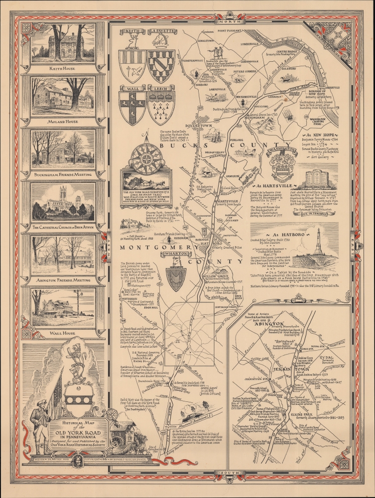

Title
Historical Map of the Old York Road in Pennsylvania.
1941 (dated) 28 x 21 in (71.12 x 53.34 cm) 1 : 100000
1941 (dated) 28 x 21 in (71.12 x 53.34 cm) 1 : 100000
Description
FOR THE ORIGINAL ANTIQUE MAP, WITH HISTORICAL ANALYSIS, CLICK HERE.
Digital Map Information
Geographicus maintains an archive of high-resolution rare map scans. We scan our maps at 300 DPI or higher, with newer images being 600 DPI, (either TIFF or JPEG, depending on when the scan was done) which is most cases in suitable for enlargement and printing.
Delivery
Once you purchase our digital scan service, you will receive a download link via email - usually within seconds. Digital orders are delivered as ZIP files, an industry standard file compression protocol that any computer should be able to unpack. Some of our files are very large, and can take some time to download. Most files are saved into your computer's 'Downloads' folder. All delivery is electronic. No physical product is shipped.
Credit and Scope of Use
You can use your digial image any way you want! Our digital images are unrestricted by copyright and can be used, modified, and published freely. The textual description that accompanies the original antique map is not included in the sale of digital images and remains protected by copyright. That said, we put significant care and effort into scanning and editing these maps, and we’d appreciate a credit when possible. Should you wish to credit us, please use the following credit line:
Courtesy of Geographicus Rare Antique Maps (https://www.geographicus.com).
How Large Can I Print?
In general, at 300 DPI, you should at least be able to double the size of the actual image, more so with our 600 DPI images. So, if the original was 10 x 12 inches, you can print at 20 x 24 inches, without quality loss. If your display requirements can accommodate some loss in image quality, you can make it even larger. That being said, no quality of scan will allow you to blow up at 10 x 12 inch map to wall size without significant quality loss. For more information, it is best consult a printer or reprographics specialist.
Refunds
If the high resolution image you ordered is unavailable, we will fully refund your purchase. Otherwise, digital images scans are a service, not a tangible product, and cannot be returned or refunded once the download link is used.
Cartographer
Howard Kohlbrenner (November 28, 1897 - February 8, 1986) was a Philadelphia-based artist and art director for several publications. He attended the Philadelphia Museum College of Art and Pennsylvania Academy of Fine Arts. After working as an accountant in his early 20s, presumably while also practicing his own artistic works, from 1929 until the early 1970s, Kohlbrenner served as the At Director for the Chilton Company's Automotive Publications, including Automotive Industries and Motor Age. He took on a similar role with other publications by McGraw-Hill (which seems to have bought out Chilton) as well, such as Food Engineering and Aircraft and Missiles. Kohlbrenner was also deeply involved with the Old York Road Historical Society, designing the organization's logo in 1936 and serving for a time as an editor of the Old York Road Historical Society Bulletin. More by this mapmaker...
References
OCLC 854856692.