
This item below is out of stock, but another example (left) is available. To view the available item, click "Details."
Details
1842 Greenleaf Map of Oregon Territory and British Columbia
1842 (undated) $950.00
1849 Greenleaf Map of Oregon Territory and British Columbia
OregonTerritory-greenleaf-1849$475.00

Title
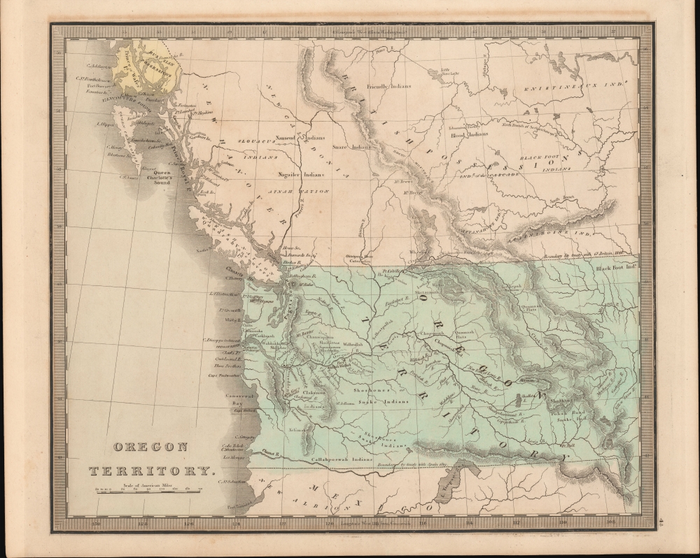
Oregon Territory.
1849 (undated) 11 x 13 in (27.94 x 33.02 cm) 1 : 7200000
1849 (undated) 11 x 13 in (27.94 x 33.02 cm) 1 : 7200000
Description
This is Jeremiah Greenleaf's 1849 map of Oregon Territory. The map reflects the resolution of the Oregon Question, with a fixed boundary at the 49th parallel. It is one of the few atlas maps of Oregon Territory to appear prior to 1850.
A Closer Look
Coverage embraces from Prince of Wales Island to Port Trinidad and inland as far as modern-day Idaho. The area covered roughly corresponds with modern day Oregon, Washington, British Columbia, and Idaho. It recognizes Russian claims in Alaska as far south as Portland Inlet, the current Alaska-Canada border. The area of focus is Oregon, at the time dominated by Native Americans, with only a few Anglo-European settlements competing for the region's rich fur trade. Among these are Astoria (Ft. George), Fort Wallah Wallah, Fort Hall, Fort Vancouver, McKay's Settlement, and Jarvis' Settlement. River courses, particularly the Columbia River (also named the Oregon River), which acted as the primary artery of travel eastward, and well defined. Great Salt Lake, appearing in the bottom right, is here named Lake Timpanoges.54-40 or Fight! American Claims to British Columbia
Following the transcontinental crossing of North America by the British Northwest Company sponsored explorer Alexander MacKenzie (1792 – 1793), and the American expedition of Lewis and Clark up the Missouri to the mouth of the Columbia River (1804 – 1806), it became apparent that control of the fur and resource rich Pacific Northwest would bring great wealth and power to whoever could assert sovereignty. The American tycoon John Jacob Astor, with the permission of President Thomas Jefferson, was the first to attempt a permanent trading colony in the region, founding Astoria on the Columbia River in 1811. This quickly led to a confrontation with the established British-Canadian Northwest Company over this valuable territory. Americans in the 1820s through the 1840s argued that most of the Pacific Northwest should be part of the United States as a legacy of the 1803 Louisiana Purchase. England, on the other hand, argued for residual claims to the region derived from the MacKenzie Expedition and its fur trading empires: The Northwest Company and the Hudson Bay Company. The Oregon Dispute, as it came to be known, became an important geopolitical issue between the British Empire and the United States, especially after the War of 1812. Americans adopted the slogan '54-40 or Fight!' until the Oregon Question was finally resolved roughly along the current border by the 1846 Oregon Treaty.Publication History and Census
This map is a much-updated revision of the David Hugh Burr map of 1833. The Burr map plates eventually fell into the hands of Jeremiah Greenleaf, who revised them for publication in his own Universal Atlas. The present example is from the 1849 edition of the atlas, the last and final, which nonetheless was extensively revised over the 1848. We note an example in the David Rumsey collection, which has been populated digitally throughout OCLC, making a comprehensive survey of existing physical examples nearly impossible. Nonetheless, the 1849 edition of the atlas is rare, with Rumsey correctly noted that it is not in Karpinski. We do note an example, however, in Phillips.CartographerS
Jeremiah Greenleaf (1791 - 1864) is a little known but highly admired American cartographer of the early 19th century. He published from roughly 1830 to 1850. His most important work is A New Universal Atlas; Comprising of all the Principal Empires, Kingdoms, and States Throughout the World and Forming a distinct Atlas of the United States, published in several editions in the 1840s. Many of his maps are reformatted versions of his contemporary David Burr's much admired cartographic works. Greenleaf's maps are extremely rare and admired for their stunningly vivid pastel color washes. More by this mapmaker...
David Hugh Burr (August 18, 1803 - December 25, 1875) of one of the first and most important truly American cartographers and map publishers. Burr was born in Bridgeport Connecticut in August of 1803. In 1822 Burr moved to Kingsboro, New York to study law. A year and a half later he was admitted to the New York Bar association. Burr must have questioned his choice of careers because shortly after being admitted to the Bar, he joined the New York State Militia. Though largely untrained in the art of surveying, Burr was assigned to work under Surveyor General of New York, Simeon De Witt, to survey several New York Roadways. Seeing a window of opportunity, Burr was able to negotiate with the governor of New York at the time, De Witt Clinton, to obtain copies of other New York survey work in order to compile a map and Atlas of the state of New York. Recognizing the need for quality survey work of its territory, the government of New York heartily endorsed and financed Burr's efforts. The resulting 1829 Atlas of the State of New York was the second atlas of an individual U.S. state and one of the most important state atlases ever produced. Burr went on to issue other maps both of New York and of the United States in general. In cooperation with publishing firm of Illman & Pillbrow, he produced an important New Universal Atlas and, with J.H. Colton, several very important maps of New York City. In recognition of this work, Burr was appointed both "Topographer to the Post office" and "Geographer to the House of Representatives of the United States". Later, in 1855, Burr was assigned to the newly created position of Surveyor General to the State of Utah. Burr retired from the position and from cartographic work in general in 1857 when light of some of his financial misdeeds and frauds came to light. He was accused of submitting false expense reports and underpaying employees, among other indiscretions. Learn More...
Source
Greenleaf, J., New Universal Atlas, (Brattleboro, Vermont: Greenleaf) 1842.
Condition
Very good. Some offsetting.
References
Rumsey 15176.000. OCLC 727083903.