This item has been sold, but you can get on the Waitlist to be notified if another example becomes available, or purchase a digital scan.
1826 Weiland Map of European Turkey, Greece and the Balkans
OsmanischeEuropa-weiland-1826$137.50

Title
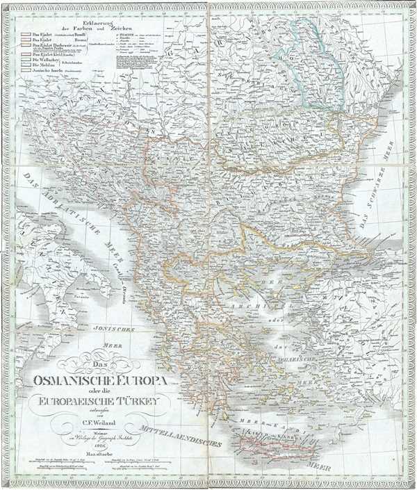
Das Osmanische Europa oder die Europaeische Turkey.
1826 (dated) 22 x 19 in (55.88 x 48.26 cm) 1 : 35000000
1826 (dated) 22 x 19 in (55.88 x 48.26 cm) 1 : 35000000
Description
This is a scarce separate-issue 1826 map of European Turkey by C. F. Weiland. It covers Greece and the Balkans from Romania to Crete and includes the modern day nations of Greece, Macedonia, Albania, Croatia, Bosnia, Serbia, Bulgaria and Moldova. It depicts the European lands claimed by the Ottoman Empire in the early 19th century. Various important cities, rivers, lakes, islands, mountains and other topographic features.
As this map was being drawn, the Greek people were in the midst of a bloody war for independence against their Ottoman Turkish overlords. With the help their European allies in Russia, United Kingdom, and France, the Greek revolutionaries finally threw off the Ottoman yolk in 1832.
This map was created by C. F. Weiland and published by the Weimar Geographical Institute.
CartographerS
Carl Ferdinand Weiland (1782 - 1847) was a German cartographer active with the Weimar Geographisches Institut, where he headed up map and globe production, in early and middle part of the 19th century. Weiland was a trained as a military cartographer who, with his career at the Geographisches Institut, move into the private market. Among his other work, Weiland issued a German edition of Carey and Lea's American Atlas. Their edition, which was fully re-engraved in Germany, is of superior workmanship and stands out as some of the finest 19th century maps of individual U.S. states printed outside of America.Carl Ferdinand Weiland (1782 - 1847) was a German cartographer active with the Weimar Geographisches Institut, where he headed up map and globe production, in early and middle part of the 19th century. Weiland was a trained as a military cartographer who, with his career at the Geographisches Institut, move into the private market. Among his other work, Weiland issued a German edition of Carey and Lea's American Atlas. Their edition, which was fully re-engraved in Germany, is of superior workmanship and stands out as some of the finest 19th century maps of individual U.S. states printed outside of America. More by this mapmaker...
Geographisches Institut, Weimar (fl. 1804 - c. 1903) was a German map and globe publishing house and geographical research institute based in Weimar. The organization primarily focused on republishing and improving upon the works of earlier cartographers, including Kitchin, Jefferys, Carey, and others. In general, its publications are known for their fine engraving, attention to detail, historical accuracy, and overall high quality. The firm was founded in 1804 by Friedrich Justin Bertuch (???? - c. 1845) and, on his death, passed to his son Robert Froreip (???? - 1855), then to Louis Denicks of Luneberg, then in 1859 to Voigt & Günther, in 1883 to F. Arnd, from 1890 - 1893 to Julius Kettler, and in 1903 to Max Wedekind. During the institute's height in the early 19th century, most of its cartographic publication was overseen by Carl Ferdinand Weiland (1782 - 1847). The firm also employed the cartographers Franz Xaver von Zach, Adam Christian Gaspari, Heinrich Kiepert, Karl (or Carl) and Adolf Graef, Julius Kettler, Carl Riemer and Karl Christian Bruhns. Weimar was a logical place for a collective like the Geographisches Institut to arise; it was a cultural mecca in the German-speaking world in the late 18th and 19th centuries because of its liberal atmosphere and associations with figures like Schiller, Herder, and, above all, Goethe, who spent most of his adult life in the city. Learn More...
Condition
Very good. Dissected and backed on linen. Minor spotting. Minor wear along fold lines.
References
OCLC: 80976968.