Digital Image: 1933 Rothe and Gibbs Pictorial Map of Europe / WWI Route of 301st Artillery
OverThereAndBack-rothegibbs-1933_d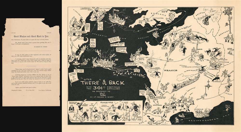

Title
Over There' and Back with the 301st First Field Artillery.
1933 (undated) 13.5 x 19 in (34.29 x 48.26 cm)
1933 (undated) 13.5 x 19 in (34.29 x 48.26 cm)
Description
FOR THE ORIGINAL ANTIQUE MAP, WITH HISTORICAL ANALYSIS, CLICK HERE.
Digital Map Information
Geographicus maintains an archive of high-resolution rare map scans. We scan our maps at 300 DPI or higher, with newer images being 600 DPI, (either TIFF or JPEG, depending on when the scan was done) which is most cases in suitable for enlargement and printing.
Delivery
Once you purchase our digital scan service, you will receive a download link via email - usually within seconds. Digital orders are delivered as ZIP files, an industry standard file compression protocol that any computer should be able to unpack. Some of our files are very large, and can take some time to download. Most files are saved into your computer's 'Downloads' folder. All delivery is electronic. No physical product is shipped.
Credit and Scope of Use
You can use your digial image any way you want! Our digital images are unrestricted by copyright and can be used, modified, and published freely. The textual description that accompanies the original antique map is not included in the sale of digital images and remains protected by copyright. That said, we put significant care and effort into scanning and editing these maps, and we’d appreciate a credit when possible. Should you wish to credit us, please use the following credit line:
Courtesy of Geographicus Rare Antique Maps (https://www.geographicus.com).
How Large Can I Print?
In general, at 300 DPI, you should at least be able to double the size of the actual image, more so with our 600 DPI images. So, if the original was 10 x 12 inches, you can print at 20 x 24 inches, without quality loss. If your display requirements can accommodate some loss in image quality, you can make it even larger. That being said, no quality of scan will allow you to blow up at 10 x 12 inch map to wall size without significant quality loss. For more information, it is best consult a printer or reprographics specialist.
Refunds
If the high resolution image you ordered is unavailable, we will fully refund your purchase. Otherwise, digital images scans are a service, not a tangible product, and cannot be returned or refunded once the download link is used.
Cartographer S
Lewis Rothe (July 6, 1874 - November 28, 1951) was an American artist, illustrator, and painter. Born in Massachusetts, Roth spent most of his adult life in California, residing in San Francisco, San Diego, and Oakland. He married Enid Miller in 1939, with whom he had a son and a daughter and was a stepfather to Enid's two children from a previous marriage. More by this mapmaker...
Warren Rockwood Gibbs (June 17, 1878 - May 3, 1941) was an American manufacturer and farmer. Born in Burlington, Vermont, Gibbs attended Cornell University and graduated in 1900. He served with the Supply Company of the 301st Field Artillery during World War I. After the war, Gibbs returned to Richmond, Massachusetts, where he and his wife rand Rock Ridge Farm for an unknown number of years moving to California, where he died at Berkeley. He married his wife Rebecca McClure Whitehead on October 18, 1906 in Pittsfield, Massachusetts, whom he may have divorced, as it appears he was married to Irene Gibbs in 1940, and Rebecca's death is recorded as June 13, 1947 in Richmond, Massachusetts. Learn More...
References
OCLC 773039257.