Digital Image: 1919 / 1927 Moore Plan of Pacific Grove, California
PacificGrove-moore-1919_d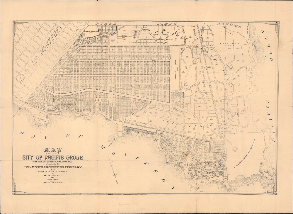

Title
Map of the City of Pacific Grove Monterey County California compiled for the Del Monte Properties Company.
1919 (dated) 13.25 x 20.25 in (33.655 x 51.435 cm) 1 : 7800
1919 (dated) 13.25 x 20.25 in (33.655 x 51.435 cm) 1 : 7800
Description
FOR THE ORIGINAL ANTIQUE MAP, WITH HISTORICAL ANALYSIS, CLICK HERE.
Digital Map Information
Geographicus maintains an archive of high-resolution rare map scans. We scan our maps at 300 DPI or higher, with newer images being 600 DPI, (either TIFF or JPEG, depending on when the scan was done) which is most cases in suitable for enlargement and printing.
Delivery
Once you purchase our digital scan service, you will receive a download link via email - usually within seconds. Digital orders are delivered as ZIP files, an industry standard file compression protocol that any computer should be able to unpack. Some of our files are very large, and can take some time to download. Most files are saved into your computer's 'Downloads' folder. All delivery is electronic. No physical product is shipped.
Credit and Scope of Use
You can use your digial image any way you want! Our digital images are unrestricted by copyright and can be used, modified, and published freely. The textual description that accompanies the original antique map is not included in the sale of digital images and remains protected by copyright. That said, we put significant care and effort into scanning and editing these maps, and we’d appreciate a credit when possible. Should you wish to credit us, please use the following credit line:
Courtesy of Geographicus Rare Antique Maps (https://www.geographicus.com).
How Large Can I Print?
In general, at 300 DPI, you should at least be able to double the size of the actual image, more so with our 600 DPI images. So, if the original was 10 x 12 inches, you can print at 20 x 24 inches, without quality loss. If your display requirements can accommodate some loss in image quality, you can make it even larger. That being said, no quality of scan will allow you to blow up at 10 x 12 inch map to wall size without significant quality loss. For more information, it is best consult a printer or reprographics specialist.
Refunds
If the high resolution image you ordered is unavailable, we will fully refund your purchase. Otherwise, digital images scans are a service, not a tangible product, and cannot be returned or refunded once the download link is used.
Cartographer
William T. Moore (February 6, 1884 - April 19, 1977) was a California surveyor and civil engineer. Moore was born in Cherry Hill, Maryland. He relocated to California sometime before 1910. In 1911, he married Mable Noble in Monterey, California. He worked for many years with the Del Monte Properties Co. In a 1937 city directory of Pacific Grove, California, he is noted as the 'chief engineer' of the Del Monte Properties, the developer responsible for building Pebble Beach (the company was reincorporated as the Pebble Beach Corporation in 1977, later renamed the Pebble Beach Company). In 1952, Moore was made a Vice President of Del Monte Properties and Head of the Engineering Department. Based on newspaper reports of the local Pacific Grove Tribune and other local newspapers, Moore was deeply involved in the local community through the Masonic Lodge, school district, Chamber of Commerce, and the Monterey County Planning Commission. More by this mapmaker...
References
OCLC 123082111 (possible variant printing).