1739 Homann Heirs / Delagrive Map of Paris and Environs
Pairs-homanheirs-1739$1,100.00

Title
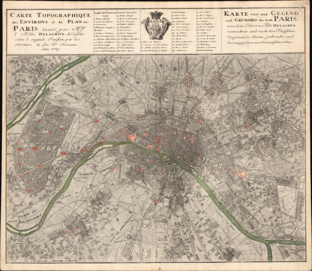
Carte Topographique des Environs et du Plan de Paris leveé par Msr. l'Abbé Delagrive, et Copiée selon l'original Parisien par les Heritiers de fus Dr. Homann Anno 1739. / Karte von der Gegend und Grundris der Stadt Paris, von dem Herrn Abt Delagrive verzeichnet und nach dem Parisischen Original ins kleine gebracht und her ausgegeben von Homoenischen Erben.
1739 (dated) 20 x 24 in (50.8 x 60.96 cm) 1 : 247000
1739 (dated) 20 x 24 in (50.8 x 60.96 cm) 1 : 247000
Description
This is the scarce 1739 Homann Heirs edition of the seminal Jean Delagrive map of Paris, France, and its environs. It illustrates Paris under the reign of King Louis XV, at its peak as a center of Enlightenment thought, with Parisian intellectuals, philosophers, and artists shaping the cultural and political discourse of Europe.
A Closer Look
Centered on Île de la Cité, coverage embraces what is today greater Paris, extending from the Bois de Boulogne and the Bois de Vincennes and from Clichy (Clichy) to Gentil. The Seine winds laterally through the center of the map. Within Paris, streets are illustrated, if not named, and a numerical system, corresponding to a table at top center, names 63 significant locations.Sources
The map is sourced from the 1730 central sheet of Delagrive's 9-section map of Paris and environs, Environs de Paris, leves geometriquement (Rumsey 10255.000), a landmark production measuring 178 x 252 cm, considered the definitive map of the environs of Paris of its age (first published as a full set of 9 sheets in 1740). This great map is comparable in significance and size to the epic 1739 Turgot/Bretez map of Paris, on which Delagrive collaborated as Official Geographer. The central sheet for Delagrive's great map was published in 1730, a full 10 years before the remaining 8 sheets were engraved and published.Publication History and Census
This map was designed by Jean Delagrive in 1730 and published by Homan Heirs in 1739. Like many Homann maps, this was a separate issue and not included in any standard atlas; instead, it was sold separately and included in some deluxe and composite atlases. It is thus rare to the market if well represented institutionally.CartographerS
Homann Heirs (1730 - 1848) were a map publishing house based in Nuremberg, Germany, in the middle to late 18th century. After the great mapmaker Johann Baptist Homann's (1664 - 1724) death, management of the firm passed to his son Johann Christoph Homann (1703 - 1730). J. C. Homann, perhaps realizing that he would not long survive his father, stipulated in his will that the company would be inherited by his two head managers, Johann Georg Ebersberger (1695 - 1760) and Johann Michael Franz (1700 - 1761), and that it would publish only under the name 'Homann Heirs'. This designation, in various forms (Homannsche Heirs, Heritiers de Homann, Lat Homannianos Herod, Homannschen Erben, etc..) appears on maps from about 1731 onwards. The firm continued to publish maps in ever diminishing quantities until the death of its last owner, Christoph Franz Fembo (1781 - 1848). More by this mapmaker...
Jean Delagrive (1689 - April 18, 1757), a.k.a 'de La Grive', was a French Lazarist priest, geographer, engraver, and geometrist active in Paris in the first half of the 18th century. Delagrive was born in Sedan, Ardennes, France. After initial studies in the Ardennes, he came to Paris and entered the congregation of the Mission or congregation of the priests of Saint-Lazare. In 1713, after being ordained, he was sent to Krakow, Poland, to teach theology. He returned to Paris in 1714 and thenceforth dedicated himself to the study of geometry and cartography. His first plan of Paris was produced in 1718, but being a perfectionist, he was unsatisfied with the product and destroyed the plates. He published a second map of Paris in 1728, which earned him the post of official geographer of the city of Paris. The plan was definitive for its geometrical precision and accuracy. He continued to publish works on Paris, its environs, Versailles, and the course of the Seine until about 1745. In 1733, he assisted César-François Cassini in measuring of the meridian of the Paris Observatory. It is also one of his maps that first presents the name Champs-Élysées. Within the order of Saint-Lazare, he attained the status of Abbot and is often referred to as Abbé Delagrive. Delagrive died in 1757. Learn More...
Condition
Very good.
References
OCLC 1224520568. c.f. Rumsey 10255.000. Vallee, Leon, Catalogue des plans de Paris et des cartes de l'ile de France, (Bibliotheque Nacionale), #841.