This item has been sold, but you can get on the Waitlist to be notified if another example becomes available, or purchase a digital scan.
1603 Ortelius Map of the Holy Land
PalestinaeSive-ortelius-1603$425.00

Title
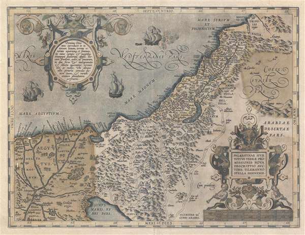
Palestinae Sive Totius Terrae Promissionis Nova Descriptio Auctore Tilemanno Stella Sigenensi.
1603 (undated) 14.5 x 18.5 in (36.83 x 46.99 cm) 1 : 500000
1603 (undated) 14.5 x 18.5 in (36.83 x 46.99 cm) 1 : 500000
Description
This is an old color 1603 Abraham Ortelius map of Palestine or the Holy Land. The map covers from the ancient city of Berytus (Beirut, Lebanon) to the Red Sea and from the Nile River to Damascus (Syria). The map shows the route taken by the wandering Hebrews after the Exodus from Egypt across the Red Sea. The Dead Sea is anomalously depicted in crescent form. A baroque title cartouche sits at the lower-left with a scale underneath. At the upper-right, another decorative cartouche contains a text which describes the area. There are three ships in the Mediterranean, one of which appears to be towing a skiff.
Cartographically, this map is derived from the work of Tileman Stella, an earlier German mapmaker. In contrast to much of Ortelius' other work, which emphasizes the most recent information, his Palestinae Sive Totius is more of a historical map and the geography, spiritual. For Ortelius, who was devout, Old Testament geography was sacred, and no amount of historical or empirical evidence could change what was divine.
This map was printed in 300 copes to accompany the 1603 Latin edition of Ortelius' iconic atlas, the Theatrum Orbis Terrarum.
Cartographer
Abraham Ortelius (April 14, 1527 - June 28, 1598) also known as Ortels, was a cartographer, geographer, and cosmographer of Brabant, active in Antwerp. He was the creator of the first modern atlas, Theatrum Orbis Terrarum and is a seminal figure in the history of cartography. Along with Gerard Mercator and Gemma Frisius, he was a founder of the Netherlandish school of cartography. His connections with Spain - culminating in his 1575 appointment as Royal Cartographer to King Phillip II of Spain - gave him unmatched access to Spanish geographical knowledge during a crucial period of the Age of Discovery. Ortelius was born in 1527 in Antwerp. In 1547 he entered the Antwerp Guild of Saint Luke as an illuminator of maps. He began trading in books, prints, and maps, traveling regularly to the Frankfurt book and print fair, where in 1554 he met Mercator. He accompanied Mercator on journeys throughout France in 1560 and it was at this time, under Mercator's influence, that he appears to have chosen his career as a scientific geographer. His first published geographic work appeared in 1564, an eight-sheet cordiform world map. A handful of other maps preceded the 1570 publication of the first edition of the Theatrum Orbis Terrarum, which would prove to be his life work. Appearing with but 53 maps in its first edition, Ortelius' work expanded with new maps added regularly. By 1592, it had 134 maps. Many of Ortelius' maps remained the standard for nearly a century. He traveled extensively, but his genius was as a compiler, locating the best informed maps on which to base his own. His contacts throughout Europe and extending even (via the Portuguese) to the Far East were formidable. Moreover, many of his maps were based on his own scholarship, particularly his historical works. His theories of geography were particularly ahead of his time with respect to the notion of continental drift, the possibility of which he mused on as early as 1596, and which would be proven correct centuries later.
In a sense his greatest achievement was his successful navigation of the religious and political violence endemic to his city throughout his adult life: The Dutch Revolt, or Eighty Years' War (1568 - 1648), fully embroiled Antwerp. Although outwardly and officially recognized as Catholic (Arias Montanus vouched for Ortelius' Catholic orthodoxy prior to his appointment as Royal Geographer), Ortelius was able to separate himself from the religious furor which characterized the war in the low countries. Ortelius showed a glimpse of himself in a letter to a friend, regarding humanist Justus Lipsius: 'I do not know whether he is an adherent of the Pope or a Calvinist, but if he has ears to hear, he will neither be one nor the other, for sins are committed on both sides'. Ortelius' own explorations of Biblical history in his maps, and the Christogram contained in his own motto, suggest him to be a religious man, but his abjuration of political religious authorities mark him as an individualist. His tombstone at St Michael's Præmonstratensian Abbey in Antwerp bears the inscription, Quietis cultor sine lite, uxore, prole. ('served quietly, without accusation, wife, and offspring.') More by this mapmaker...
Source
Ortelius, A., Theatrum Orbis Terrarum, (Amsterdam) 1603.
Condition
Good. Old color partially oxidized with slight loss. Backed on archival tissue.
References
MacLean, Gerald and Matar, Nabil, Britain and the Islamic World, 1558-1773, (Oxford) 2011, 170-71. OCLC 758543405. Laor, E., Maps of the Holy Land: Cartobibliography of Printed Maps, 1475 - 1900, #538B.