1719 De Fer / Coquart Map of Pamplona, Spain
Pamplona-defer-1719$850.00

Title
Pampelune : Ville Considerable d'Espagne, Capitale de la Haute Navarre.
1719 (dated) 14.25 x 12.5 in (36.195 x 31.75 cm) 1 : 9200
1719 (dated) 14.25 x 12.5 in (36.195 x 31.75 cm) 1 : 9200
Description
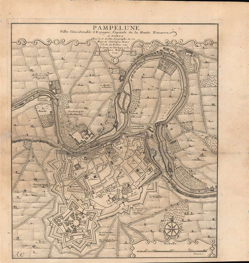
A 1719 Nicholas de Fer city plan or map of Pamplona, Spain, engraved by Antoine Coquart. The primary focus is the fortifications surrounding the city, a reflection of the recent War of the Spanish Succession.
As a result, the emphasis here is on the fortifications surrounding the city, including gates (portes). The castle at bottom, the Ciudadela de Pamplona, is built in the bastion fort or trace italienne style that became dominant in the early modern period. Inside the walled city, important administrative and religious structures are indicated. The Erga River flows on two sides of the city, while features in the surrounding countryside, including farms and more religious sites, are noted.
A Closer Look
Though best known internationally for the 'running of the bulls' today, at the height of the Spanish Empire's power Pamplona was among the most strategically and politically important cities in northern Spain. This map was published in the wake of the War of the Spanish Succession, a long and costly conflict that broke apart the Habsburg realm and, along with the contemporaneous Great Northern War, signaled a shifting balance of power in Europe, with Britain, Russia, and Prussia being major beneficiaries in the long term.As a result, the emphasis here is on the fortifications surrounding the city, including gates (portes). The castle at bottom, the Ciudadela de Pamplona, is built in the bastion fort or trace italienne style that became dominant in the early modern period. Inside the walled city, important administrative and religious structures are indicated. The Erga River flows on two sides of the city, while features in the surrounding countryside, including farms and more religious sites, are noted.
Publication History and Census
This map was engraved by Antoine Coquart and published by Nicolas de Fer in 1719. It is only known to be held by the Bibliothèque nationale de France and the Biblioteca Nacional de España and has no known history on the market. De Fer published several works on fortifications for the French crown in the late 17th and early 18th century, and this map may have been included in one of those works, most likely the extensive Suitte de l'Introduction a la Fortification ou des Forces de l'Europe published in 1736.CartographerS
Nicholas de Fer (1646 - October 25, 1720) was a French cartographer and publisher, the son of cartographer Antoine de Fer. He apprenticed with the Paris engraver Louis Spirinx, producing his first map, of the Canal du Midi, at 23. When his father died in June of 1673 he took over the family engraving business and established himself on Quai de L'Horloge, Paris, as an engraver, cartographer, and map publisher. De Fer was a prolific cartographer with over 600 maps and atlases to his credit. De Fer's work, though replete with geographical errors, earned a large following because of its considerable decorative appeal. In the late 17th century, De Fer's fame culminated in his appointment as Geographe de le Dauphin, a position that offered him unprecedented access to the most up to date cartographic information. This was a partner position to another simultaneously held by the more scientific geographer Guillaume De L'Isle, Premier Geograph de Roi. Despite very different cartographic approaches, De L'Isle and De Fer seem to have stepped carefully around one another and were rarely publicly at odds. Upon his death of old age in 1720, Nicolas was succeeded by two of his sons-in-law, who also happened to be brothers, Guillaume Danet (who had married his daughter Marguerite-Geneviève De Fer), and Jacques-François Bénard (Besnard) Danet (husband of Marie-Anne De Fer), and their heirs, who continued to publish under the De Fer imprint until about 1760. It is of note that part of the De Fer legacy also passed to the engraver Remi Rircher, who married De Fer's third daughter, but Richer had little interest in the business and sold his share to the Danet brothers in 1721. More by this mapmaker...
Antoine Coquart (1703 - 1762) was a French engineer, topographical engraver, and draftsman active in Paris in the first half of the 18th century. Along with Claude Lucas (1685 - 1765), Coquart engraved the great Bretez/Turgot Plan of Paris in 1736 and the subsequent 1748 Jaillot Plan of Paris. He also engraved plates for the 1712 L'Histoire Traite de la Police by Delamare. Learn More...
Condition
Good. Small holes in top margin. Repair in the left-hand margin. Wear along centerfold.
References
OCLC 494598038.