1963 193rd Infantry Brigade Pictorial Map of Panama and the Panama Canal Zone
PanamaCanalZone-193rd-1963$250.00

Title
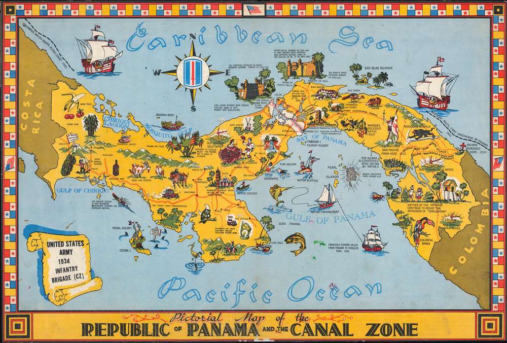
Pictorial Map of the Republic of Panama and the Canal Zone.
1963 (undated) 15.75 x 23.5 in (40.005 x 59.69 cm) 1 : 1250000
1963 (undated) 15.75 x 23.5 in (40.005 x 59.69 cm) 1 : 1250000
Description
This is a c. 1963 193rd Infantry Brigade pictorial map of Panama and the Panama Canal Zone. Pictorial vignettes highlight historical events and sites, along with aspects of Panamanian culture. Natural wonders, including Chorrera Falls and Panama's diverse wildlife. Dotted lines trace Balboa's treks across the isthmus along with the Camino real, the military and treasure road used during the 17th century. The Canal Zone appears as a section of white dividing Panama in two.
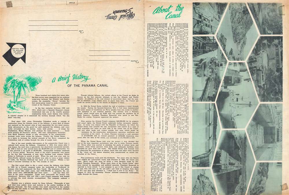
The first proper attempt to build an interoceanic canal was the vision of the French diplomat Ferdinand de Lesseps. Lesseps had been successful in the excavation of the Suez Canal and saw the construction of Panama Canal as a grander, more lucrative, next project. He incorporated the Compagnie Universelle du Canal Interoceanique on March 3, 1881, which purchased a controlling stake in the existing railroad. Unprepared for the jungle climate, all progress was soon mired by disease, poor planning, political posturing, fraud, and bankruptcy. The Compagnie Universelle du Canal Interoceanique was dissolved by a French bankruptcy court on February 4, of 1889, a development that became a major political scandal, in large part because many French legislators had been investors in the company.
Five years later, in 1894, the company's assets were reorganized under new investors as Compagnie Nouvelle du Canal de Panama. This organization immediately began new plans to resume excavations, including producing detailed new maps of the project. Ultimately, the French lost control of the canal project to the United States. In 1903, the Hay-Bunau-Varilla Treaty between Panama and the United States granted the U.S. canal-building rights and the sole right to operate and control the Canal Zone. The Compagnie Nouvelle du Canal de Panama sold its holdings (including the railroad) to the United States in 1904, supplanting an earlier failed American venture to build a canal in Nicaragua, and the Panama Canal officially opened under U.S. Management ten years later in 1914.
Although the canal was an engineering marvel several decades in the making, its opening was marred by the outbreak of the First World War. The high death rate of workers (most of whom were from the Caribbean), especially from yellow fever and malaria, also casts a pall over the success of its construction. Still, the canal drastically cut travel times between the Pacific and Atlantic, was a major asset to the Allies during World War II and has helped Panama to become the wealthiest country in Central America on a per capita basis.
The Canal Zone remained a U.S. territory until the 1977 Torrijos-Carter Treaty began a gradual return of the territory to Panamanian sovereignty and management, a process completed in 2000. After coming under full Panamanian control, a third and wider lane of locks was constructed and opened in 2016, allowing larger 'Panamax' container ships to transit the canal.
Panama Canal
The potential for bridging the narrow isthmus of Panama to link the Pacific and Atlantic Oceans had been conceived long before the completion of the canal, but the hurdles standing in the way of such a connection were formidable, including dense jungle, mountains, and tropical diseases. The first major link across the isthmus was the Panama Railroad, built by a group of American investors in the early 1850s to facilitate the California Gold Rush.The first proper attempt to build an interoceanic canal was the vision of the French diplomat Ferdinand de Lesseps. Lesseps had been successful in the excavation of the Suez Canal and saw the construction of Panama Canal as a grander, more lucrative, next project. He incorporated the Compagnie Universelle du Canal Interoceanique on March 3, 1881, which purchased a controlling stake in the existing railroad. Unprepared for the jungle climate, all progress was soon mired by disease, poor planning, political posturing, fraud, and bankruptcy. The Compagnie Universelle du Canal Interoceanique was dissolved by a French bankruptcy court on February 4, of 1889, a development that became a major political scandal, in large part because many French legislators had been investors in the company.
Five years later, in 1894, the company's assets were reorganized under new investors as Compagnie Nouvelle du Canal de Panama. This organization immediately began new plans to resume excavations, including producing detailed new maps of the project. Ultimately, the French lost control of the canal project to the United States. In 1903, the Hay-Bunau-Varilla Treaty between Panama and the United States granted the U.S. canal-building rights and the sole right to operate and control the Canal Zone. The Compagnie Nouvelle du Canal de Panama sold its holdings (including the railroad) to the United States in 1904, supplanting an earlier failed American venture to build a canal in Nicaragua, and the Panama Canal officially opened under U.S. Management ten years later in 1914.
Although the canal was an engineering marvel several decades in the making, its opening was marred by the outbreak of the First World War. The high death rate of workers (most of whom were from the Caribbean), especially from yellow fever and malaria, also casts a pall over the success of its construction. Still, the canal drastically cut travel times between the Pacific and Atlantic, was a major asset to the Allies during World War II and has helped Panama to become the wealthiest country in Central America on a per capita basis.
The Canal Zone remained a U.S. territory until the 1977 Torrijos-Carter Treaty began a gradual return of the territory to Panamanian sovereignty and management, a process completed in 2000. After coming under full Panamanian control, a third and wider lane of locks was constructed and opened in 2016, allowing larger 'Panamax' container ships to transit the canal.
The 193rd Infantry Brigade and Panama
Following the botched 1961 Bay of Pigs Invasion in Cuba and rumors of Soviet aid to the Cubans, Secretary of Defense Robert McNamara decided to strengthen the U.S. Army presence in the Panama Canal Zone. The 193rd Infantry Brigade, activated August 8, 1962, replaced the battle group in the Canal Zone. The 193rd Infantry Brigade remained in Panama, participated in Operation Just Cause after the abortive 1989 Panamanian elections, and remained in Panama until it was deactivated on October 14, 1994, as part of the Panama Canal Treaty of 1977, mandating the complete withdrawal of U.S. troops by December 1999.Publication History and Census
This map was published by the 193rd Infantry Brigade c. 1963. We note an earlier edition of the present map, which was published c. 1950 by the Engineer Reproduction Plant of the U.S. Army Caribbean and was drawn by B. J. Carter. We have not found a digitized example of the original Carter edition, so we have been unable to verify a date. Due to variations in catalog entries involving maps bearing this title, we also have not been able to determine a solid census for the present map.Condition
Average. Closed tear extending two-and-one-quarter (2.25) inches through printed area in word 'Caribbean' professionally repaired on verso. Old tape residue on verso. Text and printed images on verso.