Digital Image: 1950 Sheets Pictorial Map of Northern California
PanoramaTodayNorCal-sheets-1950_d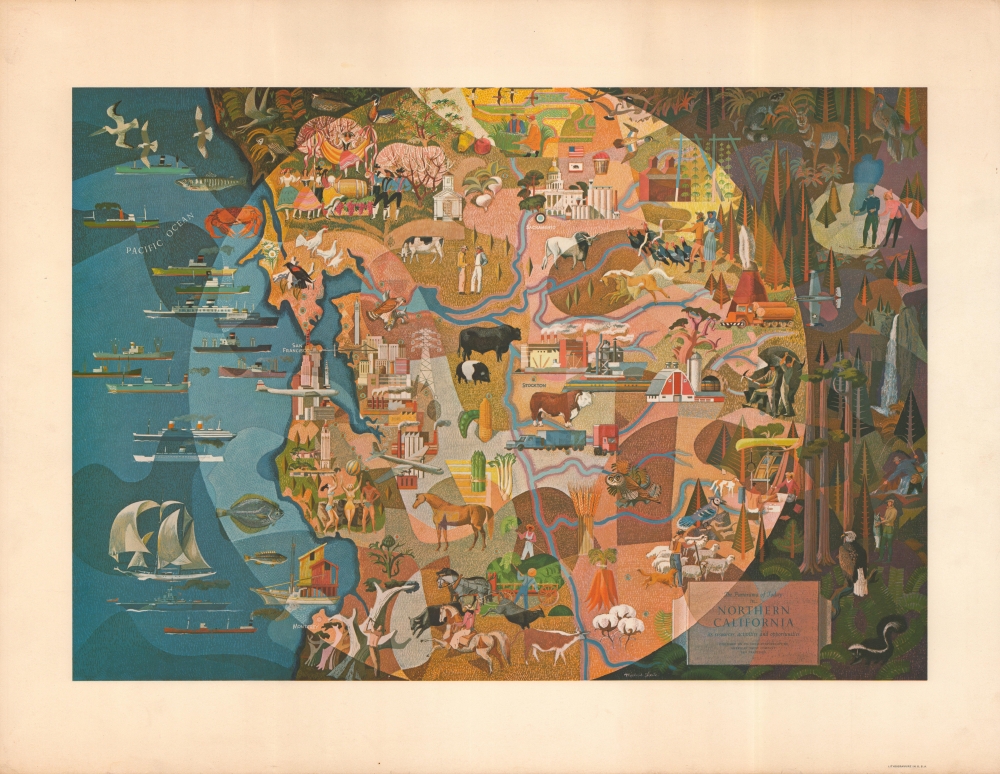

Title
The Panorama Today in Northern California its resources activities and opportunities.
1950 (undated) 15 x 21.5 in (38.1 x 54.61 cm) 1 : 725000
1950 (undated) 15 x 21.5 in (38.1 x 54.61 cm) 1 : 725000
Description
FOR THE ORIGINAL ANTIQUE MAP, WITH HISTORICAL ANALYSIS, CLICK HERE.
Digital Map Information
Geographicus maintains an archive of high-resolution rare map scans. We scan our maps at 300 DPI or higher, with newer images being 600 DPI, (either TIFF or JPEG, depending on when the scan was done) which is most cases in suitable for enlargement and printing.
Delivery
Once you purchase our digital scan service, you will receive a download link via email - usually within seconds. Digital orders are delivered as ZIP files, an industry standard file compression protocol that any computer should be able to unpack. Some of our files are very large, and can take some time to download. Most files are saved into your computer's 'Downloads' folder. All delivery is electronic. No physical product is shipped.
Credit and Scope of Use
You can use your digial image any way you want! Our digital images are unrestricted by copyright and can be used, modified, and published freely. The textual description that accompanies the original antique map is not included in the sale of digital images and remains protected by copyright. That said, we put significant care and effort into scanning and editing these maps, and we’d appreciate a credit when possible. Should you wish to credit us, please use the following credit line:
Courtesy of Geographicus Rare Antique Maps (https://www.geographicus.com).
How Large Can I Print?
In general, at 300 DPI, you should at least be able to double the size of the actual image, more so with our 600 DPI images. So, if the original was 10 x 12 inches, you can print at 20 x 24 inches, without quality loss. If your display requirements can accommodate some loss in image quality, you can make it even larger. That being said, no quality of scan will allow you to blow up at 10 x 12 inch map to wall size without significant quality loss. For more information, it is best consult a printer or reprographics specialist.
Refunds
If the high resolution image you ordered is unavailable, we will fully refund your purchase. Otherwise, digital images scans are a service, not a tangible product, and cannot be returned or refunded once the download link is used.
Cartographer
Millard Owen Sheets (June 24, 1907 - March 31, 1989) was an American artist and designer best known for his watercolors and murals. Born in Southern California, he attended the Chouinard Art Institute and was a student of Frank Tolles Chamberlin and Clarence Hinkle. Even before graduating, he was highly regarded for his watercolors and his work was soon displayed all over the country. During the Great Depression, he was a leading figure in the Public Works of Art Project, and during the Second World War, he spent time in South Asia as an artist-correspondent. During the 1930s-1940s, he increasingly took up large-scale mural projects, including mosaic murals. He also worked in bronze sculpture and stained glass, and also produced architectural designs. His works are strongly influenced by Realism, taking working and oppressed peoples as their subject, and bear some resemblance to other celebrated artists of the era, such as Diego Rivera. Sheets is considered one of the founders of California Scene Painting. More by this mapmaker...
References
Rumsey 8080.000. OCLC 83749561, 953572733.