Digital Image: 1797 Jean Map of Paris and the Faubourgs, France
Paris-jean-1797_d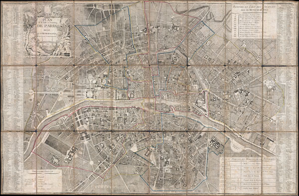

Title
Plan de la Ville et Faubourg de Paris Divise en 12 Municipalites.
1797 (dated) 26 x 39 in (66.04 x 99.06 cm)
1797 (dated) 26 x 39 in (66.04 x 99.06 cm)
Description
FOR THE ORIGINAL ANTIQUE MAP, WITH HISTORICAL ANALYSIS, CLICK HERE.
Digital Map Information
Geographicus maintains an archive of high-resolution rare map scans. We scan our maps at 300 DPI or higher, with newer images being 600 DPI, (either TIFF or JPEG, depending on when the scan was done) which is most cases in suitable for enlargement and printing.
Delivery
Once you purchase our digital scan service, you will receive a download link via email - usually within seconds. Digital orders are delivered as ZIP files, an industry standard file compression protocol that any computer should be able to unpack. Some of our files are very large, and can take some time to download. Most files are saved into your computer's 'Downloads' folder. All delivery is electronic. No physical product is shipped.
Credit and Scope of Use
You can use your digial image any way you want! Our digital images are unrestricted by copyright and can be used, modified, and published freely. The textual description that accompanies the original antique map is not included in the sale of digital images and remains protected by copyright. That said, we put significant care and effort into scanning and editing these maps, and we’d appreciate a credit when possible. Should you wish to credit us, please use the following credit line:
Courtesy of Geographicus Rare Antique Maps (https://www.geographicus.com).
How Large Can I Print?
In general, at 300 DPI, you should at least be able to double the size of the actual image, more so with our 600 DPI images. So, if the original was 10 x 12 inches, you can print at 20 x 24 inches, without quality loss. If your display requirements can accommodate some loss in image quality, you can make it even larger. That being said, no quality of scan will allow you to blow up at 10 x 12 inch map to wall size without significant quality loss. For more information, it is best consult a printer or reprographics specialist.
Refunds
If the high resolution image you ordered is unavailable, we will fully refund your purchase. Otherwise, digital images scans are a service, not a tangible product, and cannot be returned or refunded once the download link is used.
Cartographer
Pierre Jean (1754 - 1829) was a French engraver, publisher, print seller, and map maker active in Paris in the late 18th and early 19th centuries. Jean entered the engraving and printing business on June 7 of 1784 when he married the daughter of Louis-Joseph Mondhare, a prominent French engraver, print seller and map publisher. Mondhare changed the name of his firm to Mondhare & Jean. Under Mondhare, for about 12 years, Jean mastered the in-and-outs of the engraving and map publishing business. Mondhare retired in 1796, leaving Jean his business and printing plates. Jean subsequently continued to publish on his own account, as Chez Jean, from the old Mondhare & Jean offices at 32 Rue Saint-Jean de Beauvais. More by this mapmaker...